

Latest Weather Blog
Monday evening video forecast
Related Story
The chances of beneficial rain will quickly decline for the remainder of the week. As a result, high temperatures will find levels well above average in the upper 90s.
Tonight & Tomorrow: Lingering showers and thunderstorms will wrap up shortly after sunset. The overnight hours will stay muggy with low temperatures in mid 70s. Tuesday will be warm and humid. The afternoon hours will warm into the mid 90s beneath partly sunny skies. There may be a stray shower or thunderstorm, but most will stay dry.
Up Next: Wednesday through Friday will be rather hot. It is not out of the question that one or two spots scares up 100 degrees. All will make it into the upper 90s. Overnight low temperatures will be in the mid to upper 70s. As far as rain chances go, they are low but not zero. Especially late in the afternoon, some activity could push in from the northwest providing a stray shower. A weak front will dive south into the area on Saturday. This front is expected to stir up a few showers and thunderstorms. Changes on the other side will be minimal, but there could be a little lower humidity for the second half of the weekend. Looking at those first tailgates in Baton Rouge on Saturday, be prepared for a passing shower or thunderstorm, but there are no indications of a washout. Otherwise, it will be very warm and humid.
Get the latest 7-day forecast and real time weather updates HERE.
Watch live news HERE.
The Tropics: Tropical Storm Gert has been absorbed by the remnants of Idalia and has dissipated over the north Atlantic Ocean. The area of disturbed weather is still producing 50mph winds. Tropical Storm Katia is expected to become a remnant low overnight in the far eastern Atlantic Ocean. The system will make a clockwise loop while diminishing.
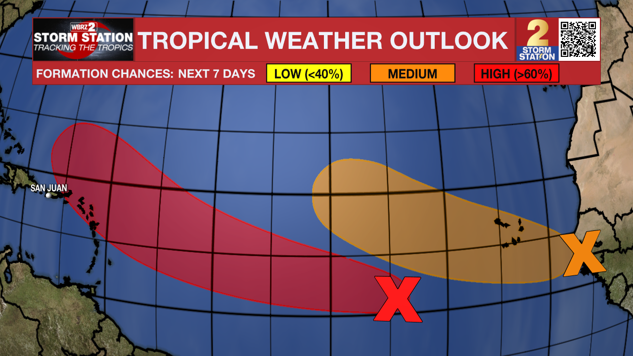
Satellite imagery indicates that an area of low pressure has formed from the tropical wave centered about 700 miles west-southwest of the Cabo Verde Islands. The low-level circulation has become better defined since yesterday, with increasing organization in the shower and thunderstorm activity. Environmental conditions are forecast to be conducive for further development, and this system will become a tropical depression or a tropical storm in a day or two. Additional strengthening is likely late this week while the system moves westward to west-northwestward at 15 to 20 mph over the central and western portions of the tropical Atlantic.
A strong tropical wave over western Africa is forecast to move off the African coast in a couple of days. Environmental conditions should support some slow development, and there is a fifty percent chance that a tropical depression could form over the far eastern tropical Atlantic around the latter part of the week or the weekend while the wave moves to the west-northwest at about 15 mph.
Post-Tropical Cyclone Franklin is located several hundred miles north of the Azores and is forecast to move quickly southeastward towards warmer waters east of Azores. This system could acquire some subtropical or tropical characteristics late this week or this weekend while it moves erratically between the Azores and Portugal.
--Josh
The Storm Station is here for you, on every platform. Your weather updates can be found on News 2, wbrz.com, and the WBRZ WX App on your Apple or Android device. Follow WBRZ Weather on Facebook and Twitter for even more weather updates while you are on the go.
News
