

Latest Weather Blog
Monday evening video forecast
Related Story
No shocker here… the high heat will continue all week long. Any showers and thunderstorms will be unlikely.
A *HEAT ADVISORY* will be in effect on Tuesday from 12pm - 7pm for all of southeast Louisiana and southwest Mississippi. Heat index values up to 112 may cause heat illnesses to occur.
Drink plenty of fluids, stay in an air-conditioned room, stay out of the sun, and check up on relatives and neighbors. Young children and pets should never be left unattended in vehicles under any circumstances. Take extra precautions if you work or spend time outside. When possible reschedule strenuous activities to early morning or evening. Know the signs and symptoms of heat exhaustion and heat stroke. Wear lightweight and loose fitting clothing when possible. To reduce risk during outdoor work, the Occupational Safety and Health Administration recommends scheduling frequent rest breaks in shaded or air conditioned environments. Anyone overcome by heat should be moved to a cool and shaded location. Heat stroke is an emergency!
Tonight & Tomorrow: Any pop up showers will decay after sunset. With skies turning mostly clear, low temperatures will slide into the upper 70s. On Tuesday, plenty of early sunshine will force high temperatures to soar back into the upper 90s. Humidity will push feels-like temperatures into the 107-112 range. A stray shower is unlikely, but not impossible.
Up Next: Through the workweek, highs will be in the upper 90s, with one or two spots possibly reaching the century mark, and lows will struggle to leave the 80s. Plenty of humidity will stick around and afternoon feels-like temperatures over 107 degrees will likely warrant continuous heat alerts from the National Weather Service. Chances for rain will be near zero through Friday. Over the weekend, the dominant ridge of high pressure causing the ongoing heat and dry conditions will weaken and move a little west of the area. Temperatures will retreat a few degrees closer to average, especially as afternoon showers and thunderstorms become possible once again.
Get the latest 7-day forecast and real time weather updates HERE.
Watch live news HERE.
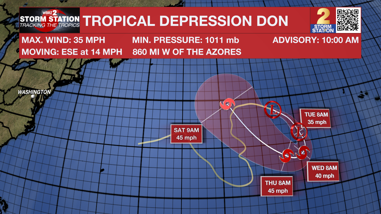
The Tropics: Tropical Depression Don continues to loop around in the central Atlantic Ocean. Don was producing maximum sustained winds of 35mph and moving southeast at 14mph. The storm is expected to turn south on Tuesday and then west and back to the northwest by Thursday. It could even become a tropical storm again later this week.
--Josh
The Storm Station is here for you, on every platform. Your weather updates can be found on News 2, wbrz.com, and the WBRZ WX App on your Apple or Android device. Follow WBRZ Weather on Facebook and Twitter for even more weather updates while you are on the go.
News
