67°
Baton Rouge, Louisiana
7 Day Forecast


Latest Weather Blog
Main Weather Tune In 6a 1-1-20
Related Story
New Year's Day starts off fair while clouds steadily increasing throughout the day as rainfall begins Wednesday evening. Models have come in better agreement slowing the system down suggesting isolated storms with a heavier rain event farther north and west.
THE FORECAST:
Today and Tonight: Clouds quickly increase as the high will reach near 60 degrees on Wednesday. New Year’s Day rain chances remain as the next system from the west approaches. Expect conditions to diminish through the evening into Thursday as rain and storms build over the region. High near 60, lows in the low 50s.
Up Next: By Thursday a possible risk of isolated storms. The National Weather Service has placed a slight risk of excessive rain for SW & central Louisiana including southwest Mississippi. 2-4 inches of rain from the Atchafalaya Basin to southwest Mississippi during the next 24-36 hours. This rain/storm event is associated with a low pressure system over northern Mexico tracking toward the northern & central gulf teaming up with a cold front exiting the Rockies.
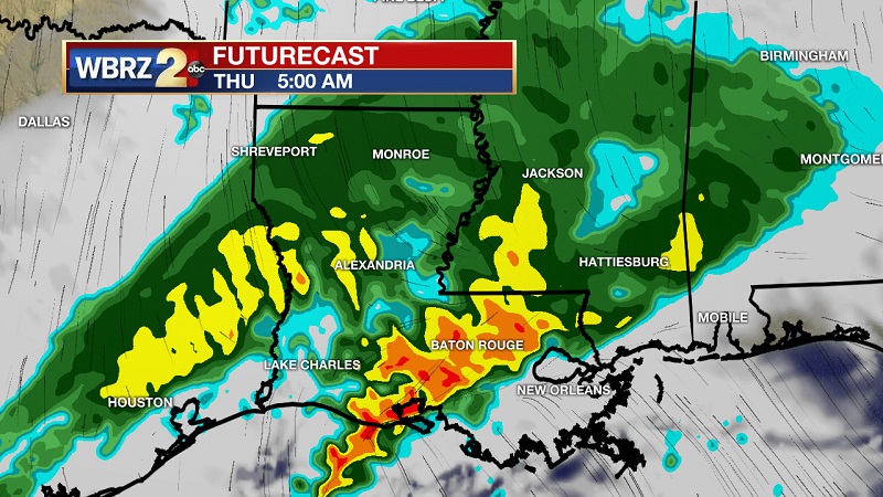
The exact track of the surface low will play the main role on the weather scenario in southeast Louisiana and southwest Mississippi. Keeping a watch on trends as they continue to compare as we move forward in time. Both scenarios will allow rain and isolated storms during the forecast period starting tonight through midday Friday. By Friday afternoon, cool and quiet weather returns for the first weekend of 2020.
News
Radar
7 Days
