

Latest Weather Blog
Friday Evening Video Forecast
Related Story
We aren’t necessarily done with the 90s just yet. Highs may hit the 90° mark on Saturday, which is within reach of the record. These above-average temperatures stick around into next week, along with limited rain chances. Expect little to no drought relief for the last full week of October.
Tonight & Tomorrow: Temperatures will cool off nicely on Friday night after a very warm afternoon. We’ll keep clear skies for most of the overnight hours. We expect morning lows on Saturday in the upper-50s. By sunrise, we’ll be watching some high clouds moving in from the west. This veil of high clouds will give the sky more of a filtered sunshine appearance through the rest of the day. Despite the clouds, it will be very warm for all tailgaters prior to the LSU homecoming game. Temperatures will be near 90° by peak heating. This is flirting with the record high on Saturday in Baton Rouge, which is currently 91° (1919). Temperatures cool to the lower-80s around kickoff with falling temperatures during the game.

Up Next: High clouds thicken overnight Saturday and into Sunday. We’ll be mostly cloudy for the second half of the weekend. This should result in slightly cooler temperatures on Sunday. That said, highs still range anywhere from 5-10° above average on Sunday and through next week.
Rain chances are limited also. That could change late next week, but we’re still not convinced that a lot of rain arrives by Thursday and Friday. For now, we’re going with a 10% rain coverage to cap off the workweek. While the forecast is still subject to change, we're very confident that the capital area stays bone dry through Wednesday.
Get the latest 7-day forecast and real time weather updates HERE.
Watch live news HERE.
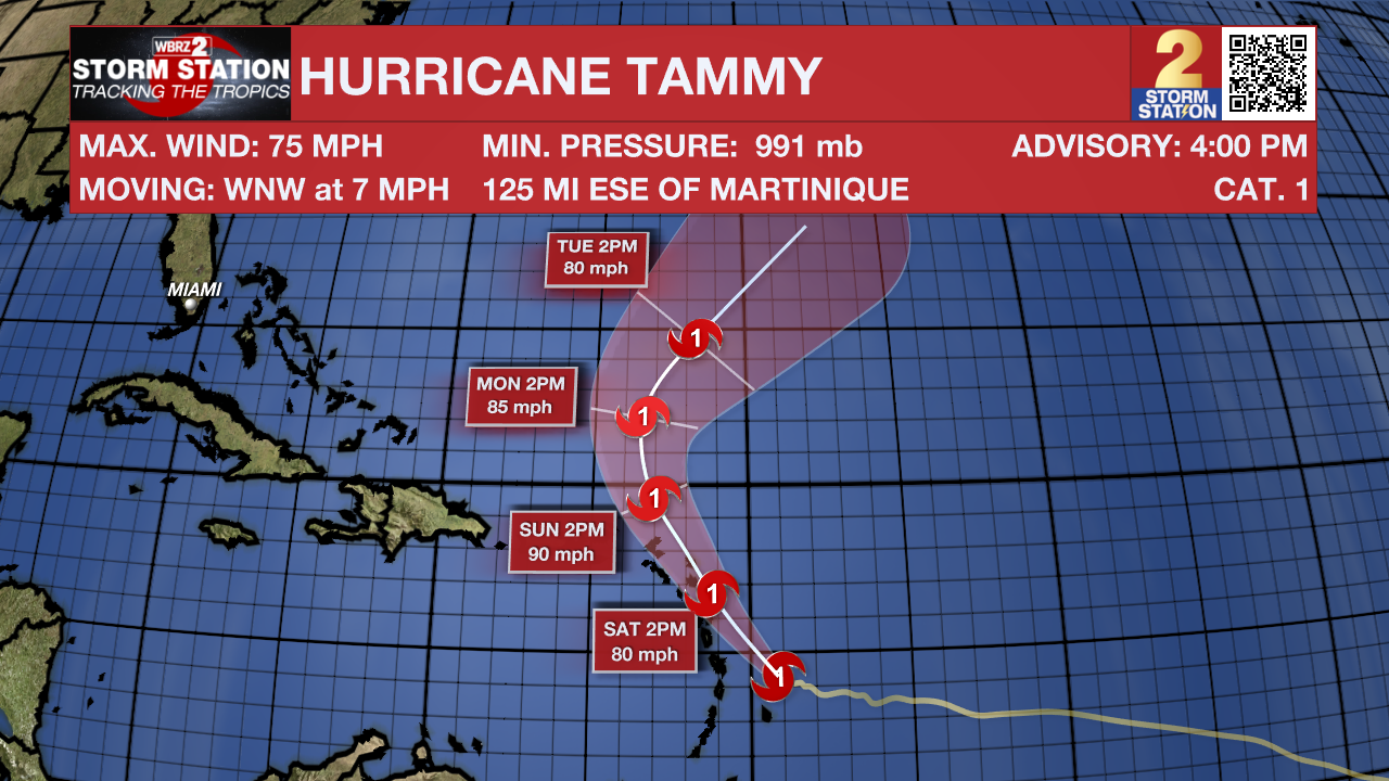
The Tropics: Tammy strengthened into a Category 1 hurricane on Friday as the storm continued to approach the Lesser Antilles. Various tropical alerts, including Hurricane Warnings, are in effect for the islands that make up the Lesser Antilles. Several inches of rain, a few feet of storm surge, and at least tropical storm force winds are possible in the region.
Tammy is moving northwest, almost paralleling the Lesser Antilles. The system will gradually strengthen through the weekend before curving out to sea next week.
The National Hurricane Center is also watching an area of showers and storms over the far southwest Caribbean. Slow development of this system is possible through the weekend before moving inland over Central America early next week. This tropical wave has a very low chance of organization into a tropical depression and will not affect the United States.
-- Meteorologist Malcolm Byron
The Storm Station is here for you, on every platform. Your weather updates can be found on News 2, wbrz.com, and the WBRZ WX App on your Apple or Android device. Follow WBRZ Weather on Facebook and Twitter for even more weather updates while you are on the go.
News
