

Latest Weather Blog
Friday evening video forecast
Related Story
The so-called heat dome will stay out west a few days longer keeping the door open for a more typical pattern of scattered showers and thunderstorms. They affected a little less of the area than expected toward the end of the week. With little change to the pattern heading into the weekend, the forecast is status quo.
Tonight & Tomorrow: Lingering showers and thunderstorms will taper into the evening hours. With partly cloudy skies, low temperatures will dip into the mid 70s. Saturday will begin with partly sunny skies and high temperatures will surge into the mid 90s. By afternoon, isolated showers and thunderstorms will flare up, bringing rain to about forty percent of the forecast area. Outdoor plans are not in danger of being washed out.
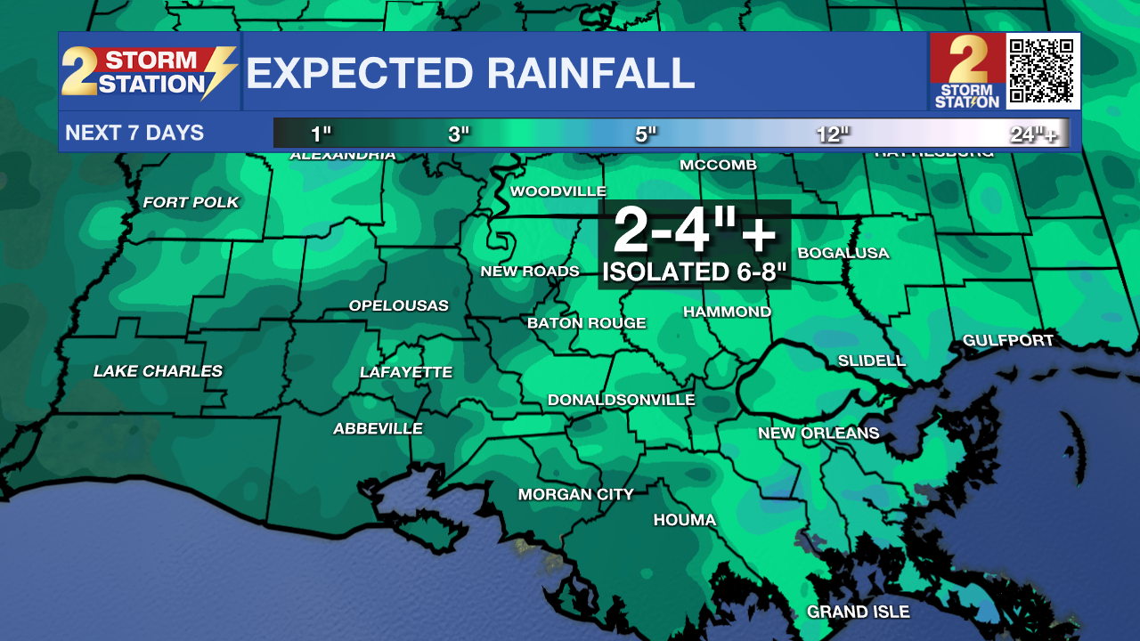
Up Next: Of the two weekend days, Sunday looks more active than Saturday, but still not a washout. For temperatures, highs will be in the mid 90s and lows will be in the mid 70s. There will be a risk of some heavy rain on Monday which is shaping up to be the busiest of the Storm Station 7-Day Forecast. Scattered showers and thunderstorms will stay in the forecast on Tuesday. Through that stretch, most areas will collect a few inches of rain, though some isolated pockets could receive 6-8 inches. If those amounts come in a short time, some nuisance, street and poor drainage flooding could occur.
For the second half of next week, that ridge of high pressure and warmer temperatures will start to expand east and over the Gulf Coast leading to higher temperatures and fewer showers and thunderstorms. However, at this time, it does not look like they will shut down entirely.
Get the latest 7-day forecast and real time weather updates HERE.
Watch live news HERE.
The Tropics: For the North Atlantic, Caribbean Sea and Gulf of Mexico, all is quiet. No tropical development is expected over the next seven days.
On Thursday, the major research outfit at Colorado State University updated their hurricane season outlook. All the numbers have been given a bump up, even including the three systems that have formed so far. The experts attribute the above average outlook to extremely warm water temperatures overcoming the strengthening El Niño, which typically curtails the number of storms that form.
--Josh
The Storm Station is here for you, on every platform. Your weather updates can be found on News 2, wbrz.com, and the WBRZ WX App on your Apple or Android device. Follow WBRZ Weather on Facebook and Twitter for even more weather updates while you are on the go.
News
