

Latest Weather Blog
Friday evening video forecast
Related Story
The threat for flooding will go lower and lower each day. However, showers and thunderstorms will stay in the forecast.
Next 24 Hours: Tonight, the last of the showers will diminish by midnight. Skies will be mostly cloudy with low temperatures dipping into the mid 70s. Tomorrow, some more sunshine will be available to bump high temperatures into the upper 80s and perhaps low 90s. In response to the warming, a healthy scattering of showers and thunderstorms will then develop. Don’t expect a washout, but be prepared to take any outdoor activities inside briefly.
Up Next: Sunday will possibly have the fewest showers and thunderstorms in the area for the whole 7-Day Forecast—but that is not to say zero showers and thunderstorms. Thermometers should pop into the 90s in most neighborhoods as a result. Monday through much of next week, very humid conditions will help scattered showers and thunderstorms develop each day from late morning through late afternoon. High temperatures will be in the upper 80s. Nights will feature quieter conditions. Low temperatures will be in the mid 70s. CLICK HERE for your detailed 7-Day Forecast.
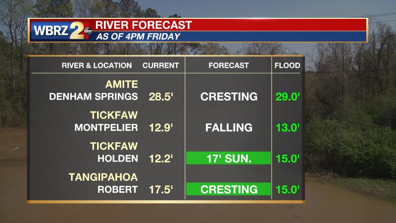
Area rivers have been on the rise due to the recent rainfall. Other than the Tangipahoa at Robert, none are expected to crest above flood stage.
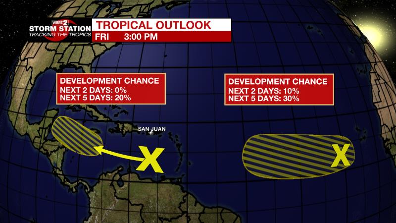
The Tropics: A broad and complex area of low pressure over the eastern tropical Atlantic Ocean is producing disorganized showers and thunderstorms. The interaction of this feature with an approaching tropical wave offers a thirty percent chance of some gradual development of the system during the early and middle parts of next week while it moves slowly westward to west-northwestward across the eastern and central tropical Atlantic.
A trough of low pressure located over the eastern Caribbean Sea is producing limited shower and thunderstorm activity. Environmental conditions could become more conducive and there is a twenty percent chance for slow development of this system during the early or middle part of next week while it moves generally westward at 10 to 15 mph across the central and northwestern Caribbean Sea.
The Explanation: Over the weekend, the stubborn surface boundary and upper level trough that has been anchored over the region will weaken while moisture in the atmosphere decreases ever so slightly. Still, plenty of instability will remain while moisture keeps above average. The net result will be fewer showers and thunderstorms and a lower threat for heavy remain, but by no means will we be displaying a dry forecast. Moisture will surge higher once again on Monday and remain well above average through much of next week. Since there will be no major upper level ridges or trough, daytime warming should efficiently pop showers and thunderstorms every day. Isolated instances of heavy rain or gusty wind will be possible. High temperatures will generally stick a few degrees below average with convection initiating by midday.
--Josh
The Storm Station is here for you, on every platform. Your weather updates can be found on News 2, wbrz.com, and the WBRZ WX App on your Apple or Android device. Follow WBRZ Weather on Facebook and Twitter for even more weather updates while you are on the go.
News
