

Latest Weather Blog
FRIDAY AM FORECAST 8/25
Related Story
High temperatures in excess of 100 degrees will be possible all the way through the weekend. A weak cold front will approach the area on Monday and Tuesday. This will knock down the temperatures a bit and potentially provide some much needed rain.
A ***RED FLAG WARNING*** is in effect until 8pm tomorrow. Any fires that develop will likely spread rapidly. A Burn Ban is already in place for all areas.
A ***HEAT ADVISORY*** is in effect until 8pm tomorrow for the entire WBRZ Viewing Area. Dangerously hot conditions with heat index values up to 111 expected. Extreme heat and humidity will significantly increase the potential for heat related illnesses, particularly for those working or participating in outdoor activities. Drink plenty of fluids, stay in an air-conditioned room, stay out of the sun, and check up on relatives and neighbors.
Today & Tonight: Friday looks to be another record-breaking day in terms of the heat. Highs will top out near 104 degrees under mostly sunny skies. Feels like temperatures because of high humidity, could reach near 111 degrees. Again, there may be a stray shower or thunderstorm late in the day.The nighttime hours will be quiet and muggy with lows right around 79 degrees.
Up Next: The weekend is going to stay hot but rain coverage will be on the rise starting on Saturday. Spotty showers and thunderstorms will be possible on Saturday, and to a lesser extent Sunday, but the best chance of rain we have seen in a while will come Monday and Tuesday. A weak cold front looks to slide into the area and this will potentially break the string of 100 degree highs we have been seeing. The front will serve as a trigger for precipitation. There is even a chance it will move through and lower temperatures and humidity a little for the middle of next week.
Get the latest 7-day forecast and real time weather updates HERE.
Watch live news HERE.
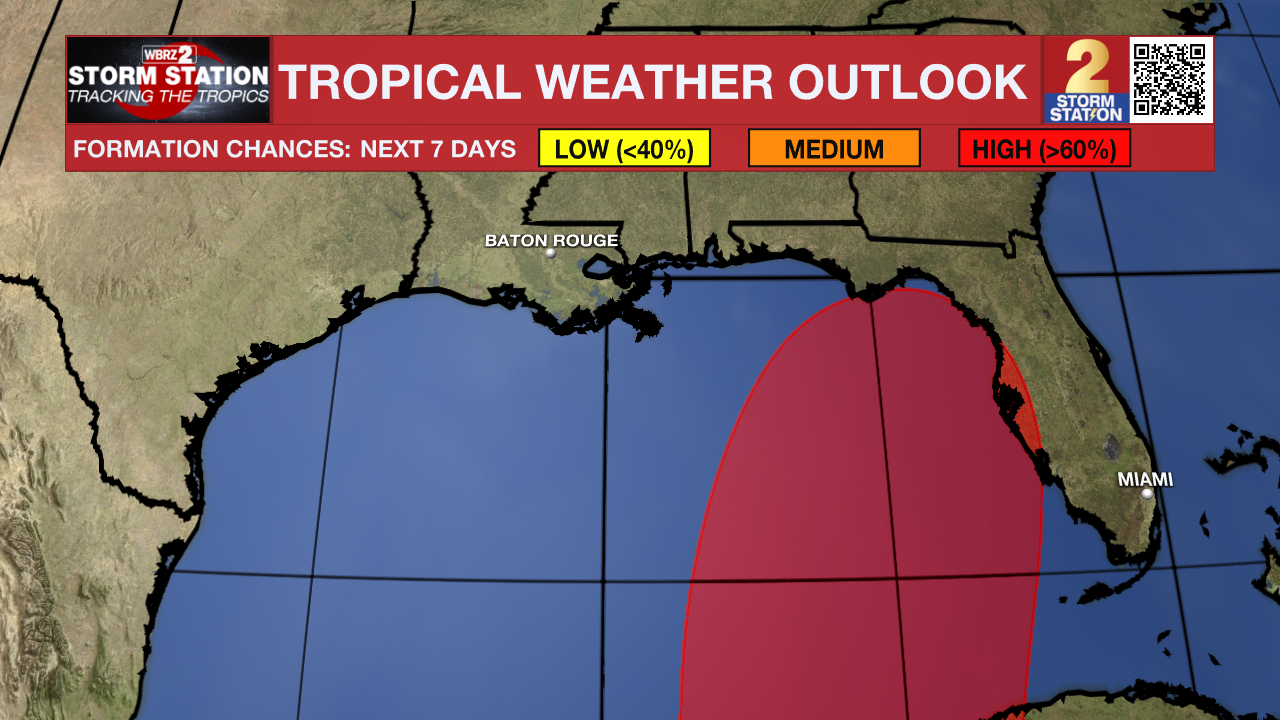
The Tropics: A broad area of low pressure centered over Central America is forecast to move into the northwestern Caribbean Sea by this weekend. Some gradual development of this system is possible thereafter into early next week, and a tropical depression could form while it moves slowly northward, entering the eastern Gulf of Mexico.
Franklin has moved into the southwest Atlantic and is going to strengthen into the season's second hurricane. It is no threat to the Gulf of Mexico.
There are two tropical waves located on the central Atlantic, and they have medium chances of becoming tropical depressions. These are no threat to the United States.
--Keller
The Storm Station is here for you, on every platform. Your weather updates can be found on News 2, wbrz.com, and the WBRZ WX App on your Apple or Android device. Follow WBRZ Weather on Facebook and Twitter for even more weather updates while you are on the go.
News
