

Latest Weather Blog
Wednesday PM Forecast: slow transition from standard to steamy
A weak front will meander around the area through the end of the workweek. This will serve as a trigger for afternoon showers and thunderstorms. Higher heat comes back later in the Storm Station 7-Day Forecast.
Tonight & Tomorrow: Expect a partly cloudy and quiet night. Any spotty showers will diminish shortly after nightfall and temperatures will ease back into the low 70s, which is average for the time of year. Thursday will be partly sunny and seasonably warm with high temperatures chugging into the low 90s. A very weak surface boundary, or front, will spark isolated showers and thunderstorms during the afternoon and evening hours. While not as severe as earlier in the week, any of these storms could produce gusty wind, hail and downpours.
Up Next: For Friday, it will be a rinse and repeat forecast. Saturday will be the transitional day as far as weather is concerned. Temperatures will start to turn a little hotter as that weak front drifts farther north of the area. Isolated showers and thunderstorms will remain a possibility. By Sunday, and then well into next week, an upper level ridge of high pressure will build over the Gulf Coast. This common feature tends to bounce back and forth across the southern United States during the summer. When overhead, we get stretches of very hot temperatures and minimal rain coverage. Next week, look for a return to highs in the upper 90s and lows in the upper 70s. Once again, we may need advisories or warnings for the heat.
Get the latest 7-day forecast and real time weather updates HERE.
Watch live news HERE.
Trending News
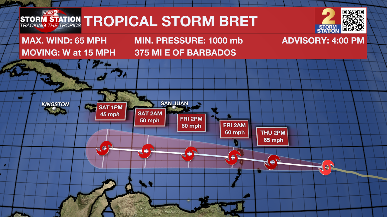
The Tropics: Tropical Storm Bret continues to gradually strengthen about 500 miles east of Barbados. The storm is moving west at 15mph with maximum sustained winds of 65mph. Bret should remain steady in intensity and speed as it brushes over the Lesser Antilles on Thursday followed by weakening and eventual dissipation over the Caribbean Sea this weekend in the face of harsh wind shear.
In the eastern Atlantic, recent satellite data indicate the area of low pressure located about midway between the west coast of Africa and the Lesser Antilles has an elongated surface circulation with maximum sustained winds of about 30 mph. However, showers and thunderstorms continue to show signs of organization. There is an eighty percent chance that a tropical depression will form during the next day or so while the system moves westward to west-northwestward at 10 to 15 mph across the central tropical Atlantic through the early part of the weekend.
--Josh
The Storm Station is here for you, on every platform. Your weather updates can be found on News 2, wbrz.com, and the WBRZ WX App on your Apple or Android device. Follow WBRZ Weather on Facebook and Twitter for even more weather updates while you are on the go.
More News
