

Latest Weather Blog
Wednesday PM Forecast: heat unrelenting into the weekend
The heat will be unrelenting through the weekend. Pop up showers are unlikely, but not impossible. A better chance for some rain may develop next week.
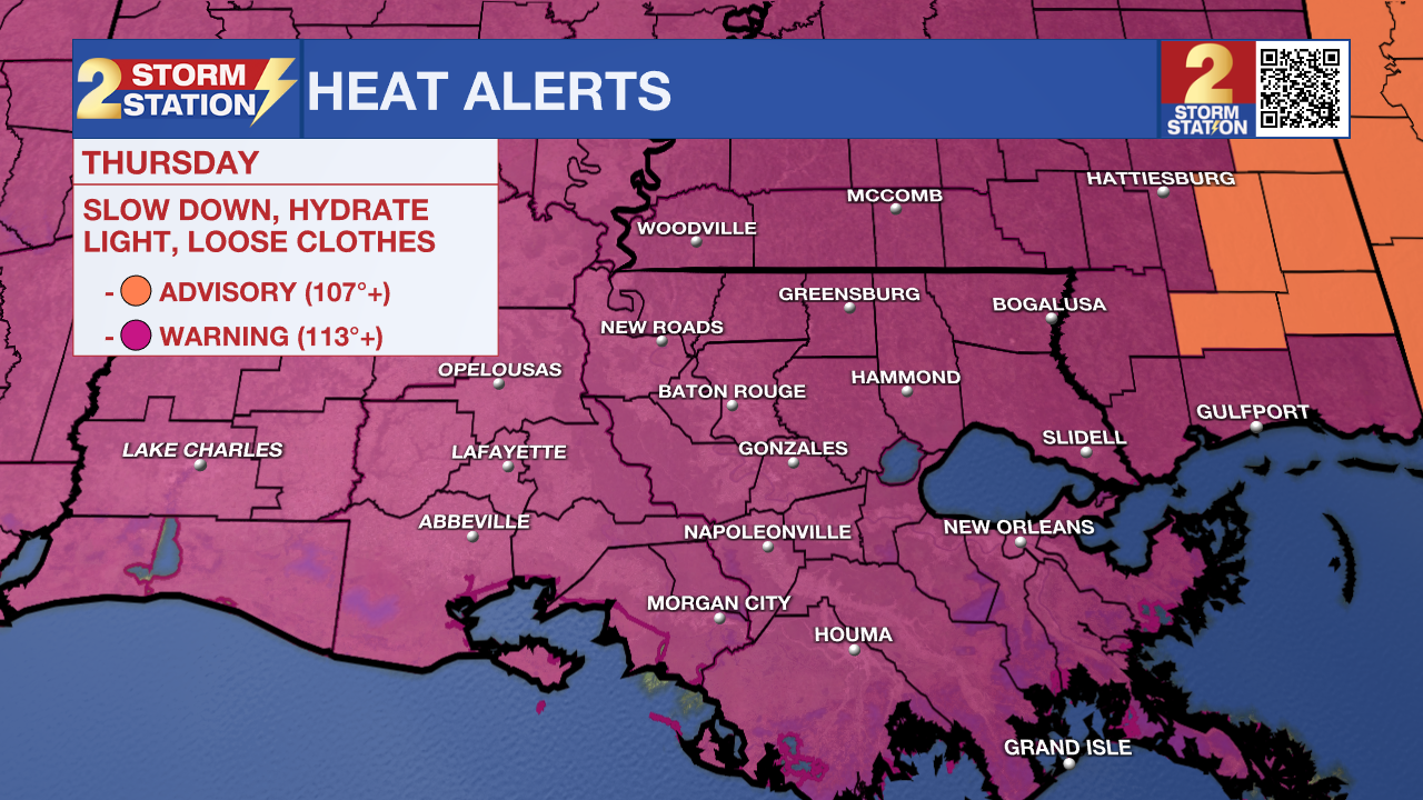
An EXCESSIVE HEAT WARNING will be in effect Thursday from 11am to 7pm for the entire Storm Station Forecast Area. Dangerously hot conditions with heat index values up to 115 degrees are expected. Extreme heat and humidity will significantly increase the potential for heat related illnesses, particularly for those working or participating in outdoor activities.
Drink plenty of fluids, stay in an air-conditioned room, stay out of the sun, and check up on relatives and neighbors. Young children and pets should never be left unattended in vehicles under any circumstances. Take extra precautions if you work or spend time outside. When possible reschedule strenuous activities to early morning or evening. Know the signs and symptoms of heat exhaustion and heat stroke. Wear lightweight and loose fitting clothing when possible. To reduce risk during outdoor work, the Occupational Safety and Health Administration recommends scheduling frequent rest breaks in shaded or air conditioned environments. Anyone overcome by heat should be moved to a cool and shaded location.
Tonight & Tomorrow: Beneath mostly clear skies, low temperatures will keep to the low 80s for the 19th time this year. Winds will be light and out of the southwest. Plenty of early sunshine will drive temperatures into the upper 90s by lunchtime on Thursday with most maximizing around 100 degrees during the afternoon. Adding in seasonably high humidity will result in feels-like temperatures over 113 degrees at times between late morning and late afternoon. Most locations will stay dry.
Trending News
Up Next: Friday will be mainly dry and hot with temperatures reaching the century mark again. Over the weekend, thermometers will race through the 80s and into the 90s during the morning hours and ultimately top out near 100 degrees each afternoon. The heat index will continue to reach alert criteria, making it to at least 107 degrees each day and possibly as high at 118 degrees at times. Daily rain coverage looks to stay at 20 percent or less. By the end of the weekend, the stubborn heat dome my show just enough weakness to introduce some pop-up afternoon showers and thunderstorms but with the persistence of this pattern for more than a month, it is too early to call for an end.
Get the latest 7-day forecast and real time weather updates HERE.
Watch live news HERE.
The Tropics: For the Gulf of Mexico, Caribbean Sea and Atlantic Ocean, there are no active storms. Tropical development is not expected over the next seven days.
--Josh
The Storm Station is here for you, on every platform. Your weather updates can be found on News 2, wbrz.com, and the WBRZ WX App on your Apple or Android device. Follow WBRZ Weather on Facebook and Twitter for even more weather updates while you are on the go.
More News
