

Latest Weather Blog
Wednesday PM Forecast: clouds remain stubborn until next cold front
Many locations have received between one and two inches of rain since Monday. Any lingering mist or drizzle will not measure up to much but clouds will be stubborn until the next front arrives.
Tonight & Tomorrow: Light mist and drizzle could carry well into the evening hours. Clouds will be stubborn overnight. Northeast winds of 10-15mph will keep a raw feel to the otherwise damp air with low temperatures pegged for the upper 50s. Thursday will be another day filled with clouds. There is some optimism for a few breaks of sun during the afternoon hours and high temperatures attempt to reach the upper 60s and low 70s.
Up Next: The workweek will end with mostly cloudy skies and high temperatures in the 70s. A fast moving cold front will swoop through the region late Friday and into Saturday. This feature is likely to pass by dry and with plenty of dry air trailing the system, clouds will finally be flushed from skies for a little while this weekend. Saturday will begin with some lingering clouds and temperatures in the upper 50s but returning sunshine will help to bump readings back into the mid 70s. A jacket kind of start is expected on Sunday with lows in the mid 40s. Early sun will help highs into the low 70s before clouds increase ahead of active weather coming in on Monday.
A frontal system will bring scattered showers and thunderstorms to the area as the new week begins. Details on how much rain, and even the possibility of stronger thunderstorms will come into focus toward the weekend. Either way, be aware that this system could impact one or both commutes on Monday. Much cooler temperatures will push in behind this feature to leave us with below average temperatures for Thanksgiving.
Get the latest 7-day forecast and real time weather updates HERE.
Trending News
Watch live news HERE.
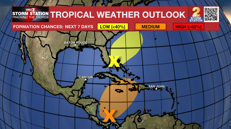
The Tropics: Disorganized showers and thunderstorms persist in association with a trough of low pressure located in the southwestern Caribbean Sea. Environmental conditions appear marginally conducive for development of this system over the next couple of days, and a tropical depression could form by this weekend as the system starts moving northeastward across the western and central part of the Caribbean Sea. An Air Force Reserve reconnaissance mission is scheduled to investigate the system tomorrow.
A non-tropical area of low pressure is expected to form near southern Florida along a frontal boundary by tomorrow. This system is then forecast to move quickly northeastward across the Bahamas and offshore of the east coast of the U.S. through the weekend. Although development into a tropical cyclone appears unlikely, this system is expected to produce gusty winds and heavy rains across portions of southern Florida, the Florida Keys, and the Bahamas during the next couple of days.
– Josh
The Storm Station is here for you, on every platform. Your weather updates can be found on News 2, wbrz.com, and the WBRZ WX App on your Apple or Android device. Follow WBRZ Weather on Facebook and Twitter for even more weather updates while you are on the go.
More News
