

Latest Weather Blog
Wednesday AM Forecast: Warming trend continues with addition of daily rain chances
Warmer afternoons for the remainder of the week are paired with the chance to run into showers and storms. The greatest coverage of storms are expected Friday and Sunday.
Tonight & Tomorrow: Temperatures across southern Louisiana early Wednesday will be around 15° warmer than 24 hours prior. Baton Rouge will see temperatures bottom out near 60° early Wednesday before quickly warming after sunrise. Afternoon highs will flirt with the 80 degree mark in the Capital Area. Additional moisture being brought in from the gulf thanks to southeasterly winds today brings mostly cloudy skies and allows for spotty shower and thunderstorm development, especially during the afternoon today.
Not everyone will see rain and coverage of showers will be close to none once the sun sets. The mostly cloudy conditions will remain overnight tonight, keeping the warming trend going. Thursday morning temperatures will only drop into the upper-60's.
Up Next: Thursday will be very similar to today. After a mild start early tomorrow morning, temperatures will return to the 80s in the afternoon, which will also carry a chance for isolated showers and storms. The greatest coverage and chance to run into storms arrives on Friday, as a cold front approaches the area. By Friday, the atmosphere will contain plenty of moisture to support scattered to numerous showers and some stronger storms could development. Friday will be a day to closely monitor the radar before participating in outdoor activities, although there will be periods of dry time during the day.
Trending News
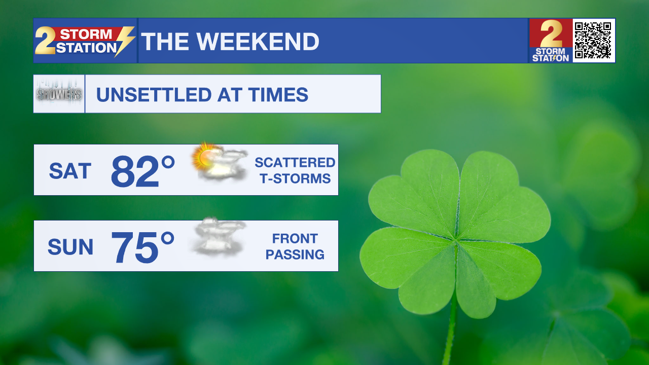
Saturday continues to trend to be the driest of the two weekend days, good news for those running in the Shamrock 5k or attending the Wearin' of the Green Parade! Temperatures Saturday will start off mild, in the upper 60s, and warm to the low 80s later that afternoon. As the cold front that brings storms on Friday stalls out over the state, we cannot rule out isolated storms, especially during the afternoon and evening.
Finally, during the day on Sunday, the cold front will slowly exit the state. As it moves out, scattered showers and some stronger storms along the front will develop. Once it clears the Capital region, we will begin to see a push of cooler and drier air invade the state from the northwest. Next week will start off below average with afternoon temperatures in the 60s.
Get the latest 7-day forecast and real time weather updates HERE.
Watch live news HERE.
– Emma Kate Cowan
The Storm Station is here for you, on every platform. Your weather updates can be found on News 2, wbrz.com, and the WBRZ WX App on your Apple or Android device. Follow WBRZ Weather on Facebook and Twitter for even more weather updates while you are on the go.
More News
