

Latest Weather Blog
Wednesday AM Forecast: Unseasonably warm for now; Big pattern changes leading up to Halloween
Fortunately, fog is much less of a concern for the Wednesday morning commute. We’re left with warm and breezy conditions for the rest of the day. That's a theme which remains through the weekend. That said, a cold front is on the horizon which appears to bring a big pattern change just in time for Halloween.
Today & Tonight: Slightly higher winds speeds have helped limit areas of dense fog early Wednesday. Aside from a few low clouds here and there, most are waking up to mostly sunny skies. We’ll see mostly sunny skies turn partly sunny as the day wears on. It’ll remain well above average with highs in the upper-80s along with an east/southeast breeze. We can’t rule out a spotty shower or sprinkle arriving from the southeast during the afternoon. Chances of seeing those, however, are very slim. We’ll otherwise be mostly clear into Wednesday night with a low in the upper-60s.
Up Next: Very little changes are expected for the remainder of the workweek and into the weekend. High temperatures will be in the upper-80s each day, which is about 10° above average. On some days, our forecast highs come within a few degrees of record highs. During the nighttime, we’ll continue to monitor the fog potential – which will likely be closely tied to how calm wind speeds are.
By Monday, a strong cold front appears to pass through the region. The latest data suggest that there could be a few showers as the front passes through. Colder air rushes in just ahead of Halloween behind the front. It could be a chilly evening for the trick-or-treaters!
Get the latest 7-day forecast and real time weather updates HERE.
Trending News
Watch live news HERE.
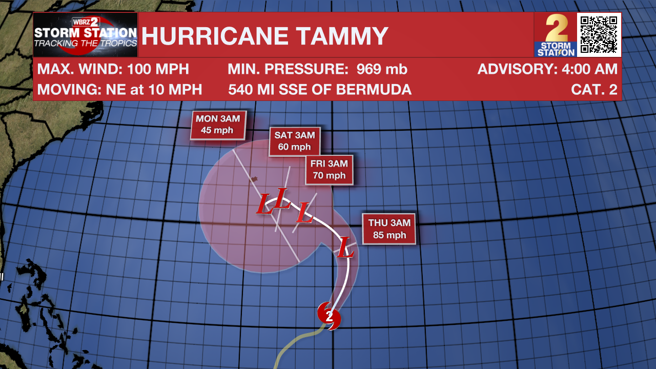
The Tropics: Hurricane Tammy became a Category 2 hurricane overnight Monday with maximum winds at 100 mph. While Tammy may briefly intensify in the near-term, the storm will gradually weaken as it takes a northwest turn later in the week. The forward motion of Tammy will slow over the weekend and likely become post-tropical. Nevertheless, the system ventures closer to Bermuda. Bermuda will need to be on the lookout for high swells, rain, and high winds this weekend and early next week.
-Meteorologist Malcolm Byron
The Storm Station is here for you, on every platform. Your weather updates can be found on News 2, wbrz.com, and the WBRZ WX App on your Apple or Android device. Follow WBRZ Weather on Facebook and Twitter for even more weather updates while you are on the go.
More News
