

Latest Weather Blog
Wednesday AM Forecast: Numerous rain showers across the boot today
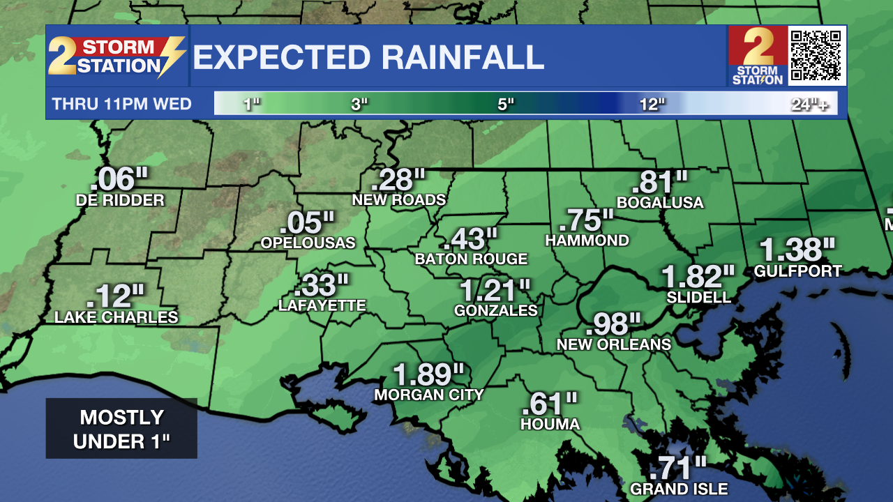
Rain showers are expected around the state today. Areas near Gonzales and Morgan City could see the greatest amounts of rainfall.
Today & Tonight: As you head out the door this morning, make sure to grab your umbrella. Rain showers that began overnight will continue throughout the day today. Rain coverage will increase through the morning, which could possibly impact your morning commute. Periods of rain will continue into the afternoon. The wind will kick up also, with northeast breezes of 10-15mph and gusts up to 30mph possible. Afternoon temperatures will be closely tied to any rainfall. Should a soggier solution pan out, temperatures will struggle to reach 70°. However, temperatures might try to recover into the 70s during drier periods. Unfortunately, this does not look like a drought-busting rain event. Most are looking at totals under 1”, with higher amounts closer to the coast.
Overnight, rain chances decline and we will be left with temperatures that barely decrease into the lower 60s with clouds sticking around.
Up Next: The rain coverage backs off considerably on Thursday and Friday with a 10-20% chance of rain each of those days. Aside from the small rain chance, we’ll otherwise be dry to close out the workweek with highs climbing back into the 80s. Another cold front is set to arrive sometime Friday night. This will send both temperatures and humidity dropping into the weekend. This upcoming weekend will feel very similar to last weekend. We also expect the comfortable weekend weather to continue into the workweek.
Trending News
Get the latest 7-day forecast and real time weather updates HERE.
Watch live news HERE.
The Tropics:
As of early Wednesday morning, now tropical storm Sean is moving toward the west-northwest near 13 mph (20 km/h). A west-northwestward to northwestward motion is forecast during the next few days. Satellite intensity estimates indicate that the maximum sustained winds are near 40 mph (65 km/h) with higher gusts. Little net change in strength is forecast during the next 72 hours. At this time, Sean posses no threat to Louisiana.
.png)
A tropical wave just offshore of west Africa is producing a large area of disorganized showers and thunderstorms. Some gradual development of this system is possible over the next several days while the wave moves westward across the eastern and central tropical Atlantic. It has a 20% chance of development over the next 7 days.
.png)
-- Emma Kate Cowan
The Storm Station is here for you, on every platform. Your weather updates can be found on News 2, wbrz.com, and the WBRZ WX App on your Apple or Android device. Follow WBRZ Weather on Facebook and Twitter for even more weather updates while you are on the go.
More News
