

Latest Weather Blog
Wednesday AM Forecast: Fall is right around the corner but fall-like temperatures, not so much
With the official first day of astronomical fall coming up on Saturday, we have been watching for any signs of a season change forecast wise. As for the next 7 days, temperatures won't budge from the above average range in the lower 90s. However, the drier air we have had all week is more seasonable to our fall months and is a nice reminder of how comfortable air can feel as a very steamy summer in Louisiana comes to an end.
Today & Tonight: Today temperatures will once again rise into the lower 90s motivated by the mostly sunny skies and dry, lower humidity conditions. Rain chances remain extremely unlikely throughout the day. Overnight, temperatures will fall into the upper 60s, not quite as cool as we’ve seen the past few days, and the sky will remain mostly clear.
Up Next: For the end of the workweek and start of your weekend, expect highs in the low to mid 90s. Low temperatures will be in the mid to upper 60s through Thursday, with low 70s beyond that. At that time, humidity will begin to creep up but not back to peak summer levels. Without a ton of humidity and no major storm systems passing through, the forecast also looks completely dry for the rest of the workweek. There are some early signs that enough moisture will arrive in the atmosphere to support a shower or thunderstorms by the weekend. Slightly better, albeit low, rain chances will be possible as a weak cold front approaches the area on Monday and Tuesday.
Trending News
Get the latest 7-day forecast and real time weather updates HERE.
Watch live news HERE.
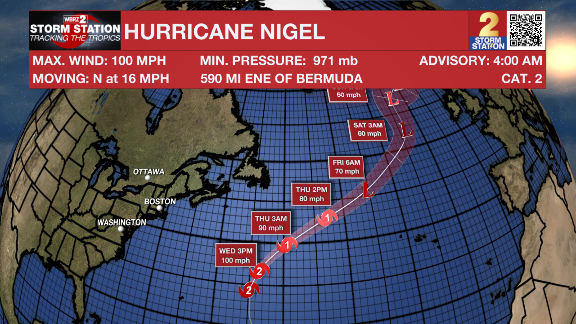
The Tropics: Hurricane Nigel continues to strengthen over the central Atlantic Ocean. With maximum sustained winds of 100mph, the storm is moving northwest at 10-15mph. Nigel will turn north by Wednesday and accelerate northeast through the rest of the week. The storm will turn post-tropical by the end of the week. The only potential threat to land are high swells near Bermuda.
A tropical wave is expected to move off the west coast of Africa by Wednesday. Environmental conditions are forecast to be conducive for gradual development of the wave thereafter, and a there is a seventy percent chance that a tropical depression forms late this week or this weekend while the system moves generally westward across the eastern and central tropical Atlantic.
A non-tropical area of low pressure is expected to form east of the Florida peninsula late this week. This system could acquire some subtropical characteristics this weekend while it moves generally northward. Regardless of subtropical development, this low is likely to bring gusty winds, heavy rain, and high surf conditions to portions of the coastal Carolinas into the coastal Mid-Atlantic states late this week into this weekend.
– Emma Kate Cowan
The Storm Station is here for you, on every platform. Your weather updates can be found on News 2, wbrz.com, and the WBRZ WX App on your Apple or Android device. Follow WBRZ Weather on Facebook and Twitter for even more weather updates while you are on the go.
More News
