

Latest Weather Blog
Tuesday PM Forecast: winds ease fog threat overnight, big pattern change before Halloween
Periods of fog and above average temperatures will be the theme through this weekend. A cold front will bring a big pattern change just before Halloween.
Tonight & Tomorrow: A few clouds will be around during the overnight hours. As low temperatures drop to meet dew point temperatures in the mid to upper 60s, air will become saturated. Unlike previous nights, a little bit more wind is expected and this should limit widespread, dense fog to a low cloud deck instead. After sunrise, temperatures will warm away from the dew points, humidity will decrease and clouds will start to erode giving way to partly sunny skies. There is an outside shot at a brief, light shower but just about all will stay dry. It will remain well above average with high temperatures in the upper 80s.
Up Next: Very little change is expected for the remainder of the week and the weekend. Beneath mostly sunny skies, high temperatures will continue soaring into the upper 80s and low temperatures will be in the upper 60s. While these numbers check in around 10 degrees above average, no record highs are explicitly forecast to fall. As for nights, low clouds should win out in most cases, however, with plenty of moisture in the air, wind will need to be monitored on a day-to-day basis as any calming will result in episodes of fog. A strong cold front is expected to roll into the region on Monday. If the current trend holds, some showers will move through and much cooler air will arrive just ahead of Halloween. Following that next front, highs will return to the upper 60s and low 70s with lows in the upper 40s and low 50s.
Get the latest 7-day forecast and real time weather updates HERE.
Watch live news HERE.
Trending News
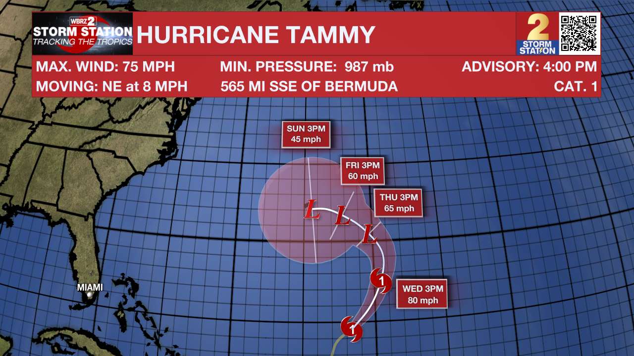
The Tropics: Hurricane Tammy will continue to move northeast across the southwestern Atlantic Ocean at 8-12mph through Wednesday with a slower motion as it turns to the northwest later in the week. Tammy may strengthen a bit before steadily weakening. Bermuda will be on the lookout for high swells, rain and wind closer to the weekend.
– Josh
The Storm Station is here for you, on every platform. Your weather updates can be found on News 2, wbrz.com, and the WBRZ WX App on your Apple or Android device. Follow WBRZ Weather on Facebook and Twitter for even more weather updates while you are on the go.
More News
