

Latest Weather Blog
Tuesday PM Forecast: some sun and warmth ahead of rain late Thursday
Clouds were much thicker and more persistent than expected on Tuesday. Wednesday will reveal more sunshine and warmer temperatures before wet weather returns on Thanksgiving.
Next 24 Hours: Mostly cloudy skies will continue through the night. Low temperatures will stop in the upper 40s with generally calm winds. A warming trend will continue Wednesday as high temperatures take a run at 70s degrees in response to mostly sunny skies.
Up Next: Clouds will increase into Thanksgiving. A slow moving storm system will develop over the Lower Midwest and spread rain eastward across the Mississippi River Valley to end the week.
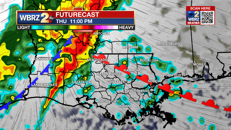
Expect precipitation to develop later on Thanksgiving after a high temperatures in the low 70s. Periods of rain will be possible right through Friday. This system will deliver a healthy soak to the region with widespread rain totals of 2-3 inches. It is still too early to tell if the associated cold front will be progressive enough to kick out moisture on Friday evening, or if there will be some showers lasting into the weekend. Once the front does pass, thermometers will only take a minor dip. CLICK HERE for your detailed 7-Day Forecast.
Trending News
The Tropics: For the North Atlantic, Caribbean Sea and Gulf of Mexico, all is quiet. No tropical development is expected over the next five days.
The Explanation: Into Wednesday, clouds will depart early revealing mostly clear skies and highs will easily climb into the upper 60s or even lower 70s. Wednesday night, focus shifts back to our west as a deep upper level trough of low pressure digs into the Mountain West. This trough will move into New Mexico and Texas, cutting off from the upper level steering winds on Wednesday night. What this means at the surface is a bit challenging. This trough should set the stage for increasing mid-level southwest wind flow pumping moisture into the region through Thursday morning. As that occurs, rain will develop and overspread the area into the afternoon hours on Thanksgiving and continue overnight. If the local area remains in the warm sector, temperatures will stay mild for one more day. Depending on the eventual track of an associated surface low, there may even be a window of opportunity for severe weather, but it is too early for details in that regard. This system will eject east by Saturday as the upper level low de-amplifies and gets picked up by a weak kicker trough over the northern Great Lakes. Behind that system, surface high pressure builds in, so conditions quickly dry out and slightly cool down with highs returning to the upper 60s and low 70s Sunday and Monday.
--Josh
The Storm Station is here for you, on every platform. Your weather updates can be found on News 2, wbrz.com, and the WBRZ WX App on your Apple or Android device. Follow WBRZ Weather on Facebook and Twitter for even more weather updates while you are on the go.
More News
