

Latest Weather Blog
Tuesday evening forecast: cold front on track, something to see in skies tonight
On Monday, the Capital Area broke yet another heat record in a year which already essentially owns the history books. The high temperature went above 90 degrees for a record breaking 135th time. By the end of Thursday, a few more may be added to that count before a significant cold front arrives.
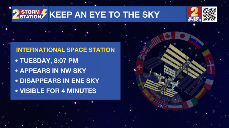
Tonight & Tomorrow: A few more clouds developed on Tuesday afternoon but those should start to fall apart rather quickly after sunset. A quick look up around 8:17pm will allow a glimpse of the International Space Station in the northwest sky. It will be visible for approximately five minutes before disappearing into the eastern sky. Low temperatures will settle in the upper 60s. High temperatures will then race into the low 90s on Wednesday afternoon, continuing the abnormally hot conditions for the time of year. Skies will remain mostly sunny.
Up Next: After one more afternoon into the low 90s, the first noteworthy cold front of the fall season will begin to press into the Gulf Coast region on Thursday. This front will be running into drier air locally and so a line and showers and thunderstorms is expected to be weakening on approach with only isolated activity making it into the area late into the afternoon and evening. As a secondary front swings in from the north, moisture pooling along the original front may aid in the development of a few more showers and thunderstorms, especially early on Friday. After a muggy start to Friday, humidity will gradually drop through the end of the workweek with major changes felt by the weekend. Saturday will begin with lows in the mid 60s followed by highs in the mid 80s, despite sunshine. The coolest temperatures so far this season are anticipated on Sunday and Monday morning with lows in the low to mid 50s and highs barely returning to the upper 70s and low 80s. With these changing temperatures breaking a long spell of warmth, you may need to consider a light jacket for morning and evening activities this weekend.
Trending News

Get the latest 7-day forecast and real time weather updates HERE.
Watch live news HERE.
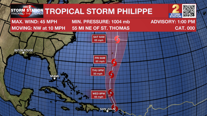
The Tropics: Tropical Storm Philippe is passing by the British Virgin Islands and remains poorly organized with maximum sustained winds of 45mph. Moving to the northwest at 10mph, the system is expected to turn more due north on Wednesday and away from the islands. Some slight strengthening could come over open water later in the week.
– Josh
The Storm Station is here for you, on every platform. Your weather updates can be found on News 2, wbrz.com, and the WBRZ WX App on your Apple or Android device. Follow WBRZ Weather on Facebook and Twitter for even more weather updates while you are on the go.
More News
