

Latest Weather Blog
Thursday PM Forecast: Record breaking temperatures continue, rain could start to increase next week
Dangerous, record breaking heat will be possible for the rest of the week and into the weekend. However, some changes could be coming next week.
An ***EXCESSIVE HEAT WARNING*** is in effect until 7pm tomorrow for the entire WBRZ Viewing Area. Dangerously hot conditions with heat index values up to 114 expected. Extreme heat and humidity will significantly increase the potential for heat related illnesses, particularly for those working or participating in outdoor activities. Drink plenty of fluids, stay in an air-conditioned room, stay out of the sun, and check up on relatives and neighbors. Young children and pets should never be left unattended in vehicles under any circumstances. Take extra precautions if you work or spend time outside. When possible reschedule strenuous activities to early morning or evening. Know the signs and symptoms of heat exhaustion and heat stroke. Wear lightweight and loose fitting clothing when possible. To reduce risk during outdoor work, the Occupational Safety and Health Administration recommends scheduling frequent rest breaks in shaded or air conditioned environments. Anyone overcome by heat should be moved to a cool and shaded location.
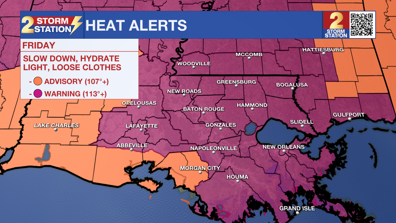
Tonight & Tomorrow: Partly cloudy skies this evening will give way to mainly clear skies tonight. Low temperatures will stay well above average, only dropping into the upper 70s. On Friday, temperatures will climb to near 102 degrees, beneath mostly sunny skies. Feels like temperatures, because of high humidity, will climb to near 114 degrees. Rain will be hard to come by but can not rule out a spotty shower.
Trending News
Up Next: Record breaking heat will continue to be the story for the rest of the week and this weekend. Every afternoon, highs are expected to be at or above 100 degrees. Feels like temperatures could be near 113 degrees each and every day. It will be hard to cool off at night with low temperatures staying in the 80s. Rain chances stay slim on Saturday but could slowly start to increase on Sunday and Monday. A significant pattern change will occur starting Tuesday with rain becoming much more likely and high temperatures finally cooling down a bit, but should still be well above average.
Get the latest 7-day forecast and real time weather updates HERE.
Watch live news HERE.
The Tropics: Tropical cyclone activity is not expected in the next 7 days.
--Balin
The Storm Station is here for you, on every platform. Your weather updates can be found on News 2, wbrz.com, and the WBRZ WX App on your Apple or Android device. Follow WBRZ Weather on Facebook and Twitter for even more weather updates while you are on the go.
More News
