

Latest Weather Blog
Thursday PM Forecast: rain and thunderstorms around for morning drive
Be prepared for some wet weather on the final morning commute of the workweek. Outdoor plans are not in danger of being washed out over the weekend.
Tonight & Tomorrow: Mainly cloudy skies will persist well into the evening. After midnight we will see coverage of showers and thunderstorms increase from the southwest. Rain will pull temperatures down int the low 50s. For the Friday morning commute, scattered showers and thunderstorms will result in some slick and slow spots on the roads. It should not be a constant rain areawide though; there will be some dry areas. 2une In to WBRZ from 5-7am for a check of the radar or stay ahead of the rain by downloading the free Storm Station weather app HERE. Precipitation will taper in coverage and intensity through the day. However, skies will stay mainly cloudy. Where a peek of sunshine occurs, some upper 60s are possible. Otherwise, high temperatures will keep to the mid 60s.
Up Next: The weekend will begin with temperatures in the mid 50s, low clouds and fog. A weak disturbance moving across the region may interact with a stalled front near the coast to create spotty to isolated showers and thunderstorms. Some sun will become available by afternoon helping high temperatures into the mid 70s. Coincident with that daytime warming, a spotty shower or thunderstorm will remain possible on Saturday. Sunday will see similar weather with the exception being slightly warmer temperatures with lows in the low 60s and highs in the low 80s. While most of the day, and weekend, will be dry, a spotty shower or thunderstorm should not take you by surprise at any outdoor events.
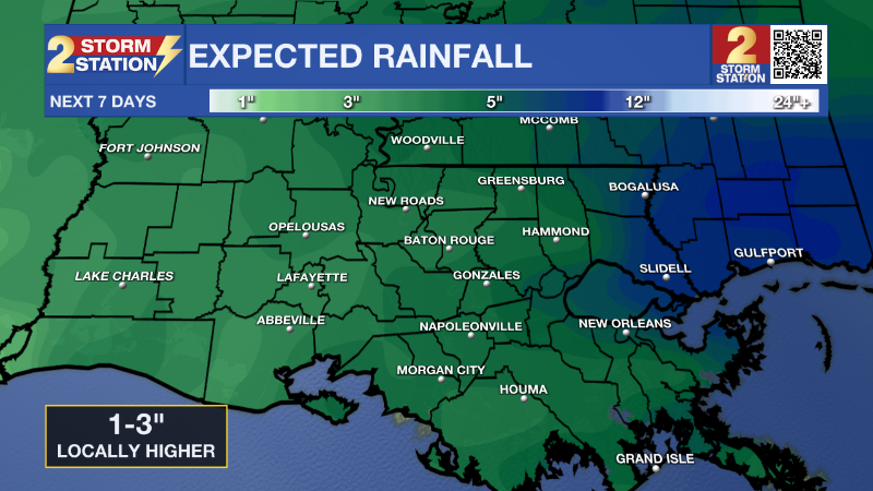
The first full week of March will bring more opportunities for rain around the central Gulf Coast. Another cold front will move in early next week but timing of this system remains uncertain. As of now, showers and thunderstorms appear most likely late Monday through early Tuesday, though that timeline may be shifted or even narrowed as we get closer. By the time that batch of precipitation ends, 1-3” of rain is expected. An unsettled pattern may persist through much of next week with more chances for showers and thunderstorms.
Trending News
Get the latest 7-day forecast and real time weather updates HERE.
Watch live news HERE.
– Josh
The Storm Station is here for you, on every platform. Your weather updates can be found on News 2, wbrz.com, and the WBRZ WX App on your Apple or Android device. Follow WBRZ Weather on Facebook and Twitter for even more weather updates while you are on the go.
More News
