

Latest Weather Blog
Thursday PM Forecast: cooler, drier air just over a day away
After a few showers on Thursday, much cooler air will move in as the workweek ends and the weekend begins. Forecast temperatures have been adjusted down and it is possible some will see the lowest readings since late April.
Tonight & Tomorrow: Alas, a much awaited cold front has pushed into the region. The slow mover will allow a continued chance for isolated showers overnight. Skies will remain mainly cloudy otherwise. The temperature changes will take some time and lows will stay in the upper 60s and low 70s. On Friday, a secondary front will swing in from the north. Just enough leftover moisture may aid in the development of stray showers. The workweek will end a bit muggy, with highs in the upper 80s.
Up Next: The second front and accompanying cooler air will race through to begin the weekend. Saturday will start with lows in the low 60s followed by highs in the low 80s, despite mostly sunny skies. The coolest temperatures so far this season are anticipated on Sunday and Monday morning with lows in the upper 40s and low 50s and highs barely returning to the upper 70s and low 80s. With these changing temperatures breaking a long spell of warmth, you may need to consider a light jacket for morning and evening activities this weekend. Not much will be happening overhead other than some passing high clouds through Tuesday. By the middle of next week, the next storm system will be setting up to our west and could lead to some much needed rainfall toward the end of next week.
While the front will bring welcome heat relief and more comfortable air, the lower humidity and northerly winds will re-ignite fire weather concerns in the area. A RED FLAG WARNING has been issued for Saturday.
Trending News
Get the latest 7-day forecast and real time weather updates HERE.
Watch live news HERE.
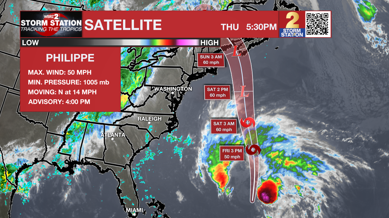
The Tropics: The outermost rain bands from Tropical Storm Philippe are affecting Bermuda where conditions will deteriorate into Friday. Philippe is producing maximum sustained winds of 50mph while moving north at 15mph. Some strengthening is possible before Philippe turns post tropical over the weekend and accelerates into the north Atlantic Ocean. The storm could bring a few inches of rain and gusty wind to parts of New England and southeastern Canada over the weekend.
A low-latitude tropical wave is expected to move off the west coast of Africa this weekend. Thereafter, some slow development of this system is possible as it moves westward to west northwestward across the eastern tropical Atlantic.
– Josh
The Storm Station is here for you, on every platform. Your weather updates can be found on News 2, wbrz.com, and the WBRZ WX App on your Apple or Android device. Follow WBRZ Weather on Facebook and Twitter for even more weather updates while you are on the go.
More News
