

Latest Weather Blog
Thursday AM Forecast: Increase in clouds, temperatures, and rain coverage over the next few days
Clouds are back today and tomorrow with an occasional spotty light rain shower. The Storm Station team is continuing to monitor this weekend's storm chances that could impact Mardi Gras parades.
Today & Tonight: An increase in cloud cover overnight kept temperatures in the mid-50s this morning, very mild for this time of year. The warming trend continues this afternoon despite the additional cloud cover with temperatures in the Capital Area expected in the mid-70s. Winds out of the southeast continue to pump additional moisture and warm air into the state over the next few days. Light spotty showers are possible today and overnight, but they will be light in nature and most will remain dry. Overnight tonight into early Friday, temperatures don't move much, a morning low of 61° is forecasted for Baton Rouge.
Up Next: Friday afternoon will see the warmest temperatures of the week, depending on cloud cover/sun that is able to peak through the clouds during the day, some areas could record temperatures in the low 80s! Spotty, light rain showers are possible on Friday but the weekend brings a greater chance for rain.
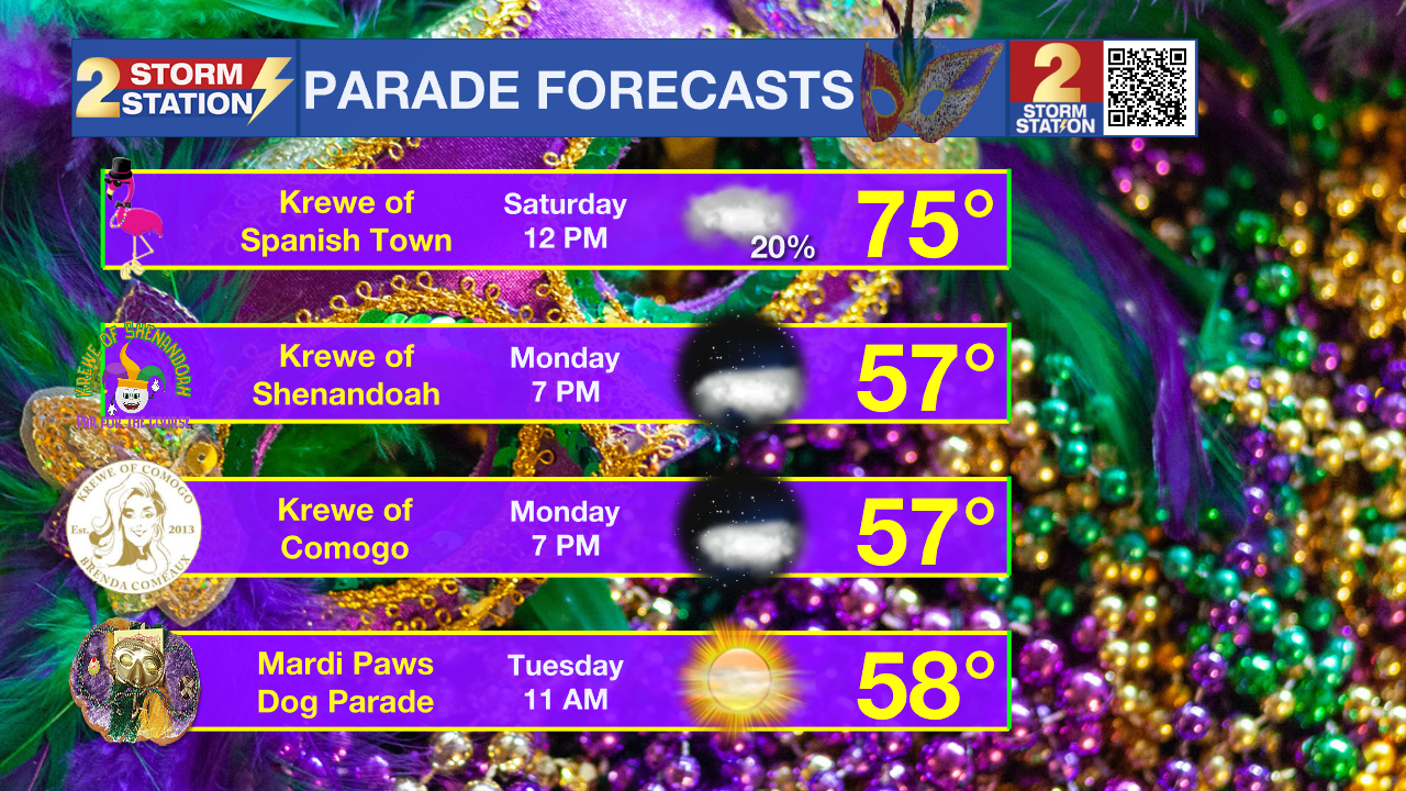
On Saturday, while isolated storms could move through the Capital Area, the majority of rain and storm activity stays to the north. Regardless of rain, skies stay overcast and afternoon temperatures will remain warm in the upper 70s. The rain activity shifts southeast during the evening hours and overnight Saturday into Sunday morning. Sunday brings numerous showers and storms from sun up to sun down and lightning within some storms could pose danger to anyone outside. Additionally, downpours could result in pockets of street and poor drainage flooding. By the time rain wraps up on Monday morning, about 1-3 inches will have fallen. Temperatures continue to trend above average in the 70s until the system passes early Monday morning.
By mid-day Monday, we should not only be much drier but could also see clearing in the skies. Behind the cold front that brings Sunday's rain, we will see a cool down as well. Next week's temperatures each afternoon will reside in the 60s and by Tuesday, Mardi Gras Day, we will have plenty of sunshine around the state.
Trending News
Get the latest 7-day forecast and real time weather updates HERE.
Watch live news HERE.
– Emma Kate Cowan
The Storm Station is here for you, on every platform. Your weather updates can be found on News 2, wbrz.com, and the WBRZ WX App on your Apple or Android device. Follow WBRZ Weather on Facebook and Twitter for even more weather updates while you are on the go.
More News
