

Latest Weather Blog
Thursday AM Forecast: Cold front brings changes for St. Patrick's Day weekend
As we head towards the big St. Patrick's Day weekend, a few rounds of showers and storms could impact your holiday plans. Numerous showers are expected, especially on Friday and Sunday.
Today & Tomorrow: Similar to Wednesday, Thursday will see plenty of cloud cover with occasional breaks for sunshine. Temperatures recorded in the mid to upper 60's early Thursday will rise to the mid-80's later in the day. Winds out of the south continue to usher in moisture from the gulf and mixed with daytime heating and a shortwave feature that will move through the state today, isolated showers and storms are possible this afternoon. Tonight, the warm weather continues as temperatures will only fall near 70° with cloudy skies.
Up Next: Friday remains warm and will see the greatest coverage of rain of the workweek. A cold front that moves towards the state during the day elevates atmospheric conditions to allow for the development of numerous showers and storms, especially late morning to late afternoon, with scattered activity into the evening. Any thunderstorms will be capable of producing heavy rain and gusty winds, potentially snarling traffic at times.
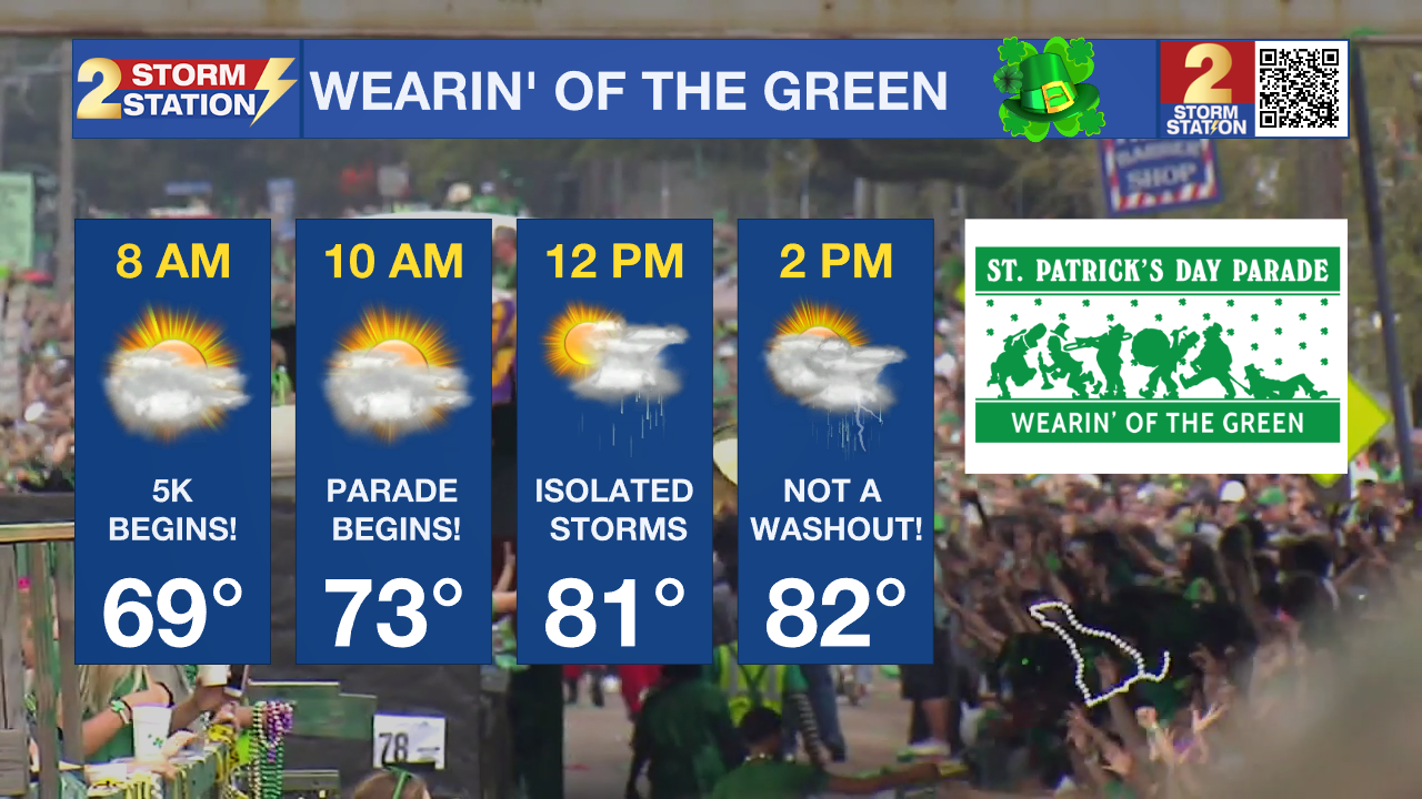
As the cold front stalls over the Capital region on Saturday, it keeps atmospheric conditions supportive of isolated shower and storm activity during the day, but plenty of dry time can be expected as well. While Saturday morning continues to trend mostly dry, it would encouraged for those running in the Shamrock 5k or heading out to the Wearin' of the Green parade to pack raingear incase you run into a nuisance shower. Most of the storms are likely during afternoon hours when daytime heating motivates isolated activity around southern Louisiana. Saturday will also be the warmest of the two weekend days, with afternoon temperatures in the low-80s.
Trending News
The cold front will slowly move out of the state during the day on Sunday bringing another round of numerous showers and thunderstorms. Some of the storms could become stronger, with gusty winds and heavier downpours possible. Keep a close eye on the radar if you have plans to head outdoors on St. Patrick's Day! Temperatures on Sunday will remain mild, in the 70's, but once the front exits to the east, northerly winds will take over and a push of cool and dry air will arrive to kickoff the workweek. The first half of next week will see temperatures a few degrees below average for the middle of March, typically sitting in the low 50s and upper 70s for lows and highs, respectfully.
Get the latest 7-day forecast and real time weather updates HERE.
Watch live news HERE.
– Emma Kate Cowan
The Storm Station is here for you, on every platform. Your weather updates can be found on News 2, wbrz.com, and the WBRZ WX App on your Apple or Android device. Follow WBRZ Weather on Facebook and Twitter for even more weather updates while you are on the go.
More News
