

Latest Weather Blog
Sunday PM Forecast: A big cooldown looking likely late this week
After a weekend with highs running about 10° above average (and even breaking a record on Saturday), temperatures will steadily decline over the upcoming week. That steady drop in temperatures will be followed by a more dramatic cooldown into next weekend as our first fall cold front arrives.
Tonight & Tomorrow: While we expect a wave of high clouds to pass through overnight Sunday, skies will still be mostly clear overall. We’ll wake up to plenty of sunshine on Monday morning with a low temperature in the mid to upper-60s. We’ll continue the hot streak on Monday afternoon, although likely a few degrees cooler. We’ll make a run for 93° in the capital city with tolerable, if not comfortable, humidity. There aren’t any changes to the rain forecast either. It will be another completely dry day on Monday.
Up Next: We’ll steadily scale back on high temperatures through much of the workweek. Even so, highs will still likely be in the 90s through at least Thursday. That said, changes arrive on Thursday night in the form of a cold front. There’s a chance to see some showers along the front. We are still erring on the lower side of things and putting a 20% rain coverage for Thursday and Friday. This is because there are still some question marks regarding rain chances late this week.
However, we’re much more confident in a cooldown associated with the front. Highs should drop back into the 80s on Friday. In fact, a second push of cooler/drier air arrives on Friday night, dropping temperatures even more for the weekend. By Sunday morning, we could see lows in the mid-50s and highs in the lower-80s.
Get the latest 7-day forecast and real time weather updates HERE.
Trending News
Watch live news HERE.
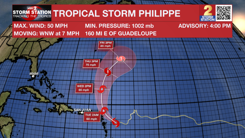
The Tropics: Philippe and Rina are still ongoing in the Atlantic as of 4pm Sunday. However, Rina has weakened to a tropical depression. Rina is on the verge of becoming post-tropical and will likely fizzle out overnight and into Monday morning.
On the other hand, Philippe remains a tropical storm with maximum winds at 50 mph. The storm will move northwest over the next 48 hours, skirting the northern Leeward Islands in the process. Tropical Storm Watches are in effect for the islands of Antigua and Barbuda where tropical storm force winds, heavy rain, and flash flooding are possible. Philippe will then continue to move north and perhaps strengthen into a hurricane by late week as it curves out to sea.
-- Meteorologist Malcolm Byron
The Storm Station is here for you, on every platform. Your weather updates can be found on News 2, wbrz.com, and the WBRZ WX App on your Apple or Android device. Follow WBRZ Weather
More News
