

Latest Weather Blog
Sunday AM Forecast: Quiet weather today, severe storms possible tomorrow
UPDATE - 12:20 p.m. Sunday: The Storm Prediction Center has upgraded portions of southeast Louisiana, including Baton Rouge, to a Level 3/5 risk for severe weather. Scattered severe weather will be possible with storms that pass through on Monday. The strongest storms arrive after dark, and the threat appears to diminish after midnight. The primary concerns are thunderstorm winds in excess of 60 mph, a few tornadoes, and isolated large hail.
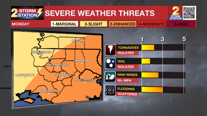
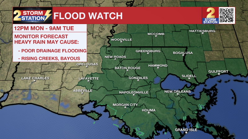
The severe weather threat is in addition to the high wind potential outside of storms along with heavy rain. A Flood Watch is in effect for the entire capital area from 12 p.m. Monday through 9 a.m. Tuesday. 2-4" of rain is possible, with locally higher amounts.
Aside from the new updates, the original story remains unchanged.
-- Meteorologist Malcolm Byron
ORIGINAL STORY: The weather will stay quiet today before our next storm system arrives tomorrow. These storms will have the possibility of being severe, especially after dark.
Trending News
Today & Tonight: Highs today will top out in the lower 60's. Clouds will stay minimal through most of the day, with the only clouds being some high clouds. These will begin to increase in coverage later in the day. Tonight, cloud cover will start to increase even more. We should still stay mainly dry overnight. Lows will bottom out in the lower 40's.
Up Next: Our next storm system will arrive on Monday. Rain could begin as early as the mid-morning. Showers and thunderstorms will be likely throughout the day and into the overnight hours. Rain amounts of 2-4 inches will be possible.
Severe weather will be possible, especially after dark. The highest threats look to be damaging winds and hail, with tornadoes being a slightly lower threat. There still some uncertainty in the exact magnitude of severe weather. Regardless, environmental conditions look favorable for isolated severe thunderstorms.
Another potential hazard will be strong winds outside of thunderstorms. Winds 26-35 mph with gust up to 50 mph will be possible. Make sure you secure any loose outdoor objects.
Some spotty showers will be possible early Tuesday morning but clearing skies are anticipated throughout the rest of the day. Near freezing temperatures will be possible again by Wednesday morning. The wet pattern looks like it will not let up, as rain chances will go up once again on Friday.
Get the latest 7-day forecast and real time weather updates HERE.
Watch live news HERE.
– Balin
The Storm Station is here for you, on every platform. Your weather updates can be found on News 2, wbrz.com, and the WBRZ WX App on your Apple or Android device. Follow WBRZ Weather on Facebook and Twitter for even more weather updates while you are on the go.
More News
