

Latest Weather Blog
Saturday PM Forecast: All time heat record for any date tied today, isolated rain chances early next week
Metro Airport tied its hottest all-time record by reaching 105 degrees Saturday evening. The last time Baton Rouge reached 105 degrees or higher was August 30, 2005.
Metro Airport records stretch back to 1930. Since then, there have been 77 days to reach 100 degrees or warmer. 22 of those days have occurred in 2023, which is the most in its history.
All-time Baton Rouge area records go back to 1892. Bringing in that database, 1921 takes the lead for most 100 degree days in a single year with 28. Additionally, in 1909 there was a 110 degree temperature recorded. However, the quality of that specific measurement is questionable due to a site failure just one day after the reading. Additionally, no surrounding locations were nearly as hot.
Either way, 105 degrees is the hottest modern temperature record in Baton Rouge history, and summer 2023 is cumulatively the hottest on record, for either database. The big reason for this has been the astonishing number of nights remaining above 80 degrees with 23 of them. The previous record was 4.
An ***HEAT ADVISORY*** is in effect from 10am-7pm tomorrow for the entire WBRZ Viewing Area. Dangerously hot conditions with heat index values up to 112 expected. Extreme heat and humidity will significantly increase the potential for heat related illnesses, particularly for those working or participating in outdoor activities. Drink plenty of fluids, stay in an air-conditioned room, stay out of the sun, and check up on relatives and neighbors.
Trending News
An ***AIR QUALITY ALERT*** is in effect until midnight tomorrow. The Air Quality Index indicates that ozone will be at the Orange level, which is unhealthy for sensitive groups. Increasing ozone levels may cause unhealthy air quality during afternoon hours. Active children and adults, the elderly, and people with respiratory diseases such as asthma should avoid prolonged outdoor exertion.
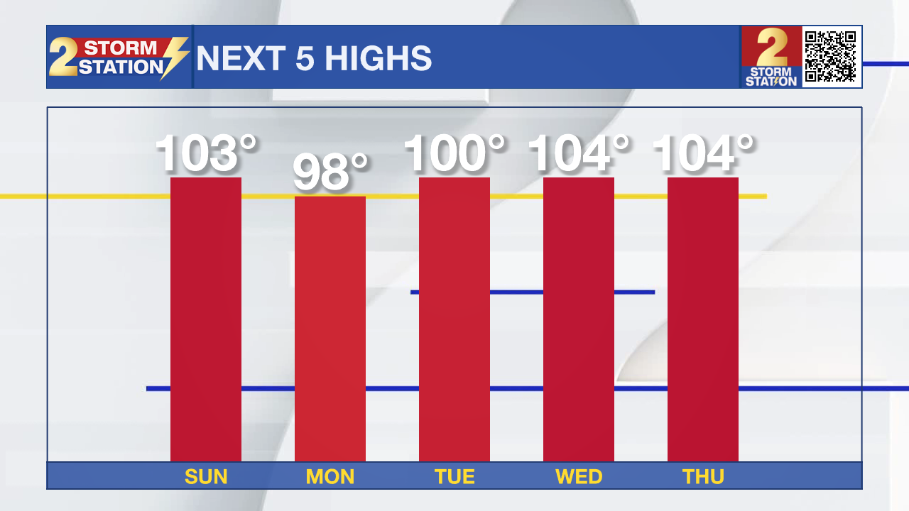
Tonight & Tomorrow: Tonight, temperatures will fail to leave the 80’s under clear skies. Tomorrow, another day of oppressive heat is likely with temperatures maxing out near 103 degrees under partly cloudy skies. Feels like temperatures because of high humidity could get to near 112 degrees! Spotty showers will be possible in the afternoon and evening but most areas will stay dry.
Up Next: Some rain will be possible Monday into Tuesday, but these days are unfortunately trending drier. Coastal areas have the best shot at rain on these days. Some of the warmest temperatures we have seen all summer will set in by the middle of next week. Some areas could potentially see highs near 104 degrees for multiple days in a row.
Get the latest 7-day forecast and real time weather updates HERE.
Watch live news HERE.
The Tropics:
- Eastern Tropical Atlantic (AL98): Showers and thunderstorms continue to show some signs of organization in association with a broad area of low pressure located a few hundred miles west of the Cabo Verde Islands. Environmental conditions appear generally favorable for additional development of this system, and a tropical depression is likely to form over the weekend while it moves toward the west-northwest or northwest at about 10 mph across the eastern tropical Atlantic. By early next week, upper-level winds over the system are forecast to increase, and further development is not expected.
- Central Tropical Atlantic (AL99): An elongated trough of low pressure located roughly halfway between the Cabo Verde Islands and the Lesser Antilles is producing some disorganized showers and thunderstorms. Environmental conditions are only marginally conducive for further development of this system, but a tropical depression could still form during the day or so while it moves west-northwestward at 10 to 15 mph across the central tropical Atlantic. Thereafter, upper-level winds are forecast to become unfavorable for any further development.
- East-Southeast of the Lesser Antilles: Another area of low pressure could form in a day or so from an elongated trough of low pressure located several hundred miles to the east-southeast of the Lesser Antilles. Some slow development of this system is possible over the weekend and into early next week as it moves generally west-northwestward at 10 to 15 mph across the Lesser Antilles and into the northeastern Caribbean Sea.
- Western Gulf of Mexico: An area of disturbed weather located over the southeastern Bahamas is forecast to move into the Gulf of Mexico by early next week, where a broad area of low pressure could form. Thereafter, some slow development of this system is possible and a tropical depression could form as it moves westward and approaches the western Gulf of Mexico coastline by the middle of next week.
--Balin
The Storm Station is here for you, on every platform. Your weather updates can be found on News 2, wbrz.com, and the WBRZ WX App on your Apple or Android device. Follow WBRZ Weather on Facebook and Twitter for even more weather updates while you are on the go.
More News
