

Latest Weather Blog
Monday PM Forecast: warm and windy week ahead
The weather story over the next several days will be warm temperatures. Some records could fall before the week is over.
Tonight & Tomorrow: Overnight will be cloudy and breezy with southwest winds of 10-15mph. Low temperatures will stop in the mid 60s, which is almost 20 degrees above average for the time of year. While mainly cloudy skies will persist for Mardi Gras, some breaks of sunshine are also expected, especially during the late morning and afternoon hours. Winds will continue to blow out of the southwest at 10-15mph with occasional gusts over 20mph. High temperatures will make to about 81 degrees in Baton Rouge. The warmest Mardi Gras on record in the Capital City was 83 degrees, met in 1917 and 1932.
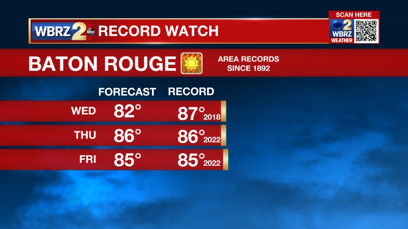
Up Next: Wednesday through Friday will be the warmest three day stretch of the forecast period. Again, high temperatures will top out in the low 80s on Wednesday. Late in the day, a weak front will approach from the northwest and could try to wring out an isolated shower north and west of the city, but widespread measurable rain is not likely. Thursday and Friday, a little more afternoon sun is expected and high temperatures will be running about 20 degrees above average. At 86 and 85 respectively, both Thursday and Friday are forecast to tie record highs set just one year ago. The overnight low temperatures will stay rather muggy too, in the mid to upper 60s through the shortened workweek.
Trending News
Get the latest 7-day forecast and real time weather updates HERE.
Watch live news HERE.
Detailed Forecast: A broad and anomalous upper level ridge of high pressure will anchor over the eastern Gulf of Mexico through the end of the week. This will cause well above average high and low temperatures, and largely shield the area from organized systems capable of producing rain. A little bit of fog could develop along the coast but will be maintained further inland as a low cloud deck because winds of 10-15mph will keep the surface air too mixed. Daytime warming will cause the layer of clouds to gradually evaporate and sunshine will bump high temperatures into the low 80s. A weak upper level trough of low pressure will move into the Plains States on Wednesday but stay far enough west that instability will likely remain too weak for organized showers and thunderstorms. However, the low will be strong enough to produce a tight pressure gradient with the surface high beneath the ridge in the Gulf to cause rather windy conditions on Wednesday. The sustained numbers may be more than 25mph with gusts up to 40mph possible. The ridge may reach peak intensity and proximity to the local area on Thursday and Friday leading to near record warmth. It is worth noting that if Baton Rouge reaches 88 degrees, it will tie the all-time warmest temperature on record in the month of February. A stalling front may try to sag southward Thursday night into Friday. While this feature will have little definition left, it could drop dew point temperatures by a few degrees into the weekend. More likely, the front will wash out north of our area and muggy conditions and above average temperatures will persist through the weekend.
--Josh
The Storm Station is here for you, on every platform. Your weather updates can be found on News 2, wbrz.com, and the WBRZ WX App on your Apple or Android device. Follow WBRZ Weather on Facebook and Twitter for even more weather updates while you are on the go.
More News
