

Latest Weather Blog
Increasing threat for flooding, strong storms tonight through Tuesday
A *FLOOD WATCH* is in effect for the entire Storm Station Forecast Area, except St. Mary Parish, through Tuesday evening. Excessive runoff may result in flooding of rivers, creeks, streams, and other low-lying and flood-prone locations. Flooding may occur in poor drainage and urban areas. Areas of thunderstorms over the next 24 hours could repeat over the same locations tonight and Tuesday. Rainfall totals of 3 to 6 inches, with locally higher amounts possible in some areas.
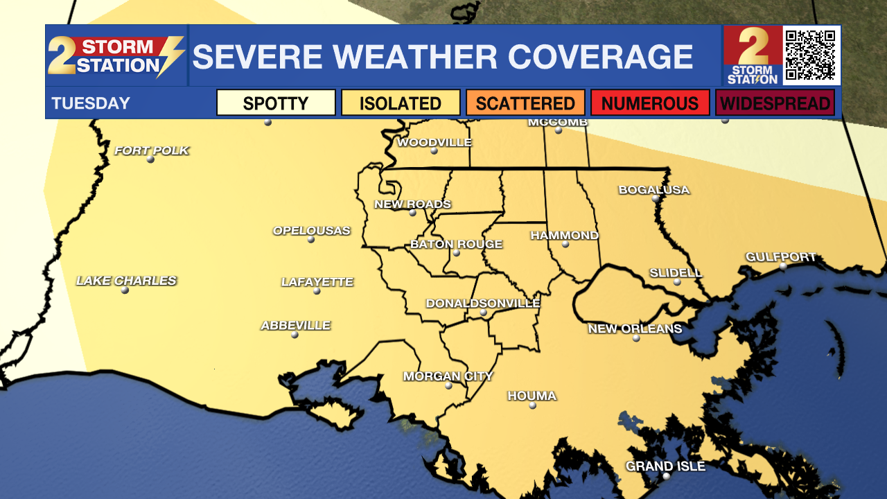
There is a *2/5 SLIGHT RISK* for severe weather on Tuesday. Thunderstorms will be capable of damaging wind, hail and torrential rain. Keep the Storm Station Weather App nearby to know of any thunderstorms or warnings for your area. Be sure to get to a sturdy structure nearby if one is issued.
A * HEAT ADVISORY* will be in effect across southeast Louisiana on Tuesday. This means heat index values could go up to 110 degrees. Hot temperatures and high humidity combined may cause heat illnesses to occur. Take extra precautions if you work or spend time outside. Drink plenty of fluids, wear lightweight and loose fitting clothing when possible. Young children and pets should never be left unattended in vehicles under any circumstances.
Tonight & Tomorrow: Some showers and thunderstorms are possible into the evening hours. Any of the storms could be strong and bring a period of heavy rainfall to a localized area. Lows will drift back into the upper 70s, especially where no rainfall occurs. While heat and humidity will still be a story on Tuesday, the duration of dangerously hot temperatures will be tapered by numerous showers and thunderstorms. The atmosphere will be ripe with energy and moisture so any thunderstorms could quickly turn severe with gusty wind and hail. Storms will also be capable of heavy bursts of rain over a short time. Stay weather aware.
Trending News
Up Next: A somewhat more typical summertime pattern is expected to evolve over the remainder of the workweek. It will still be plenty hot and humid with highs in the mid 90s and lows in the mid 70s. However, feels-like temperatures should drop below the advisory criteria of 107 degrees and afternoons will feature a few of those pop up showers and thunderstorms to cool off a few spots. There are some signs that the heat could gradually build again over the upcoming weekend.
Get the latest 7-day forecast and real time weather updates HERE.
Watch live news HERE.
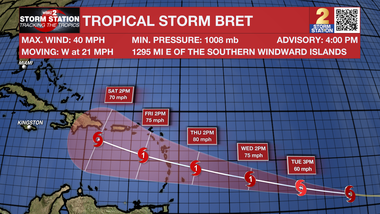
The Tropics: Tropical Storm Bret has formed over the central Atlantic. As of 4pm Monday, Bret was 1200 miles east of the Windward Islands and moving to the west at 21mph with maximum sustained winds of 40mph. Bret is expected to gradually strengthen over the next few days and could become a hurricane before the end of the week as it continues westward.
In the eastern Atlantic, a tropical wave located several hundred miles south-southwest of the Cabo Verde Islands continues to produce a large area of disorganized showers and thunderstorms. Environmental conditions appear favorable for further development of this system, and there is a fifty percent chance that a tropical depression could form in a couple of days while the system moves westward at 10 to 15 mph across the eastern and central tropical Atlantic.
--Josh
The Storm Station is here for you, on every platform. Your weather updates can be found on News 2, wbrz.com, and the WBRZ WX App on your Apple or Android device. Follow WBRZ Weather on Facebook and Twitter for even more weather updates while you are on the go.
More News
