

Latest Weather Blog
Monday PM Forecast: best shot at rain behind, but week still offers few small chances
Some parts of the viewing area, like Hammond, received a fast three to four inches of rain on Monday morning. While rain chances will taper through this workweek, a small opportunity will stay in the forecast. By the weekend, dry and warm conditions should prevail.
Tonight & Tomorrow: Some showers and thunderstorms may linger into the evening hours. Activity will slowly wane by midnight with a little clearing possible into daybreak. Low temperatures will bottom in the low 70s, keeping it rather muggy for the time of year. Skies will be partly sunny early Tuesday. High temperatures will be driven into the low 90s. By afternoon, isolated showers and thunderstorms will flare up to the tune of forty percent of the area collecting measurable rain.
Up Next: Wednesday will be partly sunny and considerably drier. A stray shower or thunderstorm will be possible, but most stay dry. As a result, high temperatures will climb a bit higher into the 90s. Look for a flip flop on Thursday with rain coverage bumping up just a touch. Friday through Monday are looking dry, however, this part of the forecast is a bit lower confidence than usual. As of now, afternoons are expected to be mostly sunny with highs in the low 90s with nights that are mostly clear with lows in the upper 60s. There are still no signs of a major cold front within the next seven to ten days.
Get the latest 7-day forecast and real time weather updates HERE.
Watch live news HERE.
Trending News
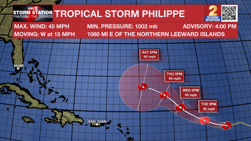
The Tropics: Tropical Storm Philippe has weakened a bit over the central Atlantic Ocean. With maximum sustained winds of 45mph, the storm is moving west at 15mph. The storm will slowly turn west-northwest over the next few days with little change in strength. At this time, Philippe poses no threat to land.
A tropical wave located several hundred miles west-southwest of the Cabo Verde Islands continues to produce disorganized showers and thunderstorms. Environmental conditions are forecast to be conducive for gradual development, and there is an eighty percent chance that a tropical depression will form within the next few days as the system moves west-northwestward across the central tropical Atlantic.
– Josh
The Storm Station is here for you, on every platform. Your weather updates can be found on News 2, wbrz.com, and the WBRZ WX App on your Apple or Android device. Follow WBRZ Weather on Facebook and Twitter for even more weather updates while you are on the go.
More News
