

Latest Weather Blog
Monday PM Forecast: beneficial rainfall as Idalia targets Florida
For the first time in more than ten days, no heat alerts are in effect on Tuesday. A weak front drifting through the region will trigger scattered showers and thunderstorms.
Tonight & Tomorrow: Leftover showers and thunderstorms may linger well beyond sunset since daytime warming is not the only agent responsible for development. A weak front will allow some activity to persist even past midnight. Low temperatures will slide back into the mid 70s. The front will continue to chug southeast on Tuesday but still have enough influence on the area to kick out scattered showers and thunderstorms, especially for Baton Rouge and points to the south and east. High temperatures will tick into the low 90s—very close to average for the time of year.
Up Next: Moisture will decrease on Wednesday and Thursday as the front moves offshore. We will feel lower humidity and seasonably warm temperatures that top out in the low to mid 90s. Additionally, winds will increase with Hurricane Idalia off to the southeast. The combination of increased winds and drier air, could result in increased fire danger. Recent rain just simply will not be enough to immediately break the drought conditions. There are signs that moisture may increase again next week for another period of needed showers and thunderstorms.
Get the latest 7-day forecast and real time weather updates HERE.
Watch live news HERE.
Trending News
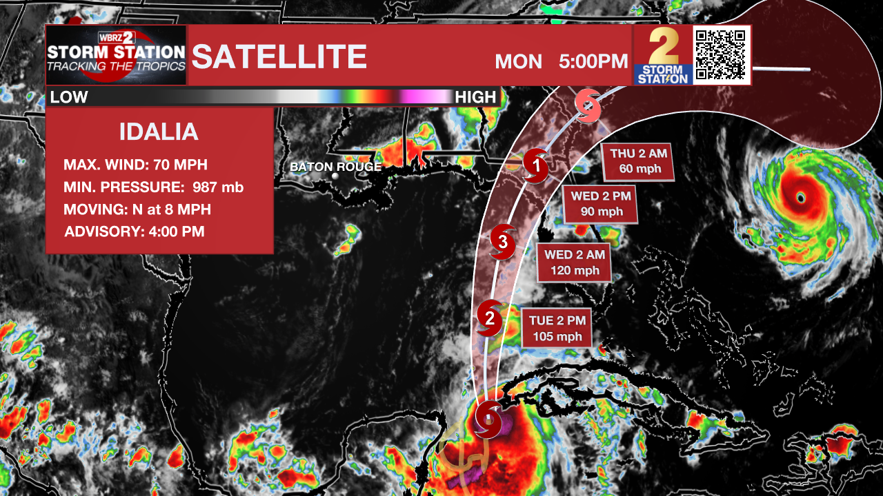
The Tropics: Idalia is on the verge of becoming a hurricane with maximum sustained winds of 70mph. The storm will intensify while moving across the eastern Gulf of Mexico on Tuesday and then make landfall, possibly as a major hurricane, near the Big Bend of Florida on Wednesday. Idalia is expected to produce storm surge of 8-12 feet near and east of the landfall site, with hurricane force winds across much of north, central Florida and rainfall of 5-10 inches for the Florida Panhandle, southeast Georgia and eastern Carolinas.
Hurricane Franklin is a powerful storm packing maximum sustained winds of 145mph. While it will produce dangerous rip currents along the United States East Coast and tropical storm conditions in Bermuda, a direct hit to land is not expected. Franklin will accelerate west of Bermuda and then northeast and out to sea later this week.
--Josh
The Storm Station is here for you, on every platform. Your weather updates can be found on News 2, wbrz.com, and the WBRZ WX App on your Apple or Android device. Follow WBRZ Weather on Facebook and Twitter for even more weather updates while you are on the go.
More News
