

Latest Weather Blog
Monday AM Forecast: even better rain chances, some could be heavy
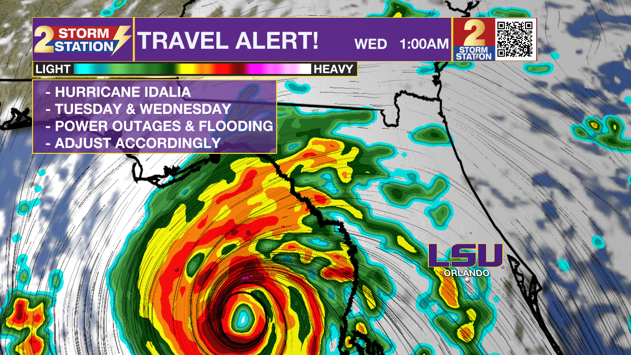
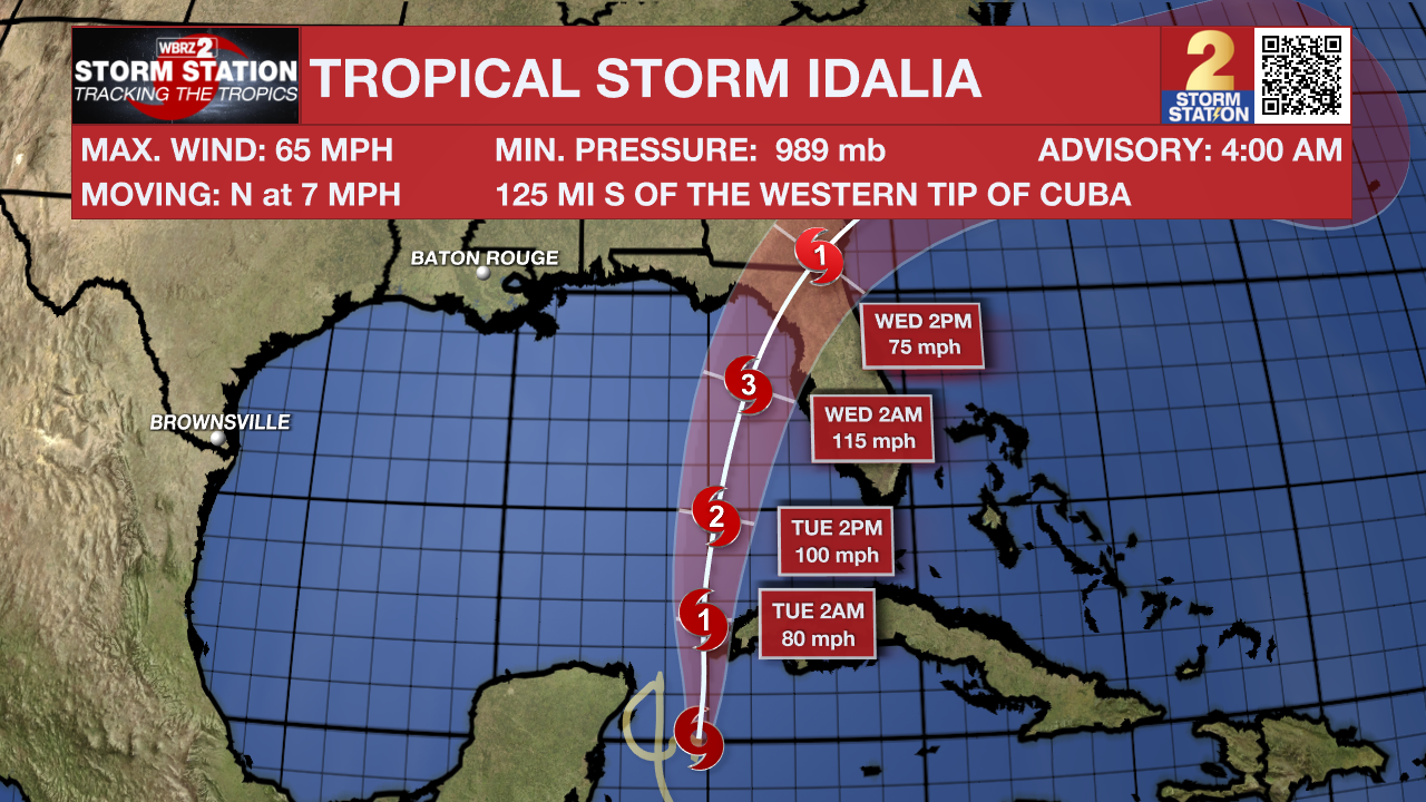
A weak cold front will deliver the best rain chance in quite some time for the Capital Area on Monday. Tropical Storm Idalia is expected to intensify and approach the Big Bend region of Florida during the middle of the week. Locally, dry air and breezy conditions created by the storm could bring fire danger.
A ***HEAT ADVISORY*** is in effect from 10am - 7pm on Monday for the entire WBRZ Viewing Area. Dangerously hot conditions with heat index values up to 112 are expected. Extreme heat and humidity will significantly increase the potential for heat related illnesses, particularly for those working or participating in outdoor activities. Drink plenty of fluids, stay in an air-conditioned room, stay out of the sun, and check up on relatives and neighbors.
The fire danger will be lower on Monday relative to previous days. However, critical conditions may develop once again later in the week.
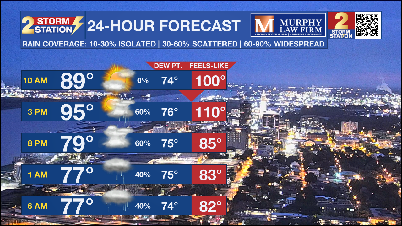
Today and Tonight: Monday, it will get hot once again but the heat will get cut short by the much needed return of rain. We still could get into the upper 90s with high humidity before any rain develops. High rainfall rates could happen in some storms, and a few areas could pick up an inch or more of rain. Due to the dry grounds, runoff could be an issue and some short fused poor drainage flooding is possible. While welcome, this rain will not be nearly enough to end the drought conditions. There is also a low end risk of severe storms with damaging winds being the primary concern.
Up Next: Some lingering showers will be possible Tuesday, but it should not be near the coverage as the day before. Temperatures will be way down and we could struggle to hit the mid 90s. By the middle and end of next week, temperatures will be in the mid and upper 90s, but humidity will be down. This drier air, coupled with winds on the northwestern side of Tropical Storm Idalia, could result in increased fire danger. After a few dry days, there is some early indication that moisture, and possibly more rain, will return to the area by next weekend.
Trending News
Get the latest 7-day forecast and real time weather updates HERE.
Watch live news HERE.
The Tropics:
Tropical Storm Idalia: This tropical system is forecast to enter the Gulf of Mexico and strengthen to a hurricane. Residents in Florida should continue to monitor this closely.
Hurricane Franklin: Franklin has strengthened into a Hurricane. It is forecast to become a major hurricane but it will stay out in the Atlantic. Residents in Bermuda need to monitor this system closely.
--Keller
The Storm Station is here for you, on every platform. Your weather updates can be found on News 2, wbrz.com, and the WBRZ WX App on your Apple or Android device. Follow WBRZ Weather on Facebook and Twitter for even more weather updates while you are on the go.
More News
