

Latest Weather Blog
FULL REPORT: 13 tornadoes confirmed by National Weather Service
The National Weather Service has confirmed that 13 tornadoes struck Southeast Louisiana and Southern Mississippi on Tuesday, February 23.
The following is their full report including final ratings, estimated winds, paths and a summary of damage findings. The report has not been altered with the exception of some format upgrades for wbrz.com. Photos have been added.
Note that tornado reports are ordered by time, beginning with the first.
Trending News
Public Information Statement
National Weather Service New Orleans/Baton Rouge, La.
9:57pm CST, Thu. Feb. 25 2016
NWS damage survey for 02/23/2016 tornado event
Overview: On Tuesday February 23, numerous severe thunderstorms affected Southeast Louisiana and Southern Mississippi. 13 tornadoes have been confirmed. This information is considered preliminary and may be subject to additional updates and corrections.
Tornado #1 – Jefferson Parish/Kenner
Rating: EF-0
Estimated peak wind: 80mph
Path length: 0.5 miles
Path width /maximum: 50 yards
Fatalities: 0
Injuries: 0
Start date: Feb. 23, 2016
Start time: 11:11am CST
Start location: Kenner
Start LAT/LON: 29.98 / -90.27
End date: Feb. 23, 2016
End time: 11:13am CST
End location: Kenner
End LAT/LON: 29.98 / -90.26
Survey Summary:
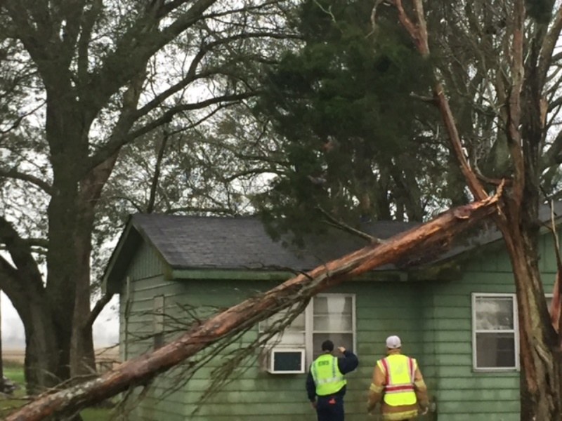
The tornado began near Audubon Court and Third Street just north of the Mississippi River. At this location a home lost some shingles and a braced power pole was down. The tornado continued northeast and removed a portion of the roof of a home, where winds were estimated at 80mph or EF-1 damage. Parts of other awning roofing tin had minor damage. A storage building and an elevated A/C unit were blown over on Morey Street. The tornado continued northeast and snapped a tree near Fortier Street and Pollock Plaza. No additional damage was found northeast of this point.
Tornado #2 - Iberville Parish/White Castle #1
Rating: EF-0
Estimated peak wind: 65mph
Path length: 3.3 miles
Path width /maximum: 50 yards
Fatalities: 0
Injuries: 0
Start date: Feb. 23, 2016
Start time: 11:20am CST
Start location: 3.4 S.W. of White Castle
Start LAT/LON: 30.1324 / -91.1811
End date: Feb. 23 2016
End time: 11:25 am CST
End location: 0.6 West of White Castle
End LAT/LON: 30.1751 / -91.1557
Survey Summary:
Intermittent damage along a 3.3 mile track was found. Damage consisted of peeled back tin roofs, damage to power lines, and downed large tree branches.
Tornado #3 - Ascension Parish/Prairieville
Rating: EF-0
Estimated peak wind: 80mph
Path length: 1.6 miles
Path width /maximum: 200 yards
Fatalities: 0
Injuries: 0
Start date: Feb. 23, 2016
Start time: 12:08pm CST
Start location: 1.1 N.W. of Prairieville
Start LAT/LON: 30.3176 / -90.9804
End date: Feb. 23, 2016
End time: 12:13pm CST
End location: 2.4 N.W. of Prairieville
End LAT/LON: 30.3389 / -90.9695
Survey Summary:
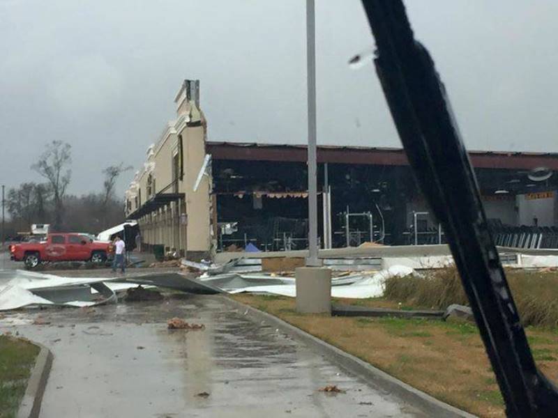
Tornado touched down just before the Gold`s Gym. Damage to the gym was from the metal roof peeling back exposing the exterior wall to the force of the wind pushing it down. The tornado then crossed HIGHWAY 61 and hit several businesses doing roof and siding damage. The garage doors were pushed in a local car mechanic shop and knocked over the Popeye’s Chicken sign. The tornado continued into a residential area damaging roofs, sheds, and patios. All of the damage was rated at EF-0.
Tornado #4 - Livingston Parish/Livingston
Rating: EF-2
Estimated peak wind: 120mph
Path length /statute/: 4.5 miles
Path width/maximum: 0.25 miles
Fatalities: 0
Injuries: 0
Start date: Feb. 23 2016
Start time: 12:42pm CST
Start location: Livingston
Start LAT/LON: 30.4960 / -90.7592
End date: Feb. 23, 2016
End time: 12:51pm CST
End location: Livingston
End LAT/LON: 30.5462 / -90.7156
Survey Summary:
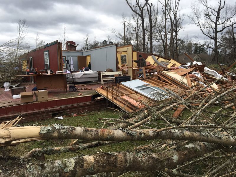
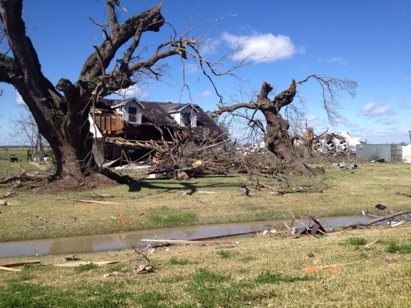
Tornado began in a wooded area between Grantham and McLin Roads southwest of the city of Livingston. The tornado snapped multiple trees and produced minor roof damage on one home with a rating of EF-1 as it crossed McLin Road. The tornado continued northeast and began intensifying and expanding in width. As it reached Circle Drive the tornado began producing EF-2 damage. One home on Circle Drive and another on West Railroad Street had their roofs removed with exterior walls remaining intact. A gooseneck car or tractor hauling trailer was lifted, flipped and set down on top of large storage containers. Many trees in this general area were either snapped or uprooted. The width of the tornado at this point was approximately 325 yards. The tornado continued northeast over a wooded area until reaching North Willow Street. This is the location where it is believed the tornado was at its strongest intensity and widest width. A home’s roof was completely torn off with most exterior walls still standing. The top half of the chimney was completely gone. The only room with a sheetrock ceiling somewhat still intact was the bathroom. All trees had some damage varying from being uprooted or snapped. One uprooted softwood tree was approximately 4 feet in diameter. A rating of EF-2 with 125mph winds was given at this point based on home construction damage and tree damage. The width at this point was 625 yards or over 1/3 of a mile. All houses in the vicinity of the main home damaged had some sort of roof damage but on EF-1 scale. The tornado continued northeast and began weakening. Numerous trees were uprooted as the tornado crossed North Doyle Road near Edgar Mizell Road producing EF-1 damage with speed rating of 95 mph. The tornado dissipated shortly northeast of this point with no other damage found.
Tornado #5 - St. Helena Parish/Montpelier
Rating: EF-0
Path length: 0.75 miles
Fatalities: 0
Injuries: 0
Survey summary:
Damage was mainly to an unsecured trailer and to some weak trees. Additional specifics will be added at a later time.
Tornado #6 - Iberville Parish/White Castle #2
Rating: EF-0
Estimated peak wind: 80mph
Path length: 1 mile
Path width /maximum: 200 yards
Fatalities: 0
Injuries: 0
Start date: Feb. 23, 2016
Start time: 3:10pm CST
Start location: 3.8 S.W. of White Castle
Start LAT/LON: 30.1199 / -91.1733
End date: Feb. 23, 2016
End time: 3:13pm CST
End location: 3.5 S.W. of White Castle
End LAT/LON: 30.1348 / -91.1723
Survey summary:
Damage consisted of garage doors blown in, some light roof damage and sheds demolished.
Tornado #7 - Assumption and St. James Parishes
Rating: EF-3
Estimated peak wind: 140 mph
Path length: 21 miles
Path width /maximum: 350 yards
Fatalities: 2
Injuries: Approximately 75
Start date: Feb. 23 2016
Start time: 3:21pm CST
Start location: 2 S.W. of Paincourtville
Start LAT/LON: 29.9903 / -91.0794
End date: Feb. 23, 2016
End time: 3:42pm CST
End location: 8 N.E. of Convent
End LAT/LON: 30.1250 / -90.7697
Survey Summary:
A strong tornado touched down just southwest of Paincourtville, Assumption Parish and moved northeast for 12 miles and crossed the Mississippi River into St. James Parish. The strong tornado continued northeast for another 8 miles, with the last visible damage on airline Highway about 7 miles north northeast of Convent. In Assumption Parish, significant damage was noted to residential and business structures in the Paincourtville area in the vicinity of the junction of La. HIGHWAY 1/La. 308/La. 70. EF-2 scale damage was noted in this area with considerable damage to a small two story apartment building, hardware store and commercial business. A tractor trailer was also overturned at a commercial business in this area. The tornado tracked northeast along La. 1/La. 308 causing major damage to an area of small frame houses and mobile homes, with most damage in the EF-1 area. Further to northeast, the 2nd floor of well-constructed brick structure was nearly removed. A low end EF-3 scale rating of 140mph was assigned to this damage. The residents of this structure had taken shelter in the lowest floor of an interior area and were not injured. Further northeast, two small frame homes on piers were swept off their foundation and destroyed. None of the occupants were at either of these residences at the time. The tornado continued to travel northeast crossing the Mississippi River with considerable tree damage in the Batture area of the river. Overall, Assumption Parish emergency management reported the following damage: 45 structures destroyed or not salvageable, 22 structures major damage, 22 structures moderate damage.

After crossing the Mississippi River, the damage path was quite wide at this point and moved through the Sugar Hill RV Park where numerous travel trailers were tossed and destroyed. Numerous trees were snapped or uprooted in this area, with a damage width of 350 yards. Two fatalities occurred at the RV Park, 31 were transported to medical facilities, with 7 of those listed in critical conditions on arrival. Another 25 to 50 were injured and treated at the scene or self-transported to medical care. An EF scale rating of an upper end EF-2 was assigned to this area with max wind of 125 mph. The tornado continued to track northeast and crossed La. HIGHWAY 3125 with trees snapped and uprooted in a 200 yard path. A residence suffered minor property damage. The tornado weakened as it crossed U.S. HIGHWAY 61 with tree limbs snapped and a few trees uprooted in a narrower path. No damage to trees was noted along I-10 to the northeast. Radar also indicated that the parent mesocyclone circulation weakened considerably in the vicinity of U.S. 61 or Airline Highway. St. James Parish emergency management preliminarily reported 25 to 50 homes were total losses and a public housing complex had major damage.
Tornado #8 - Northern Pearl River County
Rating: EF-1
Estimated peak wind: 90 mph
Path length: 2.5 miles
Path width /maximum: 75 yards
Fatalities: 0
Injuries: 0
Start date: Feb. 23, 2016
Start time: 3:50pm CST
Start location: 5.6 East of Angie
Start LAT/LON: 30.9659 / -89.7902
End date: Feb. 23, 2016
End time: 3:54pm CST
End location: 6.6 N.E. of Angie
End LAT/LON: 31.0021 / -89.7052
Survey summary:
Tornado was surveyed by the Jackson National Weather Service. Damage consisted of a mobile home shifted off its foundation and trees and large branches snapped. The tornado continued into Lamar County.
Tornado #9 - Central Pearl River County
Rating: EF-1
Path length: 7.7 miles
Fatalities: 0
Injuries: 0
Survey summary:
Damage to trees and structures was consistent with a low end EF-1. Additional specifics will be added at a later time.
Tornado #10 - St. John the Baptist Parish/Akers
Rating: EF-1
Estimated peak wind: 100 mph
Path length: Estimated 3 miles
Path width /maximum: 250 yards
Fatalities: 0
Injuries: 0
Start date: Feb. 23, 2016
Start time: 4:15pm CST
Start location: Akers
Start LAT/LON: 30.2195 / -90.4354
End date: Feb. 23, 2016
End time: 4:17pm CST
End location: Akers
End LAT/LON: 30.2266 / -90.3833
Survey summary:
Tornadic waterspout came ashore snapping Cyprus trees near Akers. The tornado crossed I-55 at mile marker 12 where multiple snapped Cyprus trees were noted.
Tornado #11 - St. John the Baptist Parish/LaPlace
Rating: EF-2
Estimated peak wind: 130mph
Path length: 4.5 miles
Path width /maximum: 250 yards
Fatalities: 0
Injuries: 17
Start date: Feb. 23, 2016
Start time: 4:32pm CST
Start location: LaPlace
Start LAT/LON: 30.0732 / -90.5067
End date: Feb. 23, 2016
End time: 4:44pm CST
End location: LaPlace
End LAT/LON: 30.3831 / -90.1594
Survey summary:
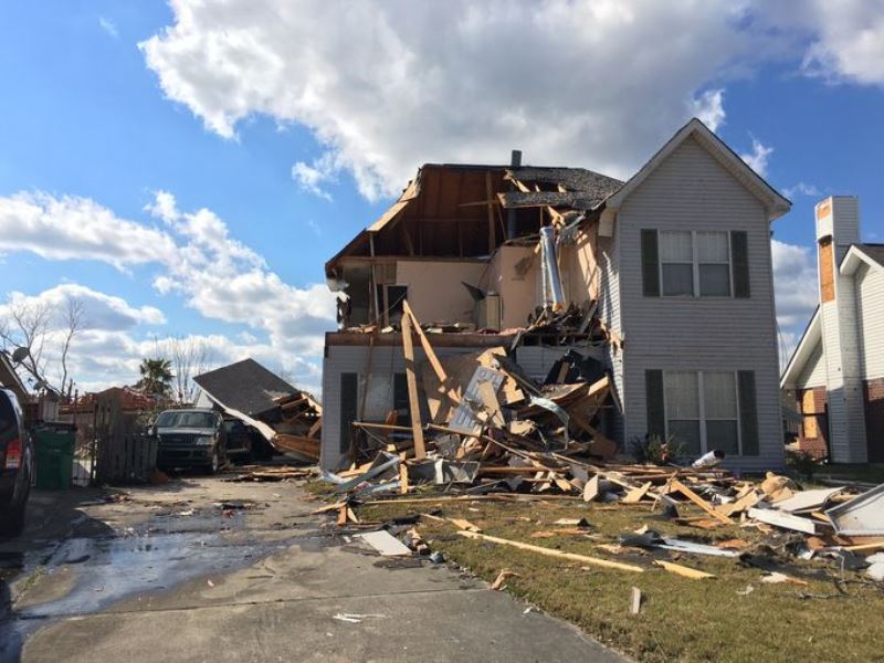
The tornado touched down near the New Wine Fellowship removing much of its roof covering. It snapped power poles as it moved across Airline Highway and then moved into a retail area where it blew out windows and removed roof covering and fascia from several buildings. The tornado was at its widest around this time with a width of 250 yds. Damage in this area was consistent with EF-1 wind speeds. The tornado then continued northeast into the Carrollwood area causing a broad area of EF-0 and EF-1 damage. Large trees were snapped and several homes suffered roof damage mostly consisting of loss of shingles and some decking. The tornado continued northeastward into the Riverland Heights Subdivision. The most substantial damage in this area was along Greenwood Drive where the tornado was moving roughly parallel to the street. Many homes suffered roof damage and a few lost portions of the roof structure. Two homes suffered the collapse of a single exterior wall but it was noted that the damage was likely a result of garage door failures allowing the wind to lift the roof off from inside and then pushing the exposed wall out. Very little damage was noted to the tops of the standing walls despite the entire roof being torn away. The tornado contracted slightly with a width of approximately 200 yards at this point. The tornado continued northeastward and intensified a bit as it reached the Cambridge Area. In this area, a narrow stretch of EF-2 damage was noted near the intersection of Heritage Cove and Virginia Colony Avenue. Here, a few homes and duplexes suffered partial to total loss of roof structure and decking, partial exterior wall failures and blown out windows. This damage occurred with no apparent failures of patios/porches or garages. We believe the damage in this area to be consistent with peak winds around 115 to 120 mph. The tornado continued to strengthen as it moved through a wooded area and emerged into the Palmetto and Indigo Estates Subdivisions. This is where the worst damage along the path occurred. Near the intersection of Nicole and Gail Streets, two single story homes suffered complete roof loss as well as total failure of most exterior walls. A third home lost about half of its second floor. Damage in this area is consistent with a strong EF-2 wind speeds near 130mph. Two other homes on Sawgrass Drive suffered total roof loss and partial failure of exterior walls. The tornado continued northeastward causing damage to a large metal building at which point the tornado began to rapidly weaken. It crossed Interstates 10 and 55 causing damage to trees and the last damage was observed near Frenier Road and U.S. Highway 51 where a light pole was snapped and tree branches were broken.
Tornado #12 - St. Tammany Parish/Madisonville
Rating: EF-0
Estimated peak wind: 65mph
Path length: 0.5 miles
Path width /maximum: 25 yards
Fatalities: 0
Injuries: 0
Start date: Feb. 23, 2016
Start time: 4:41 pm CST
Start location: Madisonville
Start LAT/LON: 30.3779 / -90.1613
End date: Feb. 23, 2016
End time: 4:42pm CST
End location: Madisonville
End LAT/LON: 30.3831 / -90.1594
Survey summary:
A tornadic waterspout moved onshore from Lake Pontchartrain at the end of Highway 1077 producing a short path of damage. An open air coast guard boat shed experienced column and roof failure and a bar had minor fascia damage. No damage to power poles or trees was noted in the area. No damage was noted across the Tchuefncte River. Damage was consistent with a 65 mph EF-0 tornado.
Tornado #13 - St. Tammany Parish/Lacombe
Rating: EF-0
Estimated peak wind: 80mph
Path length: 1.25 miles
Path width /maximum: 75 yards
Fatalities: 0
Injuries: 0
Start date: Feb. 23, 2016
Start time: 5:13 pm CST
Start location: Lacombe
Start LAT/LON: 30.3218 / -90.5067
End date: Feb. 23, 2016
End time: 5:15 pm CST
End location: Lacombe
End LAT/LON: 30.3264 / -89.9451
Survey summary:
Tornado began near a plant nursery at Powell Street and Pichon Street. EF-0 damage was noted in this area mainly in the form of damaged plastic greenhouses and a few uprooted softwood pine trees. The tornado then crossed Highway 190 and proceeded on a northeast track through a wooded area before producing minor damage to two mobile homes on North 25th Street. Busted windows and damaged underskirting was noted in this area. This damage is consistent with an EF-0 tornado. After passing over North 25th Street, the tornado cut northeast through another wooded area producing additional tree damage. The tornado continued northeast and then damaged homes on Gitz Road, Tagalong Road, Heltemes Lane, Cloverland Drive and Fish Hatchery Road. Damage consisted of shingles removed from roofs, siding and fascia damage and uprooted softwood and hardwood trees. All of this damage was consistent with an EF-0 tornado with winds of between 75 and 80 mph.
For the latest forecast from our weather team, CLICK HERE.
You can also keep up with WBRZ Weather on Facebook and Twitter.
More News
