

Latest Weather Blog
Wednesday AM Forecast: Frigid conditions again this morning, gradual warmup before next cold front
Dangerous wind chills and hard freeze conditions remain a large threat to the state this morning. Over the next 48 hours, we will see a gradual warm up of temperatures ahead of another cold front that will send temperatures back down into hard freeze territory this weekend.
Today & Tonight: We remain under a Wind Chill Advisory and Hard Freeze Warning until 10am today. Dangerous wind chills in the teens or below will make for another frigid start. Afternoon temperatures today are expected about 10° warmer than Tuesday, in the mid-upper 40s, and winds will be light. Overall, with plenty of sunshine, Wednesday afternoon will be more bearable than the past 24 hours.
Overnight, as winds shift to more of a southerly flow we will see our low temperature right around midnight with gradual warming during the early morning hours. Temperatures will most likely be in the upper 30s/lower 40s when you head out the door to school or work Thursday morning.
Alerts & Expectations:
Hard Freeze Warning - Coldest temperatures of the week are likely early Wednesday. Until 10am this morning, the state remains under the hard freeze warning as the hard freeze conditions will kill crops, other sensitive vegetation and possibly damage unprotected outdoor plumbing. Wrap pipes with foam, newspaper or cloth and lightly drip a faucet overnight. Sensitive vegetation will likely die if not covered or moved inside.
Wind Chill Advisory - Wind chills in the teens are likely through Wednesday morning. Make sure people and pets have access to warmth. Minimize time outside, be sure to wear many light, loose fitting layers and keep extremities such as toes, fingers and ears covered. The advisory is in effect until 10am Wednesday morning.
With cold temperatures and gusty winds, heat is more quickly transported way from the body, especially where skin is exposed. This can quickly lead to hypothermia. In addition the wind will cause exposed pipes and car radiators to cool more rapidly and reach to the actual air temperature far sooner than expected. Those objects will not cool below the air temperature, however.
Trending News
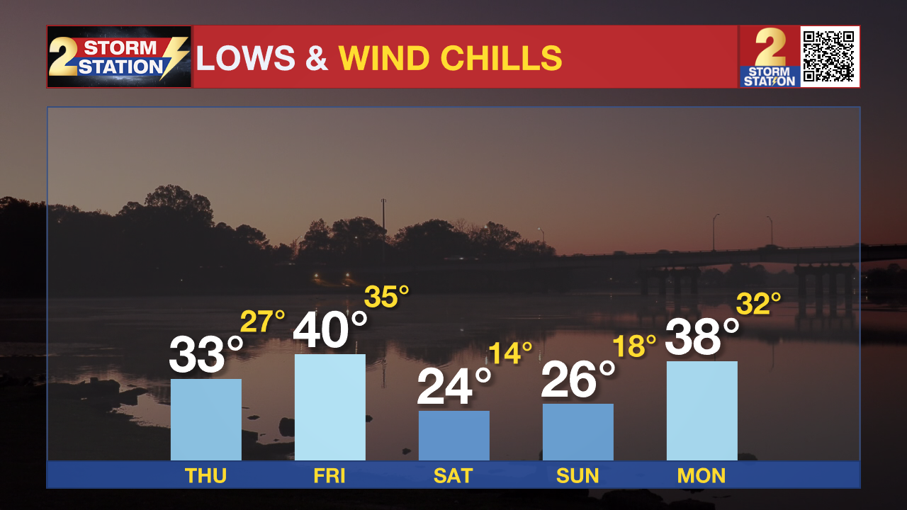
Up Next: Despite mostly cloudy skies, highs will likely reach the 60s on Thursday. Spotty light rain is also not out of the question, but we'll be warm enough to see all precipitation in the liquid form. Behind that system, a cold front arrives overnight Thursday, delivering another push of cold air that will arrive in time for the weekend. Both Saturday and Sunday morning lows dip back into the 20s, allowing for the possibility of another hard freeze so keep your pipes wrapped up! Afternoon highs this weekend will also be chilly with Saturday seeing the 40s and Sunday high temperatures in the 50s.
Get the latest 7-day forecast and real time weather updates HERE.
Watch live news HERE.
The Storm Station is here for you, on every platform. Your weather updates can be found on News 2, wbrz.com, and the WBRZ WX App on your Apple or Android device. Follow WBRZ Weather on Facebook and Twitter for even more weather updates while you are on the go.
More News
