

Latest Weather Blog
Friday PM Forecast: few shots of rain before Christmas cold blast
With below average temperatures, there are a couple of chances for rain through early next week. A big blast of cold air is expected right before Christmas.
Next 24 Hours: Clouds will slowly increase overnight. With that, low temperatures will stay up a few degrees compared to previous nights and stop in the mid 40s. On Saturday, a very weak upper level disturbance will push through the region. Though the atmosphere is going to be rather dry, there could be just enough moisture to squeeze out a couple of light showers on an otherwise cloudy day. The dreary skies will keep high temperatures in the mid 50s.
Up Next: The second half of the weekend will be clear and chilly with Sunday morning lows in the low 30s and afternoon highs in the upper 50s. An area of low pressure will move across the Gulf of Mexico early in the week delivering a period of rain to the central Gulf Coast late Monday through early Tuesday. Temperatures are expected to stay at or below average Monday through Thursday with highs in the 50s and lows in the low to mid 40s. Thursday night, a very strong cold front will punch through the area delivering a big chill for the holiday. Friday through Christmas should have highs in the 40s and lows in the 20s—if not colder. CLICK HERE for your detailed 7-Day Forecast.
We have increasing confidence that the coldest air so far this season will arrive just ahead of #Christmas. ?? ?? #LaWX #MsWX
— Josh Eachus (@DrJoshWX) December 15, 2022
(note that this image is a computer model forecast and the exact numbers will change a bit over the next 10 days) pic.twitter.com/snAMONb7W2
Trending News
The Explanation: A large upper level trough of low pressure extends across the eastern United States. A small disturbance cycling through the base of the larger trough will swing through the region on Saturday. Though largely moisture starved, this system will squeeze out what is available to produce a passing pocket of clouds and even a few light showers. In the wake of that disturbance, a refreshed northwest breeze will send in even colder air. As long as skies clear as expected, thermometers could take a run at freezing on Sunday morning.
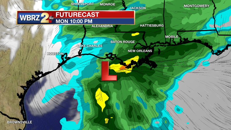
On Monday, another upper level trough of low pressure will drop into the southern U.S. causing a surface low pressure system to form along the coast of Texas. This low will track from west to east across the Gulf of Mexico and a more abundant pocket of moisture will lead to a shield of precipitation moving across the central Gulf Coast States. With the surface low remaining well south of the state, instability will stay offshore and this system will just produce a cool, steady period of rain. About an inch will fall in most areas. Behind this we will see another light reinforcing shot of slightly cooler air but then we wait for the arrival of a blast of cold air and the lowest temperatures so far this season. A strong cold front will blow through on Thursday, without enough moisture for precipitation. However, the following blast of cold air will lead to highs in the upper 30s and low 40s as well as lows in the 20s for Friday, Christmas Eve and Christmas Day.
--Josh
The Storm Station is here for you, on every platform. Your weather updates can be found on News 2, wbrz.com, and the WBRZ WX App on your Apple or Android device. Follow WBRZ Weather on Facebook and Twitter for even more weather updates while you are on the go.
More News
