

Latest Weather Blog
Friday AM Forecast: Storms exiting this morning, Spotty showers possible all weekend
Showers and storms around southern Louisiana early Friday create slick roadways for your morning commute. Later today and into the weekend, spotty showers are possible with more storms expected next week.
Today & Tonight: Widespread rain began around midnight Friday morning, some storms in SE LA even spitting out hailstones. Coverage and intensity of the rain gradually decreases throughout the morning commute hours and showers will become light and spotty by Friday afternoon. Temperatures beginning in the upper 40s will rise into the low to mid 60s this afternoon making for a chilly end to the workweek. This afternoon, while much drier than the start to the day, will remain mainly cloudy.
Overnight, with some breaks in the clouds, fog formation is possible and visibilities could be limited early Saturday morning. Temperatures overnight will dip into the 50s and spotty showers and storms cannot be ruled out.
Up Next: This weekend could see spotty showers and storms both days however there will be plenty of dry time! Temperatures begin each morning in the mid-50s to low 60s, with light winds that could allow for fog to develop. By the afternoons we will be much warmer than previous days, with afternoon highs in the mid-70's to low-80's. The weekend will remain mostly cloudy but a few peaks of sunshine are possible, especially on Saturday! If you have any outdoor activities planned over the weekend, keep rain gear handy incase you run into one of the nuisance storms.
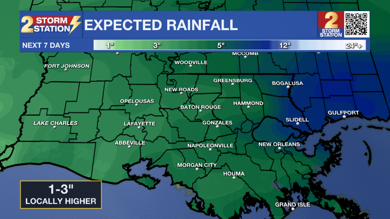
We kick off the first full week of March with an unsettled weather pattern. Each day will see above average temperatures but also an opportunity for scattered showers and storms. The unsettled pattern is caused by another cold front that will approach the state from the NW at the start of the workweek. Timing with this system remains tricky to pinpoint but will likely move through late Monday through early Tuesday. This cold front will not have a huge impact on temperatures but will bring more rounds of storms and around 1-3 more inches of rainfall. Make sure to stay up to date with the latest details over the weekend by watching WBRZ each morning and evening or downloading the free Storm Station weather app HERE.
Trending News
Get the latest 7-day forecast and real time weather updates HERE.
Watch live news HERE.
– Emma Kate Cowan
The Storm Station is here for you, on every platform. Your weather updates can be found on News 2, wbrz.com, and the WBRZ WX App on your Apple or Android device. Follow WBRZ Weather on Facebook and Twitter for even more weather updates while you are on the go.
More News
