

Latest Weather Blog
Friday AM Forecast: More cold warnings issued for the weekend
A cold front overnight ushers in another punch of frigid air for the weekend. More cold warnings are being issued as cold air moves back into the state throughout the day today.
Today & Tonight: As a cold front exits the state this morning, skies continue to clear and temperatures around southern Louisiana range from the 40s to low 50s. By sunrise, mostly sunny skies will dominate and winds will begin to ramp up. Overall, Friday will be breezy and cool with afternoon temperatures in the low 50s and winds out of the north between 10-20 mph with gusts up to 30mph. The northerly winds help to quickly usher in more bitterly cold air. Once the sun sets around 5:30 this evening, temperatures will quickly fall.
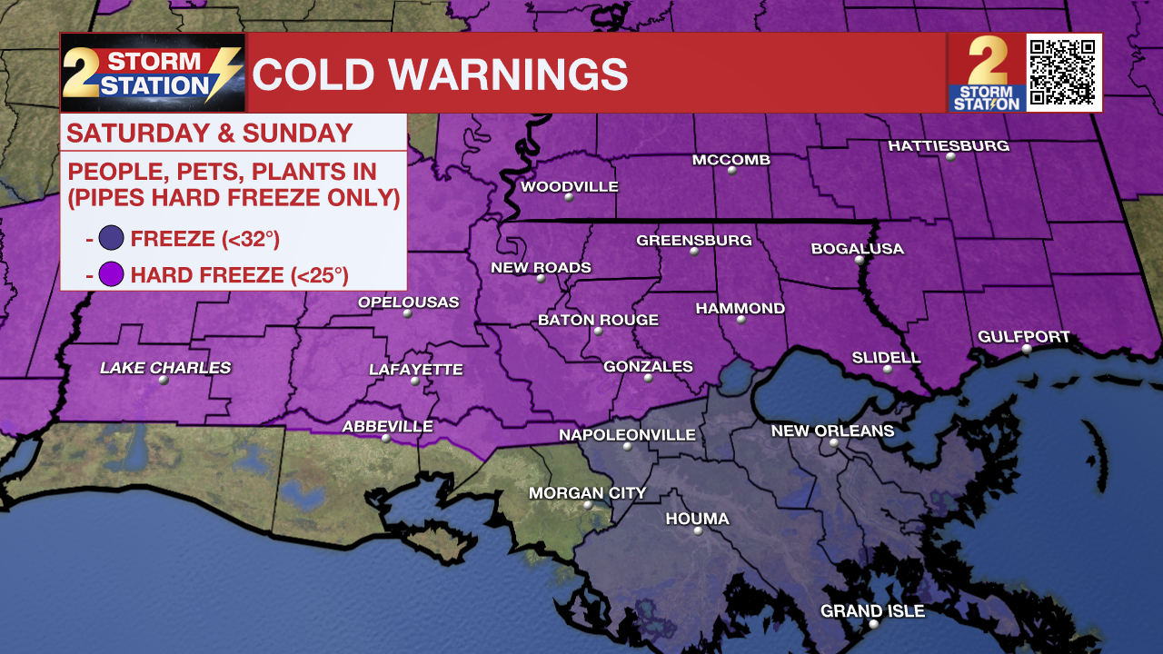
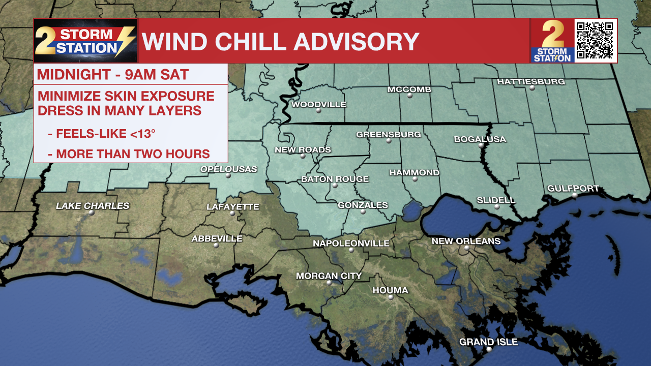
Overnight, below freezing temperatures are anticipated for many hours and low temperatures in the 20°s across the state puts the majority of southeast Louisiana back in a Hard Freeze Warning until 9am Saturday morning. Wind chills in the teens will make things feel even colder so bundle up and keep extremities covered if you have outside activities planned tomorrow morning.
THIS WEEKEND:
You will once again need your cold weather gear this weekend. Morning lows will drop into the 20s across the state with wind chills in the teens or below. Conditions stay chilly each afternoon with Saturday's high temperature expected in the mid-40s and Sunday seeing a high temperature near 50° despite plenty of sunshine.
Trending News
Alerts & Expectations:
Hard Freeze Warning: Temperatures are expected to dip into hard freeze territory and remain there for multiple hours both Saturday and Sunday mornings. Wrap pipes with foam, newspaper or cloth and lightly drip a faucet overnight. Sensitive vegetation will likely die if not covered or moved inside.
Wind Chill Advisory - Wind chills in the teens are likely Saturday morning. Make sure people and pets have access to warmth. Minimize time outside, be sure to wear many light, loose fitting layers and keep extremities such as toes, fingers and ears covered. The advisory is in effect until 10am Wednesday morning.
With cold temperatures and gusty winds, heat is more quickly transported way from the body, especially where skin is exposed. This can quickly lead to hypothermia. In addition the wind will cause exposed pipes and car radiators to cool more rapidly and reach to the actual air temperature far sooner than expected. Those objects will not cool below the air temperature, however.
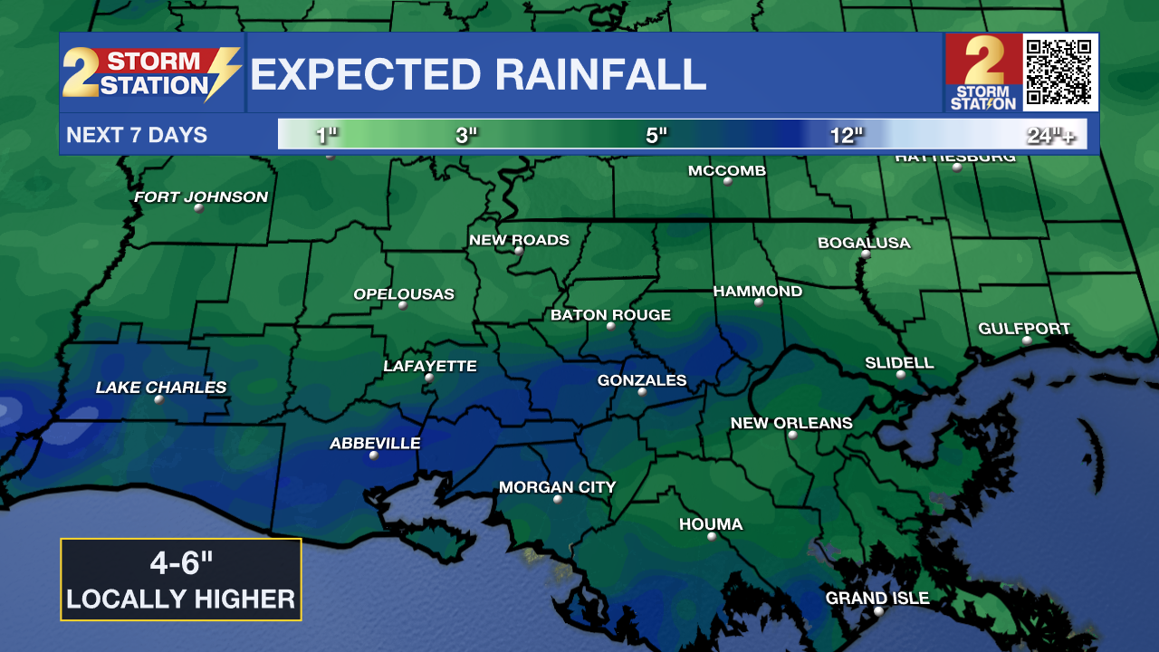
Up Next: The new workweek brings new weather conditions. Monday morning's low will be about 10-15° warmer than the previous day, taking us out of hard freeze territory and hinting at the warming trend that will take place next week. An increase in cloud cover on Monday will occur ahead of the first round of rain expected of the week that will arrive Monday evening/night.
Throughout the entire workweek you will need to keep your raingear handy! Between Tuesday - Thursday, 4-6" of rainfall with locally higher amounts is expected. Beginning Tuesday, scattered rainfall activity is likely and the possibility of thunderstorm activity begins by the middle of the week. Along with the soggy conditions, temperatures will also be well above average, with afternoon temperatures around 70°.
Get the latest 7-day forecast and real time weather updates HERE.
Watch live news HERE.
– Emma Kate Cowan
The Storm Station is here for you, on every platform. Your weather updates can be found on News 2, wbrz.com, and the WBRZ WX App on your Apple or Android device. Follow WBRZ Weather on Facebook and Twitter for even more weather updates while you are on the go.
More News
