

Latest Weather Blog
Friday AM Forecast: Showers and storms this weekend, Much cooler next week
Grab your raingear! A cold front moving towards Louisiana today brings multiple opportunities of showers and storms this weekend. Behind the system, much cooler and drier air moves in.
Today & Tonight: Friday starts off warm, with temperatures around the state in the mid-70's. The morning commute will remain mostly dry with overcast skies. Later this morning, showers and storms will gradually move into the Capital Region from the north. During the day on Friday, scattered shower activity is expected so check your radar before heading out the door. We expect 80% coverage of the showers and storms today, so while not everyone will see rain, most are likely to at some point during the day. The late morning to late afternoon period looks most active. Heavy rain and gusty winds are possible within stronger storms.
Overnight tonight, temperatures will slightly cool off, into the upper-60's, with cloudy skies. Rain coverage quickly dwindles and Saturday morning continues to trend dry!
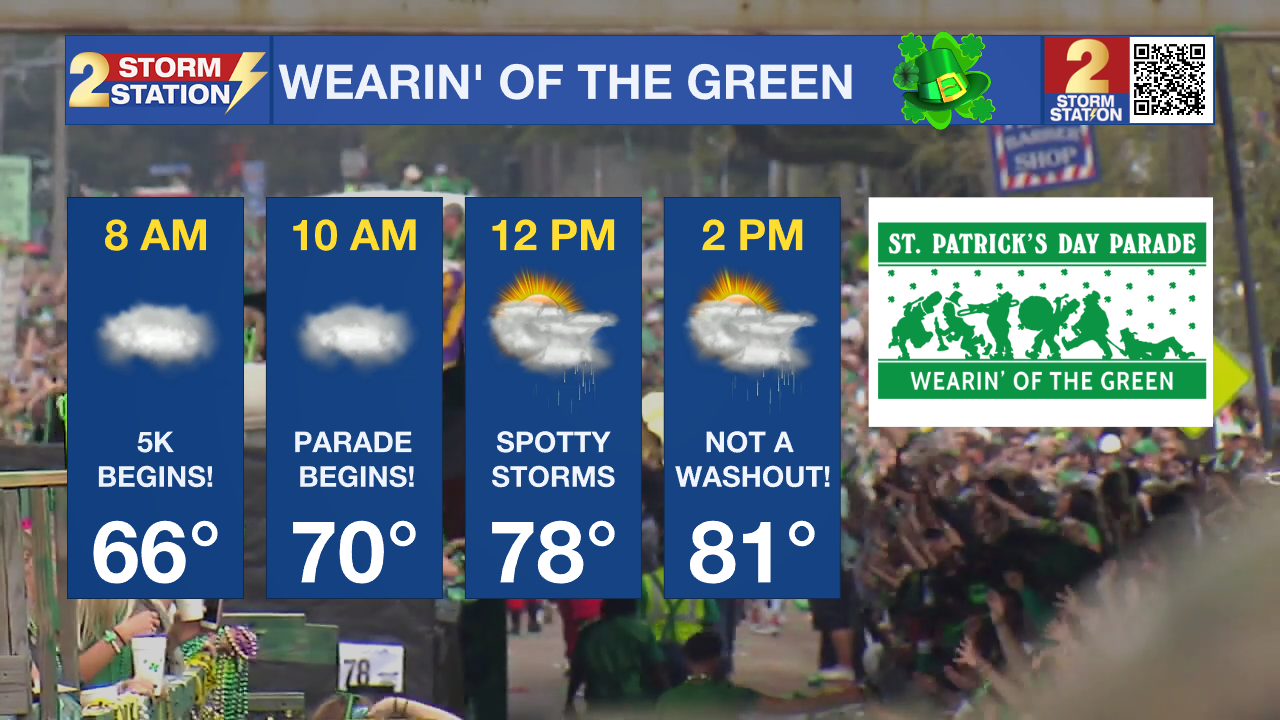
Up Next: As the cold front that brings storms to our area on Friday stalls out over the region on Saturday, the chance for isolated showers and storms does remain, but overall a lull in activity is expected during the day. Saturday morning will see the most dry time of the day, great news for those heading out to the Wearin' of the Green Parade, but it would be advised to bring your raingear just in case a nuisance shower passes by. By late Saturday, there is a slightly better chance for isolated storm development around southern Louisiana. Temperatures early Saturday will be in the upper 60s and warm into the 80s by the afternoon. Mainly cloudy skies will be around all day, but if we are lucky, some sunshine with peak through the clouds!
Trending News
Given the parade and many other outdoor events slated for the weekend, it will be important to keep tabs on the Storm Station forecast, especially regarding any possibility of lightning. Have an indoor contingency nearby in the event of a thunderstorm.
Sunday is trending to be the wettest day of the weekend. The cold front will slowly make it's way out of the state during the day and as it does, numerous showers and storms are expected. Showers will begin Sunday morning and stick around for the majority of the day. A few inches of rainfall will fall between Friday and Sunday and a few strong to severe storms cannot be ruled out.
The passage of the cold front brings cooler and drier air to the state. Temperatures for the first half of the week will be below average, with afternoons in the 60s and morning lows in the 40s. Plenty of sunshine and dry conditions are expected until our next rainmaker arrives late next week.
Get the latest 7-day forecast and real time weather updates HERE.
Watch live news HERE.
– Emma Kate Cowan
The Storm Station is here for you, on every platform. Your weather updates can be found on News 2, wbrz.com, and the WBRZ WX App on your Apple or Android device. Follow WBRZ Weather on Facebook and Twitter for even more weather updates while you are on the go.
More News
