

Latest Weather Blog
Quieting down for now, more storms possible in the days to come
Thursday 9am Update: Strong storms have quickly rolled through the capital region. The leading edge of these storms is now pushing out of the Storm Station coverage area and into the far southeastern reaches of Louisiana. Light to moderate rain continues behind these storms. This rain will likely taper off in the next several hours, setting us up for a drier afternoon.
9am Radar Update - The main line of storms has quickly moved through the capital region. Light to moderate rain remains behind these storms. Once the lighter rain passes, we'll be much quieter for the afternoon. #LAwx pic.twitter.com/QvfXz26X1k
— WBRZ News (@WBRZ) January 25, 2024
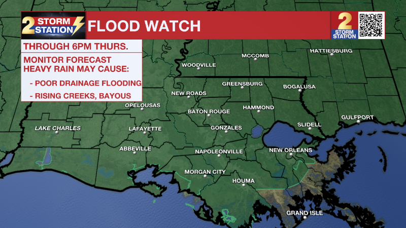
A ***FLOOD WATCH*** will remain in effect through 6pm Thursday. This includes East Baton Rouge, East Feliciana, Iberville, Livingston, Tangipahoa, Pointe Coupee, St. Helena, West Baton Rouge, West Feliciana, Ascension, St. James, and Assumption in Louisiana and Amite and Wilkinson in Mississippi. Excessive runoff from heavy rain may result in flooding of rivers, creeks, streams, and other low-lying and flood-prone locations. Monitor forecasts and be alert for possible Flood Warnings. Those living in areas prone to flooding should be prepared to take action should flooding develop.
Trending News
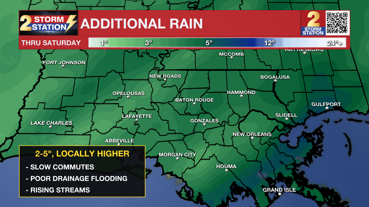
Rainfall: An additional 2 to 4 inches is expected across the Storm Station Viewing Area with the higher totals generally found north and west of Baton Rouge and lower totals near the coast.
Timing: rain and thunderstorms will be more scattered in nature overnight. Another widespread round is expected on Thursday, primarily during the morning hours. A third and final round will come late Friday or early Saturday.
Flooding: the heaviest and steadiest round of rain occurred on Wednesday. Additional rounds will more easily cause problems, especially in those areas that have already flooded. Spots that drain poorly, low-lying streets and smaller creeks that respond quickly to runoff will be most susceptible.
Rivers: runoff will cause rises on local streams with the smaller, rapidly responding rivers most affected. The Tangipahoa River at Robert is projected to crest in moderate flood stage on Friday. So far, all others within the viewing area are expected to stay within their banks.
Safety: Plan to take extra time in case of delays and if you come across a flooded street—find an alternate route. Sometimes it can be difficult to determine how deep the water is and you risk stalling and becoming stranded. Have a way to received alerts, such as the Storm Station App, through Thursday. Review additional flood safety, here.
Today: While radar activity is relatively quiet early Thursday, dense fog in parishes south and east of the Baton Rouge area is causing limited visibility for some. Combining the fog with slick roads and leftover puddles from rain overnight, early morning commutes could get very messy. By mid-morning, a line of heavy showers and storms will move across southeast Louisiana. Unlike yesterday, this system is fast moving but because of already saturated soils, even a small amount of rainfall could cause more flash flooding. Along with the flood risk, gusty winds within the storms could knock down trees and powerlines.
Behind the line of storms, we should catch a break from rain for the rest of the day. Skies will remain cloudy and temperatures mild, in the 60s, with muggy conditions as well. Don't pack up the raingear yet, more rain is set to arrive on Friday!
Tonight: Shower and storm activity should be very limited overnight and temperatures will be in the lower 60s for most. Regardless, slick road conditions and more fog could yet again impact the Friday morning commute. Spotty shower activity will begin early Friday morning while more scattered storm activity around later in the day.
Up Next: Very little change to temperatures will come over the next few days. Highs and lows will remain in the 70s and 60s respectively. Friday afternoon, the last disturbance of the week will roll through, with isolated showers and storms possible that evening through Saturday morning. Once this system clears the Capital Region, much drier weather is expected. A return to average temperatures is in store for the end of the weekend and through at least the middle of next week.
Get the latest 7-day forecast and real time weather updates HERE.
Watch live news HERE.
The Storm Station is here for you, on every platform. Your weather updates can be found on News 2, wbrz.com, and the WBRZ WX App on your Apple or Android device. Follow WBRZ Weather on Facebook and Twitter for even more weather updates while you are on the go.
More News
