

Latest Weather Blog
Beat the heat, stay safe outdoors this weekend
Heat will remain the main weather story for the foreseeable future. The best chance for isolated showers and thunderstorms will come on Sunday and Monday.
A *HEAT ADVISORY* will be in effect on Saturday from 10am - 8pm for all of southeast Louisiana and southwest Mississippi. Heat index values up to 112 may cause heat illnesses to occur.
Drink plenty of fluids, stay in an air-conditioned room, stay out of the sun, and check up on relatives and neighbors. Young children and pets should never be left unattended in vehicles under any circumstances. Take extra precautions if you work or spend time outside. When possible reschedule strenuous activities to early morning or evening. Know the signs and symptoms of heat exhaustion and heat stroke. Wear lightweight and loose fitting clothing when possible. To reduce risk during outdoor work, the Occupational Safety and Health Administration recommends scheduling frequent rest breaks in shaded or air conditioned environments. Anyone overcome by heat should be moved to a cool and shaded location. Heat stroke is an emergency!
Tonight & Tomorrow: Not much up top overnight and low temperatures will fail to leave the 80s, again. The weekend will begin with mostly sunny skies. Saturday, high temperatures will soar in the upper 90s and combine with high humidity to produce feels-like temperatures between 107 – 112 degrees during the middle of the day. Though the chance is not zero, most of the area will miss out on cooling rain showers.
Up Next: Sunday, the atmosphere may have just enough instability for scattered showers and thunderstorms to develop by late afternoon. However, activity will likely develop too late to make a major dent in the heat. While all outdoor activities should be giving safety consideration to the temperatures, any lightning around the area could be extra incentive for a break in the air conditioning. Into next week, an upper level ridge of high pressure will expand over the Gulf Coast, keeping the long term trend of hot temperatures and minimal precipitation. Through the week, highs will be in the upper 90s, with one or two spots possibly reaching the century mark, and lows will struggle to leave the 80s. Plenty of humidity will stick around and afternoon feels-like temperatures over 107 degrees will likely warrant continuous heat alerts from the National Weather Service.
Trending News
Get the latest 7-day forecast and real time weather updates HERE.
Watch live news HERE.
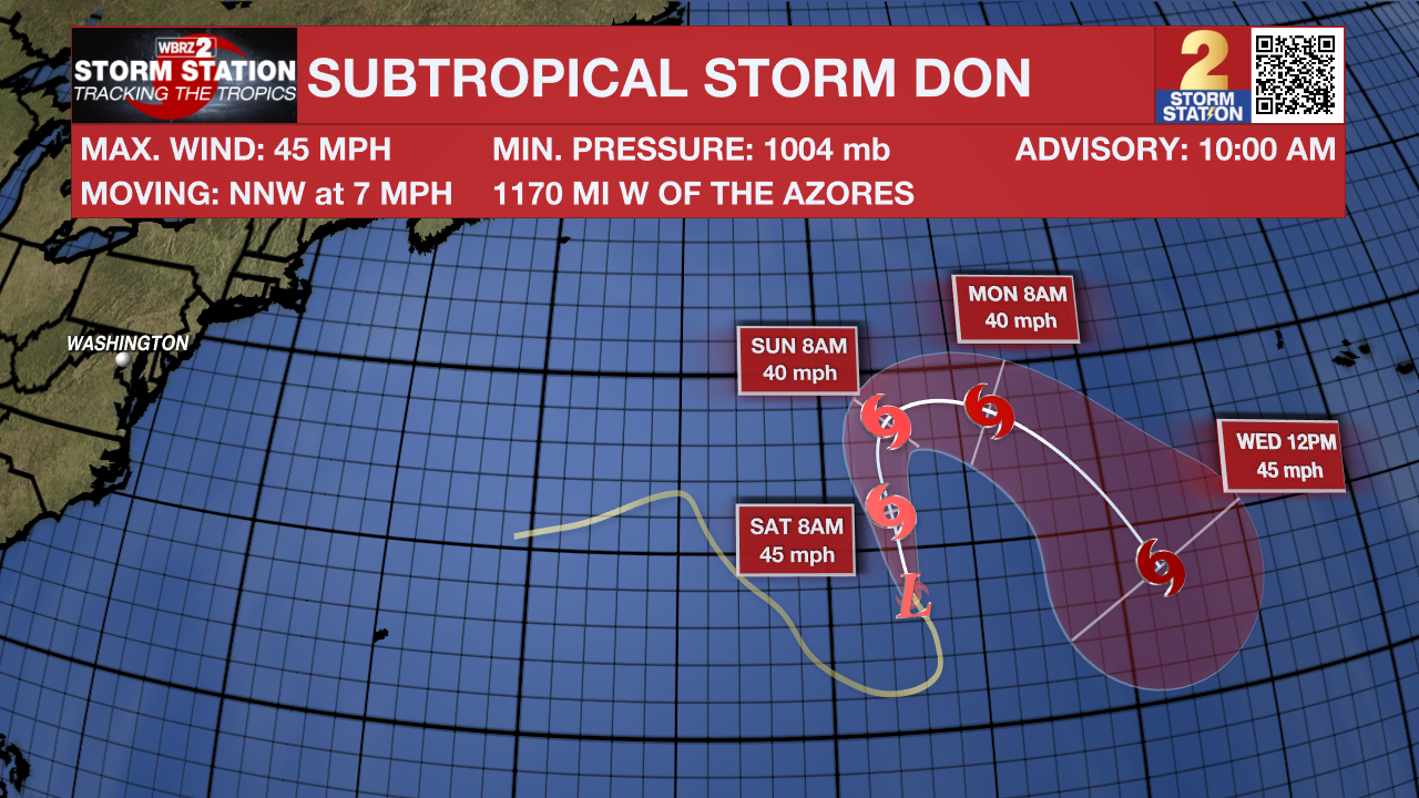
The Tropics: Subtropical Storm Don formed on Friday morning over the central Atlantic Ocean. As of Friday afternoon, Don was drifting northwest at 7mph with maximum sustained winds of 45mph. The storm will start turning north and eventually east later this weekend into next week, gradually weakening while remaining over open water.
--Josh
The Storm Station is here for you, on every platform. Your weather updates can be found on News 2, wbrz.com, and the WBRZ WX App on your Apple or Android device. Follow WBRZ Weather on Facebook and Twitter for even more weather updates while you are on the go.
More News
