

Latest Weather Blog
After historic hail thumps area, heat and storms set to relent
After a historic hail event across the Capital Area on Tuesday evening, a slow transition back to more typical summertime weather is anticipated. Temperatures will creep back toward advisory levels by the end of the Storm Station 7-Day Forecast.
?? Make no mistake, the #hail across Metro #BatonRouge Tuesday evening was a historic event.
— Josh Eachus (@DrJoshWX) June 21, 2023
??Several reports of hail larger than 2.25" and possibly up to 3.00" in diameter
??Since 1950, there have only been 11 reports of hail larger than 2.00" in diameter for this area pic.twitter.com/3BeVSftKOF
Tonight & Tomorrow: Scattered showers and thunderstorms are expected taper overnight. There is still a possibility for frequent lightning, hail, gusty wind and downpours but the threat for those hazards to reach severe status will diminish. Beyond storms, lows will dip a little more than previous nights, into the mid 70s. Of course heat and humidity will remain a part of our forecast Wednesday (and for the rest of summer). However, levels should be more typical for the time of year and the advisories and warnings will be lifted. Highs will reach into the low 90s beneath partly sunny skies. A stray afternoon shower or thunderstorm is possible
Up Next: A somewhat more typical summertime pattern is expected to evolve over the remainder of the workweek. It will still be plenty hot, with highs in the mid 90s and lows in the mid 70s. Humidity will be just a touch lower and maybe just enough so to notice. As a result, feels-like temperatures should stay below the advisory criteria of 107 degrees. Afternoons will still feature a few of those pop up showers and thunderstorms to cool off a few spots. There are some signs that the heat could gradually build again over the upcoming weekend.
Trending News
Get the latest 7-day forecast and real time weather updates HERE.
Watch live news HERE.
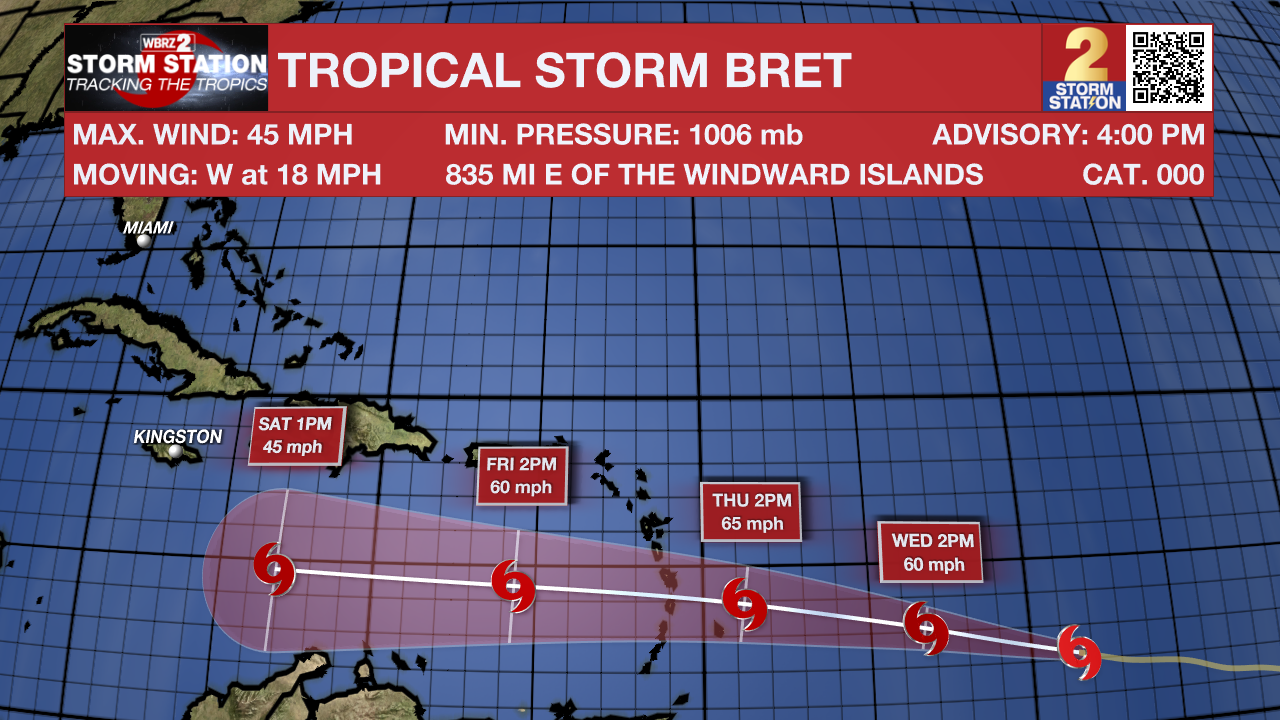
The Tropics: Tropical Storm Bret has strengthened over the central Atlantic Ocean with maximum sustained winds up to 45mph and some additional strengthening expected. Still over 1,000 miles east of the Windward Islands, Bret will continue west at about 18mph before moving over the Lesser Antilles Thursday night. The system is expected to degenerate into an open tropical wave over the weekend in the Caribbean Sea due to harsh wind shear.
In the eastern Atlantic, showers and thunderstorms have diminished during the past several hours in association with a tropical wave located several hundred miles southwest of the Cabo Verde Islands. However, environmental conditions appear conducive for further development of this system, and there is an eighty percent chance that a tropical depression will form during the next couple of days while the system moves westward at 10 to 15mph across the eastern and central tropical Atlantic.
--Josh
The Storm Station is here for you, on every platform. Your weather updates can be found on News 2, wbrz.com, and the WBRZ WX App on your Apple or Android device. Follow WBRZ Weather on Facebook and Twitter for even more weather updates while you are on the go.
More News
