

Latest Weather Blog
Warm with increased humidity
Rain shower development will remain limited, but not impossible, through the holiday weekend.
THE FORECAST:
Today and Tonight: A slightly better chance at pop-up showers will come this afternoon. Still, most locations are expected to stay dry. Highs will again peak in the upper 80s. Humidity will be noticed as well. Overnight lows will be around 70 degrees.
Up Next: The same forecast will go up on the board Thursday and likely Friday. Measurable rain should not be found in more than 20% of the 13 Parish, 3 County forecast area through the week. By Saturday, we’ll bring in a little better opportunity at scattered storms but even this looks unimpressive right now. Overall, Memorial Day Weekend can be summed up as warm, sticky, partly sunny and mostly dry.
THE SCIENCE:
Forecast Discussion: The ridge that lidded the atmosphere on Monday and Tuesday will begin to compress southward into the Gulf of Mexico today. At the same time a few ripples of energy in the 500mb flow will trek across the Gulf Coast. While moisture is limited, the weaker ridge and areas of positive vorticity advection will offer slightly a slightly better opportunity for a few showers or thunderstorms to pop up over the next two afternoons—though geographical rain coverage shouldn’t exceed 20% of the forecast area either day. By Friday and Saturday, a shortwave trough will be moving out of the Midwest and getting absorbed by the mean flow. However, a trough axis lining up Louisiana may be just enough to enhance afternoon shower and thunderstorm development—albeit with coverage remaining low. On Sunday and Monday, a subtle northern push from the ridge and quieter upper levels will again make shower and storm development difficult. Temperature won’t budge much through the stretch with highs in the upper 80s and lows near 70 degrees. Humidity will slowly build through the weekend.
Trending News
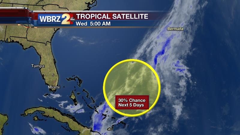
The Tropics: While the local area will be under the influence of a shifting ridge, a deep trough in the Eastern United States could spur some tropical development off of the Southeastern U.S. Coast. Forecast models suggest that the presence of an upper level low may translate into a surface low which could then take on some tropical or sub-tropical characteristics. In fact, the National Hurricane Center has highlighted a region northeast of the Bahamas as having a 30% chance of development over the next five days. What does this mean for the local area? Nothing. What does this mean for the Eastern U.S.? Perhaps some wet weather and increased surf over the Memorial Day Weekend. What does this mean for the tropical season? Very little. As we have noted previously, pre-season storms have not served as a pre-cursor to a more active season. Over a 50 year period to 2015, 13 hurricane seasons brought a total of 16 early-season depressions, storms and hurricanes. Looking at the simple numbers alone, there are no trends. April or May storms are not necessarily a pre-cursor to an active season. Actually, 6 of the 13 years finished with fewer named storms than the averages-12 named storms, 6 hurricanes and 2 major hurricanes.
--JoshFor updates, stay connected with Meteorologist Josh Eachus:
More News
