

Latest Weather Blog
UPDATE: severe weather threat pushed into Saturday
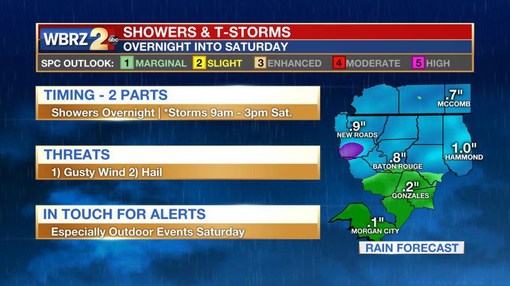
The National Weather Service Storm Prediction Center (SPC) continues a “slight risk” for severe weather on Saturday. This means scattered severe storms are possible within the forecast area. An isolated intense thunderstorm is possible. On a scale of 1 (lowest) to 5 (highest) severe weather threat, this event is a 2. Another way of describing the threat is that there is a 15 percent chance of experiencing severe weather within 25 miles of a given point in the risk area.
UPDATE! Adjusting storm timing and possibility of severe weather deeper into Saturday | #BatonRouge #LaWX #MsWX pic.twitter.com/6xhFpyERch
— Josh Eachus (@JoshEachus) March 24, 2017
Possible Threats:
1) Gusty Wind – in storms that turn severe, wind gusts could exceed 58mph.
2) Hail—in the most intense storms, some marginally severe hail (1” in diameter) could occur.
Trending News
Precipitation: Generally, less than a half inch of rain is expected, though a locally higher amount may be found within the 13 Parish, 3 County Forecast Area—especially where the heaviest storms occur.
Estimated Timeline: Scattered showers and thunderstorms are expected to develop overnight. Strength should be limited then and through dawn. A slowing and weakening cold front will then continue northeastward through the region. Due to some daytime heating, more instability will be available at this time and therefore this second push will offer a better chance for stronger storms to develop from late morning into the early afternoon. Expect skies to clear by the evening.
Impacts: Outdoor events taking place through Saturday Afternoon will want to monitor the radar. Even without severe weather, rain and thunderstorms (lightning) would force activity inside. Have access to weather alerts in case additional action is necessary.
Actions: Get watches and warnings with a NOAA Weather Radio or from the WBRZ Weather Team on Facebook and Twitter. Additionally, the newly updated and *free* WBRZ WX App. sends push notifications to mobile devices if a watch or warning is issued for your location. Remember, a watch means “conditions are favorable, and a particular threat could develop” and a warning means that “threat is happening and you should take action immediately.” Remember, in the event of a severe thunderstorm warning, get inside of a sturdy, enclosed building and move away from windows.
The second half of the weekend will be much quieter with some sun and continued warmth expected on Sunday. Don't let your guard down though. An active pattern is setting up with at least two more round sof severe weather possible next week!
More News
