

Latest Weather Blog
Unsettled with areas of heavy rain this weekend
A wetter pattern with more widespread rain and thunderstorms is expected through the weekend. Any storm downpours could create street and poor drainage flooding.
THE FORECAST:
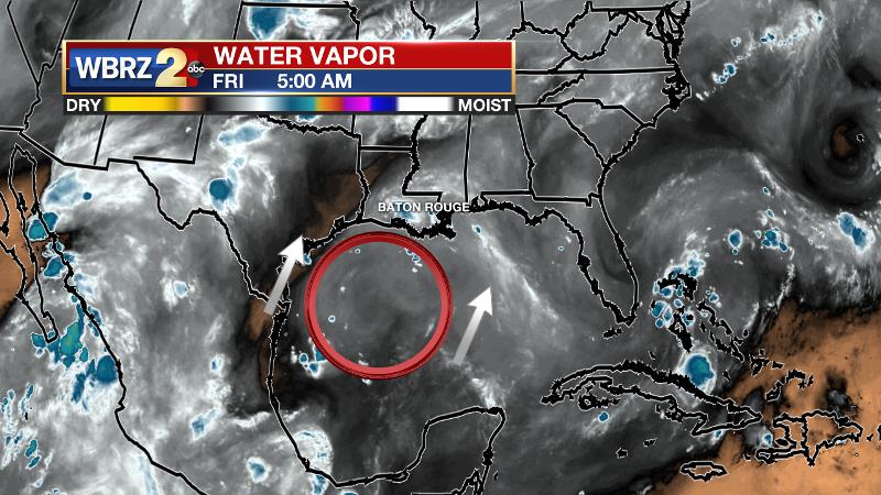
Today and Tonight: A pocket of moisture from the Gulf of Mexico will allow the crop of showers and thunderstorms to develop earlier and be more widespread on Friday. High resolution forecast model guidance suggests the heavier pockets will be both west and east of Baton and mainly over with before the late afternoon commute. Still, any thunderstorms will be capable of downpours. Due to rain and clouds, high temperatures will stop in the upper 80s. Overnight will be mostly cloudy with low temperatures in the low to mid 70s.
Up Next: The same, generally active, weather pattern will continue into early next week. About 2 to 5 inches of rain is anticipated with any nuisance flooding issues occurring in locations that receive the higher amounts. Though many areas will experience rain Saturday through Monday, daylong washouts are not anticipated. If you have outdoor plans, do not expect cancellations but have an accessible shelter if lightning is in the area. Also, do not risk stalling your vehicle and getting stranded by driving across a flooded road. Afternoon thermometers may be a few degrees below average for the time of year because of the active weather but overnight lows will be near average.
Trending News
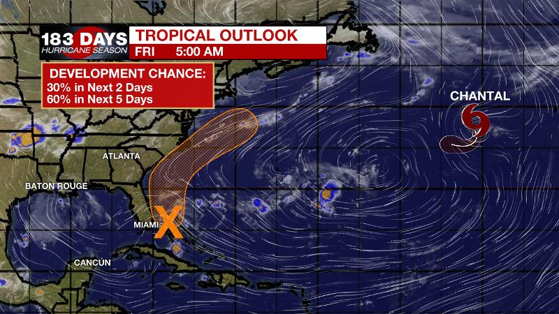
The Tropics: Tropical Depression Chantal is slowing and weakening in the North Atlantic. As of 5am Friday, the storm had 35mph maximum winds and a minimum central pressure of 1010mb. Chantal will degenerate into an open low over the next two days. A trough of low pressure located over the Bahamas is producing disorganized showers and thunderstorms. After moving into Florida, some slow organization may occur over the weekend as the system emerges in the western Atlantic off the Southeast U.S. Coast. The National Hurricane Center gives a medium, 60 percent chance of development. This system does not pose a threat to the local area.
THE EXPLANATION:
A shortwave trough will move across the southern third of the U.S. as a plume of moisture moves into the region. The origin of this moisture will be tropical so drenching thunderstorms could lead to some nuisance flooding issues over the weekend.
In general, 2 to 5 inches of rain is expected. The Weather Prediction maintains a 1/4 “marginal risk” for excessive rain, mainly for coastal parishes, Friday and Saturday. The risk spreads farther north on Sunday. Locations caught under storm downpours receiving the higher end of those totals could experience some brief street and poor drainage flooding. Some of the stronger thunderstorms will also be capable of brief, gusty wind and frequent lightning. This pattern will continue until Monday. Then, more seasonal moisture levels will be restored and so too will be seasonal rain coverage. In the too early to call with confidence department, there are some signs that a weak front could provide slightly lower humidity by the end of next week. At this time, the ECMWF is stronger pushing the cold front through the forecast area on Thursday and Thursday night while the GFS keeps the boundary mostly north of the forecast area.
--Josh
The WBRZ Weather Team is here for you, on every platform. Your weather updates can be found on News 2, wbrz.com, and the WBRZ WX App. on Apple and Android devices. Follow WBRZ Weather on Facebook and Twitter for even more weather updates while you are on the go.
More News
