

Latest Weather Blog
Tricky Father's Day forecast
On Thursday, scattered showers and thunderstorms developed on time bringing rain to approximately 50 percent of the 13 Parish, 3 County area as was forecast. Slightly more activity may squeeze out on Friday as higher moisture content works with a weak upper level impulse drifting west out of Alabama.
THE FORECAST:
Today and Tonight: With fast warming into the low 90s, scattered showers and thunderstorms will develop around noon on Friday, maxing out in coverage during the afternoon hours. As is always the case, warm season storms lack direction but have plenty of energy to produce frequent lightning and downpours leading to nuisance flooding. Look for about 60 percent of our 13 Parish, 3 County forecast area to receive rain today. Activity will diminish shortly after dusk with overnight lows in the low 70s.
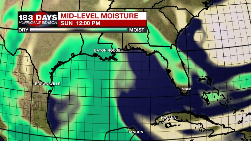
Up Next: Of the two weekend days, Saturday is looking a bit better. At least for the morning hours, there should not be a whole lot of rainfall. By afternoon, scattered showers and thunderstorms could interrupt some outdoor plans. Keep this in mind and remember that while we all “run from the rain” to avoid getting wet, lightning is the actual danger. If you can hear thunder, you are close enough to be struck so geaux inside until the storm passes. Father’s Day will bring the possibility of more widespread rain, as a surge of tropical moisture reaches the local area, although an all-day washout is not likely. A general 1 inch of rain is expected with isolated higher amounts where persistent downpours occur. Given the sharp gradient in moisture from east to west, there is some bust potential with this forecast. Look for updates and changes as we move into the weekend. This tropical moisture will budge westward after about a day or so returning the area to more normal weather.
Trending News
The Tropics: Am unorganized area of lower pressure in the southwestern Gulf of Mexico will not develop as it approaches the western Gulf Coast. However, associated moisture is likely to reach the western half of the Gulf Coast by the upcoming weekend, increasing rain chances and rain totals. However, there will be a sharp west to east cutoff in the moisture field across the central Gulf Coast leading to a tricky rain forecast.
THE EXPLANATION:
Good surface heating and elevated atmospheric moisture will allow for early initiation of storms and slightly higher than normal coverage. Activity will fire along subtle, very hard to detect outflow boundaries. Thunderstorms will be capable of the usual downpours and frequent lightning. Due to the scattered nature of the precipitation, some locales will remain dry while others collect a quick inch or more of rain. By Sunday, forecast focus will turn to a plume of tropical moisture moving northwestward through the western Gulf of Mexico. Forecast models are showing moisture stretching from Mexico all the way to southeast Louisiana with the local area on the fringe of this moisture. Should the deeper moisture nudge west, the forecast could “bust” with lower rain chances and lower rain totals than currently expected. A general 1-2 inches for southeast Louisiana and southwest Mississippi is likely. Into next week, the area will be caught between a trough to the southwest and a ridge to the northeast. Indications are that the ridge will begin to win out, leading to more subsidence and possible decreasing rain chances by the middle of next week.
--Dr. Josh
The WBRZ Weather Team is here for you, on every platform. Your weather updates can be found on News 2, wbrz.com, and the WBRZ WX App. on Apple and Android devices. Follow WBRZ Weather on Facebook and Twitter for even more weather updates while you are on the go.
More News
