

Latest Weather Blog
SCIENCE: Features besides rainfall that appear on the Doppler radar
The Doppler radar you may be familiar with shows where and how heavy rainfall is over a given area. In extreme circumstances, you may have even seen us show tornadic rotation on the air as indicated by the radar, truly capitalizing on the “Doppler” effect.
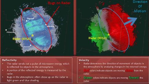
Doppler radar “sees” rainfall, snow, hail, and rotation sort of how a bat uses echolocation to “see” its prey. The radar can see more than that though. Just like a bat needs to see a wall as much as it needs to see prey, the radar can see anything that crosses its path. Sometimes the atmosphere bends the radar’s beam in a way that allows it to pick up objects that it couldn’t normally do. This is called “refraction” or “ducting.”
Below are 15+ examples of when a Doppler radar has picked up more than just rain:
1. Catching a Lift
On Monday, the radar in Billings, Mont., caught a glimpse of an interesting feature on an otherwise inactive day. This odd feature was investigated by the local National Weather Service office after an inquiry was received via Twitter. It was eventually determined that the radar was in fact picking up a chairlift at the Red Lodge Mountain ski area.

Trending News
The darkest pixels match up almost perfectly with the ski area. Even the lighter blips line up with the various ski runs.

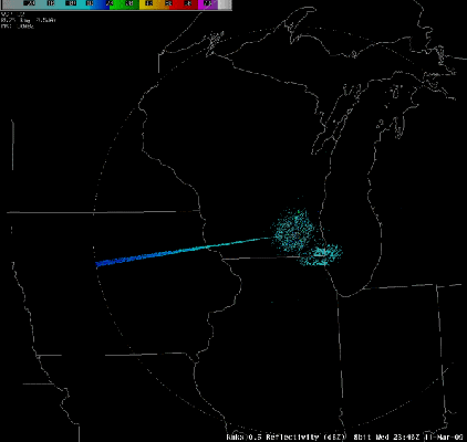
2. Solar Power
Another more common occurrence is the Doppler radar sweeping across a sunrise or a sunset. The Doppler radar’s beam is a pulse of electromagnetic energy. Naturally, as it awaits for its pulses to return by bouncing off of a thunderstorm, it sometimes points directly at the sun during dawn or dusk. The interference caused by the sun’s energy causes the radar to read a “spike” of energy. This photo was taken March 11, 2009 in Madison, Wis., just before the spring equinox. Less than two weeks later, the sun set due west of the radar. It’s a cool little observation to confirm that the earth is in fact tilting back and forth.
3. ?????
I caught this one recently myself. I was curious as to what was happening. It was similar to a sunset/sunrise, but it happened to be in a faint 360° pattern, as opposed to one strong beam of feedback. One thought was that it could be hitting oil rigs or buildings, but the error shows up in an almost symmetrical pattern. I think it could possibly be the radar picking up the suns reflection from buildings or other structures as opposed to the sun itself. What do you think?

4. Birdseye View
The following radar image shows Hurricane Hermine before it makes landfall. The left is a typical radar image you’re used to seeing on TV. The image on the right is one of the “modes” used to identify non-precipitation (anything other than liquid/solid water) objects. It’s called differential reflectivity. The fact that the eye of the storm has a distinct red color shows that the objects being picked up are not “spherical” shape like rain or hail. What you’re looking at is a group up birds trapped inside the calm eye of Hurricane Hermine.

5. Take a Gander at This
Apparently geese also like to stargaze. According to the National Weather Service in Memphis, this flock of geese appeared to be “chasing” the International Space Station. The grayish color shows the geese flying over northeastern Arkansas. The geese briefly flew below the radar, but were later picked up again in Mississippi.
Large flock of geese chasing the ISS. #arwx #tnwx #mswx pic.twitter.com/a3JwaxWWCG
— NWS Memphis (@NWSMemphis) February 16, 2017
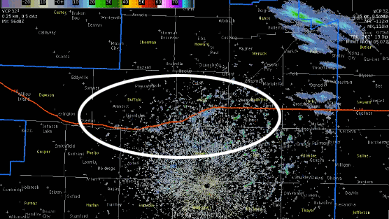
6. Cranehusker State
Birds on radar are pretty commonplace as far as weird radar images go. This image from March 2, 2016 shows birds hanging around the Platte River in Nebraska, near Interstate 80 (the red line). This was confirmed by video later that showed a large number of sandhill cranes in the area.
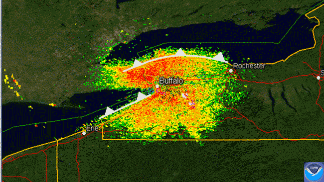
7. Buffalo Chickens
This image from the evening of April 12, 2012 shows a group of birds migrating just after sunset. The cold front (or in this case, bird front) outlines were penciled in my Tom Niziol of The Weather Channel to illustrate the leading edge of the bird migration as it heads from the south shores of both Lakes Erie and Ontario across the water.
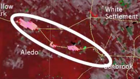
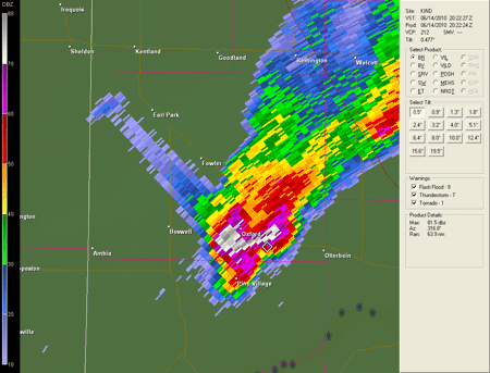
8. Highly Wreck-Amended
As the Doppler radar can identify rotation to see what particles are moving toward (green) or away (red) from the radar, this image from the Dallas-Fort National Weather Service Office shows traffic moving away from the radar. This happened along Interstate 20 on June 26, 2016. They are pink because their speed is much greater than what is floating in the air; about 60mph.
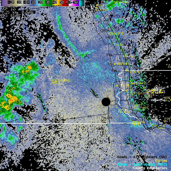
9. How’s This for a One-Liner
You’ll need to look closely for this one. The black circle is known as the “cone of silence.” This is where the radar is actually located. In this case, this is the National Weather Service in El Paso, Texas. The area immediately surrounding the radar is always black, but look to the top right and you’ll see a brief red streak moving northwest. This is actually a train leaving the terminal.
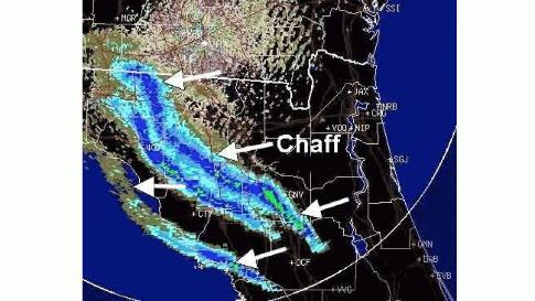
10. Chafing My View
Another common sight on the radar like this one outside Jacksonville Fla., is when the military drops what’s known as “chaff” in the atmosphere. Chaff are small pieces of aluminum released by military aircraft to avoid radar detection. Seems to be working.
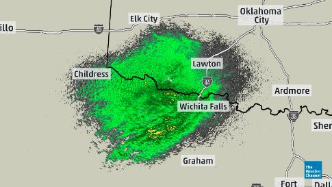
11. Here’s a Burning Question
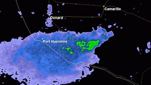
Smoke is often seen on radar. The recent fires in eastern Tennessee were clearly visible on radar. California, who is no stranger to wildfires, can also send smoke plumes into the atmosphere and it is picked up on radar. This example is from May 2, 2013 near Camarillo, Calif.
12. Big Fans of Renewable Energy
A wind farm west of Milwaukee, Wis., showed up on radar recently. These wind turbines are tall enough to occasionally obstruct the radar. The National Weather Service in Jefferson County, Wis., confirmed that “a small part of the electromagnetic energy radar beam sent from the radar [was] reflected back by the rotating turbines.”

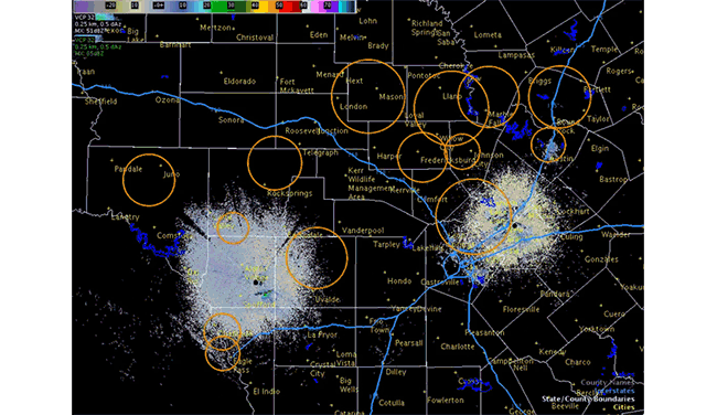
13. A Real-Life Bat Signal
This image comes from the National Weather Service office in San Antonio, Texas from June 13, 2016. You can see growing circles on the radar imagery. These circles are actually emerging bat colonies as they wake up and depart for the evening to feast. In central Texas, this is a common occurrence in the summertime.
14. Hail Spikes
This feature actually has to to with meteorology. Hail stones can be so large and so "reflective," that the radar beam will literally bounce off a storms hail core and run straight into the ground. What you see on radar is a "spike" feature, behind a thunderstorm, when in reality, you're seeing the radar scan directly below the storm.
15. Here Are Several More Images to "Insect"
Bugs are also a common feature on the radar. Here are several examples from across the country:
A local feature, here are insects being picked up by our local radar in southeast Louisiana.
We're used to seeing bird flocks on radar at sunrise, but it looks like insect swarms are getting picked up tonight. pic.twitter.com/ohord8G8lJ
— NWS New Orleans (@NWSNewOrleans) May 30, 2016
Mayfly hatching along the Mississippi River near LaCrosse, Wis.

Grasshoppers and beetles detected by the Texas and Oklahoma border. (H/T The Weather Channel)
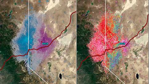
Monarch butterfly migration outside Reno, Nev. The image to the right (differential reflectivity) shows that the objects are not spherical in nature.
Bugs outside Flagstaff, Ariz.
More News
