

Latest Weather Blog
Quiet locally, a tropical note
A glimpse at the 7-Day forecast will have you thinking, “May.”
THE FORECAST:
Today and Tonight: Keeping in a similar pattern, Tuesday will again bring mostly sunny skies with a high temperature in the upper 80s. A touch more humidity may be noticed—but overall, not too bad. Winds will be light and southeasterly. The overnight hours will be mostly clear with a low in the upper 60s.
Up Next: A slightly better chance at pop-up showers is expected on Wednesday as some moisture returns to the area, meaning you will feel some humidity as well. Highs will again peak in the upper 80s. Overnight lows will be around 70 degrees. The same forecast will go up on the board through Friday. Measurable rain should not be found in more than 20% of the 13 Parish, 3 County forecast area through the week. By Saturday, we’ll bring in a little better opportunity at scattered storms but even this looks unimpressive right now.
THE SCIENCE:
Forecast Discussion: After today, an upper-level ridge will back off somewhat and allow ripples of energy in the jet stream to have a better chance at sparking showers and thunderstorms—primarily during peak heating hours. Model precipitation output is almost nil through Tuesday, with only the ECMWF suggesting some minor accumulated rain on Wednesday and Thursday. Therefore, if any showers do develop, they will be insignificant. Vorticity and uplift look a little more favorable Thursday and Friday and thus slightly higher rain chances may be reflected. A shortwave trough axis will cut across the Mid-Mississippi River Valley on Saturday and this should come with a little better shot at scattered showers and thunderstorms, but again, the daytime heat will be needed to get action started. The Sunday/Monday timeframe is not very clear at this point, but no major disturbances are foreseen, therefore a washout either day is unlikely. Temperatures will be very close to normal through the period.
Trending News
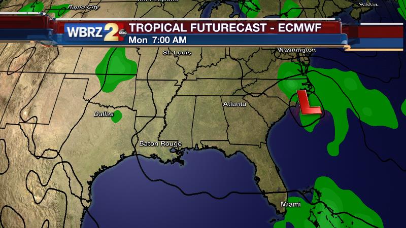
The Tropics: While the local area will be under the influence of a shifting ridge, a deep trough in the Eastern United States could spur some tropical development off of the Southeastern U.S. Coast. Forecast models suggest that the presence of an upper level low may translate into a surface low which could then take on some tropical characteristics. What does this mean for the local area? Next to nothing. What does this mean for the Eastern U.S.? Perhaps some wet weather and increased surf over the Memorial Day Weekend. What does this mean for the tropical season? Very little. As we have noted previously, pre-season storms have not served as a pre-cursor to a more active season. Over a 50 year period to 2015, 13 hurricane seasons brought a total of 16 early-season depressions, storms and hurricanes. Looking at the simple numbers alone, there are no trends. April or May storms are not necessarily a pre-cursor to an active season. Actually, 6 of the 13 years finished with fewer named storms than the averages-12 named storms, 6 hurricanes and 2 major hurricanes.
--Josh
For updates, stay connected with Meteorologist Josh Eachus:
More News
