

Latest Weather Blog
Louisiana summers: records fall as averages rise
Only halfway into meteorological summer, a discomforting warm temperature record has already fallen at New Orleans International Airport. 2016 has already brought 13 days where the daily minimum temperature has failed to drop below 80 degrees.
New Orleans Int'l Airport has recorded 13 days w/a low temperature at or above 80 degrees this summer. https://t.co/oliebjbJFE #lawx #nolawx
— NWS New Orleans (@NWSNewOrleans) July 20, 2016
The previous records, which date back to May 1946, came in 2010 and 2011—both had 12 days that remained above 80 degrees. In addition to meteorological summer, the 13 days in 2016 also ties the calendar year record, also previously set in 2010.
By extending records back to January 1893 via the station at Audubon Park, more lamenting lows can be found. So far in 2016, Audubon Park has registered 8 days with a low temperature above 80 degrees. There, the previous record is an astonishing 45 days with a low above 80 degrees—that came in 1980.
Trending News
In Baton Rouge, only one morning has failed to leave the 80s. That occurred on July 5 and kicked off a stretch of four straight mornings with record high minimum temperatures.
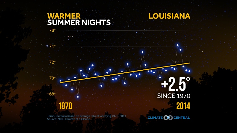
Forty year averages show nighttime temperatures are warming in Louisiana and across the United States. Temperature records at Metro Airport in Baton Rouge date back to 1930. From 1930 to 1969 the average summer low temperature was 71.73 degrees. Then from 1970 to 2015 that number climbed a bit to 72.44 degrees. The statewide plot is a little higher.
When nighttime temperatures stay warm, they can cause health problems by not allowing bodies to cool down after hot days. This can be particularly dangerous for vulnerable populations like the elderly and those without air conditioning. In addition, the 2014 National Climate Assessment said that rising nighttime lows can also strain power grids, as air conditioning demand stays high, and can even negatively impact crops and farm animals.
One meteorological factor that contributes to warming nights is increasing humidity, better measured by dew points. The dew point not only marks the temperature at which air becomes saturated but can also set the basement for low temperatures because air temperatures cannot drop below the dew point. Summed up, humid air just doesn’t cool as efficiently as dry air and thus more nights are staying sultry.

Dew points also have an effect (in some cases opposite) on high temperatures. Just as humid air cools less efficiently at night, it also warms more slowly during the day. That would then suggest that as dew points rise, the average high temperature should come down. However, that is not the case. The same forty year dataset used to identify upward low temperature trends also indicates an upward climb in average high temperatures. For Baton Rouge, the average summer high from 1930 to 1969 was 91.08 degrees and from 1970 to 2015 it was 91.20 degrees—not as remarkable.

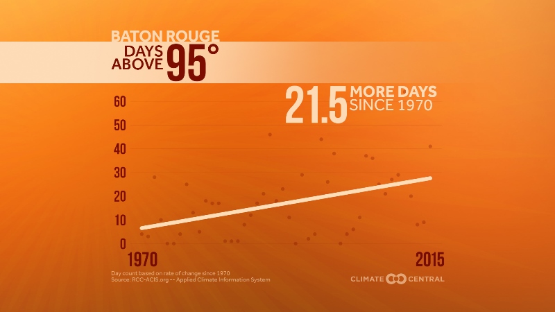
The impact of rising humidity may be somewhat offset by more extremes. In Baton Rouge, very hot days are on the increase, with more and more days reaching maximum temperatures above 95 degrees between 1970 and 2015. Extreme heat is the most common trend found by scientists performing attribution studies on the evolving global climate.
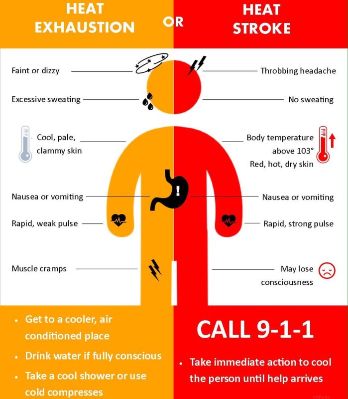
As both temperatures and dew points rise, the number of days in which they combine to raise the risk for heat-related illness may also climb. The number of danger days — days when the heat index (the combination of heat and humidity) is at least 105°F — will likely increase substantially across much of the country. During hot summer days, additional moisture in the air stresses the body by making it harder to cool itself through perspiration. This effect is not just irritating and uncomfortable, but it can also raise the risk of heatstroke and heat exhaustion and in some cases, death. According to the Centers for Disease Control, more than 7,800 people died from heat-related illnesses from 1999-2009. Heat illnesses become even greater concerns in larger cities.
New Orleans, Baton Rouge and the state of Louisiana as a whole are no exception to a rule, and recent overnight warmth is just a small sample of these multi-decadal trends. Cities are further made hotter by the urban heat island effect. Concrete, bricks, and pavement absorb heat during the day and release it at night, which is why cities are warmer than rural locations. However, both rural and urban areas have shown warming in past decades, so urban heat islands are not solely responsible for the observed rise in temperatures.
Via warmer temperatures, feedbacks then begin which creates more evaporation at the surface which injects more moisture into the atmosphere and thus continues to bolster temperatures. The ongoing loop has become evident over the past few years.
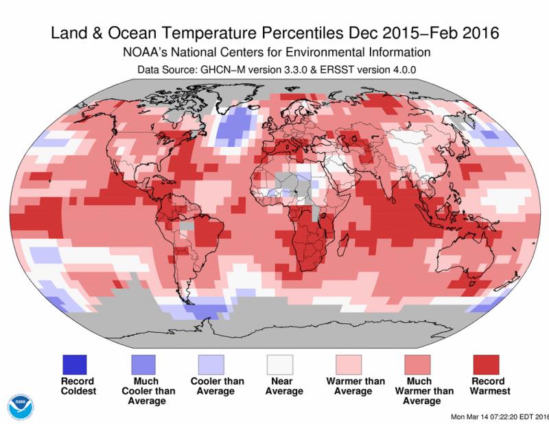
In July, NASA and NOAA released their global temperature analyses for June. Though there are some minor differences in how each calculates average monthly temperatures for earth, both conclude that January to June 2016 was hottest first half of a calendar year on record globally. NOAA added that June 2016 was the 14th consecutive month of record heat for the globe. The year-to-date temperature across global land and ocean surfaces was 1.89°F above the 20th century average of 56.3°F. This was the highest for January-June in the 1880–2016 record.
Contrary to common belief, heat is actually the leading weather related killer. Thus, scientists are continuing to research the cause of increasing temperatures around the globe. In the latest studies climate experts said that higher temperatures can be attributed to increasing greenhouse gas emissions trapping more and more heat in earth’s atmosphere.
Links to additional data and information:
UNITED STATES OFFICIAL CLIMATE INFORMATION WEBSITE
AMERICAN METEOROLOGICAL SOCIETY INFORMATION STATEMENT ON CLIMATE CHANGE
More News
