

Latest Weather Blog
Humidity, rain chances, Mississippi River all on the way up
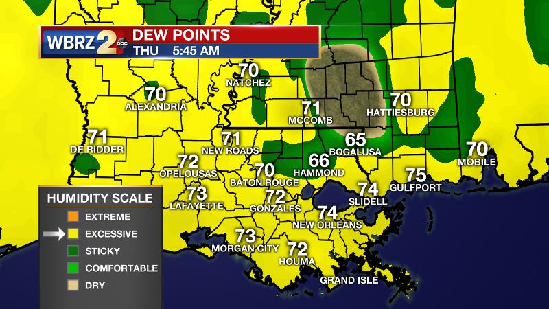
As expected, humidity continues to climb. Overnight, dew points climbed into the low 70s across the forecast area resulting in summerlike morning temperatures in the low 70s. This means the 13 Parish, 3 County forecast area is feeling “sticky” and that will continue through the weekend.
THE FORECAST:
Today and Tonight: Once again, Thursday high temperatures will make it into the upper 80s. Do expect a more humid feel than Monday and Tuesday. Skies will feature a mix of sun and clouds—a few of which may wring out a shower during the afternoon. 13 Parish, 3 County forecast area rain coverage should not exceed 20 percent. Winds will remain southeast at 10mph. Overnight low temperatures will stay mild and muggy in the low 70s.
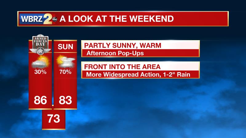
Up Next: Friday and Saturday will be warm and humid with highs topping out in the mid to upper 80s. Pop-up showers and thunderstorms will develop during the afternoon hours, but not all locations will pick up rain. By Sunday, a cold front will move into the region bringing greater coverage in showers and thunderstorms. It is still early, but at this point, it would be a good idea to think about a contingency plan for outdoor events. Some forecast models are beginning to squeeze out a decent amount of precipitation too, which is common from spring or summer showers and storms. By early next week, the region may accumulate 2-3 inches of rain.
Trending News
Runoff from rain in the local area will not make it into the rising Mississippi River. The highest crest in several years is expected for “big muddy” in Baton Rouge. Here is what to expect.
THE SCIENCE: With an upper ridge over the Eastern U.S. and a trough over the Lower Midwest, upper level winds are faster, southwesterly and divergent. In addition to this, cooler temperatures aloft should allow isolated showers and thunderstorms to develop this afternoon, Friday and Saturday. A pocket of positive vorticity advection is depicted in the upper levels, but low to mid-level moisture is only modest. Therefore, rain coverage should not exceed 20 percent either day. A continued southerly surface wind will promote humidity through the weekend. This will be most noticeable in low temperatures which will be in the low 70s. Some fog could potentially form as well. On Sunday, the axis of an upper trough will move across the Upper Mississippi River Valley and may drag a weak cold front through the area. The mechanisms of these features will mean increased rain coverage for the second half of the weekend. The cold front will push east on Monday, however forecast models are holding some showers in the forecast. We will have some time to work out the fine details on this discrepancy.
--Josh
More News
