

Latest Weather Blog
FLASH FLOOD WATCH: Heavy rain threat continues
After some locations already received up to 3” of rain on Wednesday, an additional 4-7” of rain is expected to fall by the end of the weekend. Monitor the weather closely in the event that any flooding issues develop.
Today and Tomorrow: Widespread showers and thunderstorms will bring heavy rain to the area on Thursday and Friday. Action will come in waves. Any thunderstorms will be capable of producing downpours and possibly inches of rain. Secondarily, frequent lightning may be an issue as well. These threats will not only exist during the daytime, peak heat hours but overnight as well. Due to clouds and periods of rain, highs will be limited to the mid 80s with lows in the mid 70s.
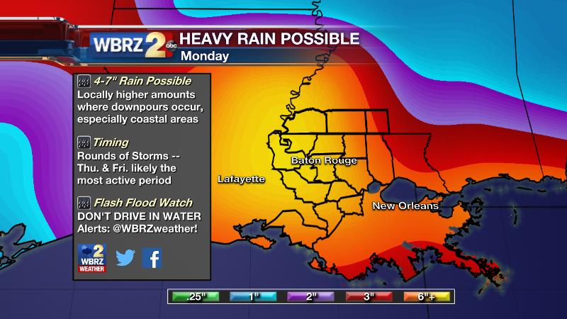
Threats: Much of the area will receive another 4-7” of rain with locally higher amounts as thunderstorm downpours creating localized street flooding. For this reason, a FLASH FLOOD WATCH has been issued into Saturday Morning for the entire forecast area. Depending on where the heaviest rain occurs, river flooding may become a concern as well.
Timing: Rounds of showers and thunderstorms are expected not just during the day but at night as well. Any storms now through Friday Night bring the most widespread flooding threat. However, scattered showers and thunderstorms over the weekend will contribute to the forecast rain totals as well.
Trending News
From the National Weather Service: The areas of greater concern at this time appear to be the Mississippi Gulf Coast counties...the New Orleans Metro area and the rivers that drain into Lake Pontchartrain. To a lesser extent...the heavy rain threat may spread farther west later in the week to include the Amite/Comite Basin and the streams in East-Central Louisiana.
What should I do? The forecast is issued on the basis that conditions are favorable for showers and thunderstorms to create flooding issues. Know that things may change! There a couple of things you can do to be ready.
- Stay in touch with the WBRZ Weather Team for updates and alerts.
- If you live in a flood prone area, prepare now, just in case.
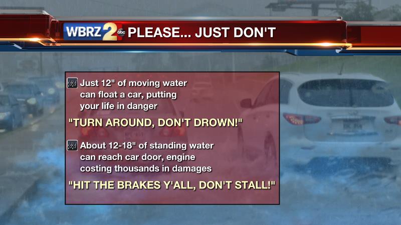
- If you come across rushing water, turn around don’t drown! Several inches of moving water can float a car.
- If you come across a flooded street, hit the brakes y’all, don’t stall! Once the water reaches car doors or engines, damages run into the thousands of dollars. Even if a street you travel every day has standing water, do not attempt to drive across it.
Up Next: Into the weekend, scattered showers and thunderstorms are expected to continue, especially during the afternoon hours, but daily rain coverage and totals will be trending down. High temperatures will be near 90 with lows in the mid 70s. Next week a more standard summer pattern will gradually return with more heat, steam and flare up showers and storms during the afternoons.
THE SCIENCE:
Forecast Discussion: A mid and upper level area of low pressure will move overhead on Thursday and Friday. As has been the expectation all week long, this will mark a very active 48 hours of weather. The upper energy will enhance convection during the daytime hours—especially as embedded impulses of energy dictate. With that noted, the overnight hours will not be calm as is typical in the summer season. Showers and thunderstorms will continue at night, allowing little time for runoff in some areas that receive heavy rain. In addition, the concern for heavy rainfall shifting further northwest and now includes the Baton Rouge area. The GFS model is starting to catch up to the ECMWF in suggesting rain totals more on the order of 4-7”. Precipitable water values continue to reside in record territory meaning thunderstorms will be capable of dropping inches of rain per hour. Low level steering winds are not very strong and thus storms may more readily rain out than move along. This type of scenario often results in areal if not flash flooding. So, the National Weather Service has proceeded with a FLASH FLOOD WATCH for the local area into Saturday Morning. It is worth noting that these more coarsely scaled, global models do not pick up well on microscale banding of thunderstorms that can often create localized flooding and thus a plus on the upper end of the rain forecast is needed. Only hourly radar trends once the event begins will show where the heaviest areas of precipitation will take shape and thus where flash flooding may be a concern. An upper trough moving eastward across the midsection of the country from Saturday through Monday will aide in keeping rain chances on the higher side for the area. However, at this time it appears that day to day rain totals will be on the downward trend.
--Josh
For updates, stay connected with Meteorologist Josh Eachus:
More News
