

Latest Weather Blog
El Nino fizzling: what does this mean for the upcoming hurricane season?
El Niño is scheduled to depart while the likelihood is increasing that La Niña will take over. For climate pundits, it should come as no surprise that the tropical research team with Colorado State University is predicting average activity for the 2016 Atlantic Hurricane Season.
Their outlook calls for an additional* 12 named storms and 5 hurricanes with two being considered major (category 3 strength or higher). Annual averages are 12 named storms, 6 hurricanes and 3 major hurricanes.
*Hurricane Alex already struck the Azores earlier this year--a rare January storm.

The annual Colorado State prediction is based on a statistical model developed with 29 years of data. Seasonal updates are issued on June 1 and August 3.
Trending News
Notable for Gulf Coast interests, the experts calculated a 58-percent chance of a hurricane landfall for areas between Brownsville, Texas and the Florida Panhandle and an 82-percent chance of a named storm landfall. Those numbers fall just shy of the 100 year averages of 60-percent and 83-percent.
Researchers Philip Klotzbach and William Gray cited a weakening El Niño as reason to trend away from predictions of below average action issued over the last few years. The development of a La Niña late in the season will continue to decrease wind shear. However, the team says the North Atlantic Ocean temperatures are unusually cold which is less conducive to development.
As defined by the National Oceanic and Atmospheric Administration (NOAA), El Niño and La Niña are the warm and cool phases of a recurring climate pattern across the tropical Pacific—the El Niño-Southern Oscillation, or “ENSO” for short. We keep in mind that El Niño and La Niña do not “cause” any one specific weather event; rather the two phases of ENSO influence change in global climate patterns that then increase the likelihood of specific weather events.

For instance, recent bouts and heavy rain and severe weather along the Gulf Coast coincide with expectations for an El Niño spring. Historically, El Niño also has strong ties to quieter hurricane seasons as well.
On the other hand, La Niña is a pattern which favors much more activity in the Atlantic Basin during hurricane season. During La Niña, trade winds weaken over the Atlantic Ocean creating a more supportive environment for tropical cyclone formation.
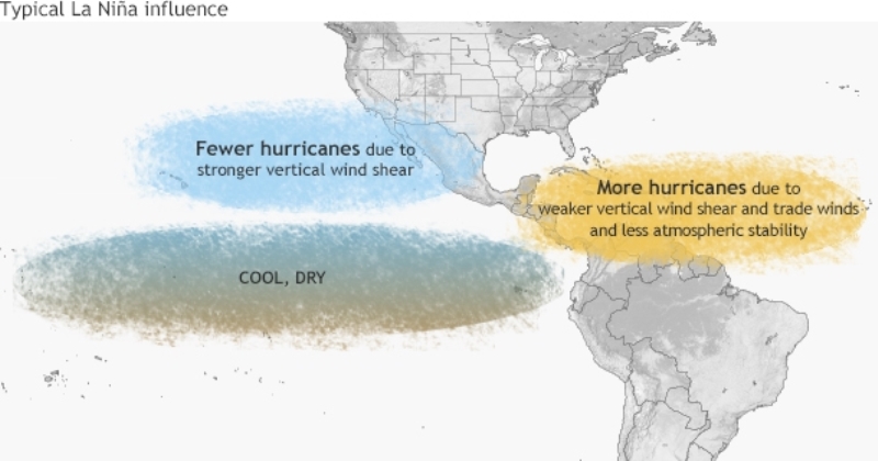
Once again, ENSO is not “to blame” for any one storm system, temperature anomaly or hurricane. If La Niña does indeed develop, the Atlantic Basin faces an increased chance at above average tropical activity. Despite higher chances, it is much too early to determine where storms will develop or where they will go.
For that reason, the WBRZ Weather Team reminds that “it only takes one hurricane making landfall to make it an active season for you,” so prepare accordingly. NOAA’s official outlook is expected in Late May. For more on the season ahead and preparedness, stay tuned to WBRZ for our annual special, “Weathering the Storm.”
More News
