

Latest Weather Blog
Continued chance for wintry mix Friday Evening
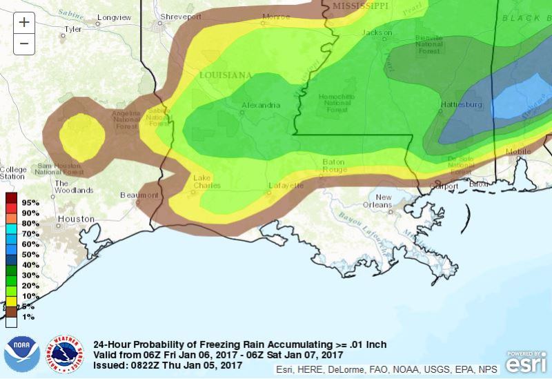
Though still not a certainty, the possibility of frozen precipitation has increased for parts of the WBRZ Weather forecast area. Rain could mix with sleet in and around Baton Rouge, but a full transition to frozen precipitation could briefly occur for locations north of I-12. As clouds and pockets of rain persist on Friday, cold air advancing from the north will guide thermometers down through the afternoon. Expect an early high in the upper 40s with readings in the mid 30s by evening. Rain will begin to mix with frozen precipitation from northwest to southeast during the afternoon. While no snow accumulation is possible in the local area, some locations have a 20-30% of picking up a light glaze of ice.
Precipitation Forecast (medium confidence):
Rain only: Ascension, Assumption, St. James, St. Mary Parishes
Rain and sleet: East Baton Rouge, Iberville, Livingston, West Baton Rouge Parishes
Trending News
Rain, sleet and possibly freezing rain: East Feliciana, St. Helena, Tangipahoa Parishes
Rain, sleet, freezing rain and possibly snow: Pointe Coupee, West Feliciana Parishes and Amite, Pike, Wilkinson Counties
Current Timeline (low confidence):
Pointe Coupee, West Feliciana Parishes and Amite, Pike, Wilkinson Counties:
3pm – rain mixing with sleet
5pm – full transition to sleet, freezing rain
7pm – snow may mix in
11pm – precipitation ends
East Feliciana, St. Helena, Tangipahoa Parishes:
4pm – rain mixing with sleet
6pm – full transition to sleet, freezing rain
12am – precipitation ends
East Baton Rouge, Iberville, Livingston, West Baton Rouge Parishes:
5pm – rain mixing with sleet
12am – precipitation ends
Ascension, Assumption, St. James, St. Mary Parishes:
12am – rain ends
Impacts (medium confidence): In the event of an extended period of freezing rain near and north of the Louisiana/Mississippi border, a light glaze of ice, up to an eighth of an inch, could coat trees and power lines. However, this would not be thick enough to down branches or knock out power. In addition, any coating of freezing rain could make driving hazardous. With temperatures dropping below freezing overnight all the way to the I-10 corridor, lingering surface moisture will freeze and some roadways or bridges could develop ice. Any thin slick spots will melt as the sun returns on Saturday Morning.
Actions: If you live along and north of I-12, monitor the forecast. If frozen precipitation does materialize, have “stay at home” plans for Friday Night as driving could become dangerous. The National Weather Service may issue advisories to highlight this risk.
WEATHER DISCUSSION: the two major computer forecast models have sped up the arrival of cold air and the end of precipitation, but present an increased likelihood of frozen precipitation and some minor impacts. An area of low pressure will move northeastward through the Gulf of Mexico will a very cold air mass advances into the region. A front associated with the surface low pressure system will cause overrunning precipitation through Friday. As cold air wedges in at the surface, a transition from rain to sleet and freezing rain is expected to occur Friday Afternoon. Exactly where the cutoff between liquid and frozen precipitation occurs will be very difficult to determine, but here is the latest thinking:
In examining a vertical profile of the atmosphere, a warm layer in the lower levels exceeding 3 degrees Celsius will initially exist. Such a warm layer means complete melting of any ice or snow falling through the atmosphere will occur. Below that, will be another freezing layer possibly deep enough for liquid to refreeze into sleet pellets. The ground temperature will be very close to freezing. The warm layer is expected to cool from northwest to southeast through the event. As this occurs, rain will begin to transition to mix with sleet in the same direction. Once surface temperatures slip to or below 32 degrees, freezing rain will begin to glaze surfaces. If the low-level warm layer erodes entirely, some snow may be observed.
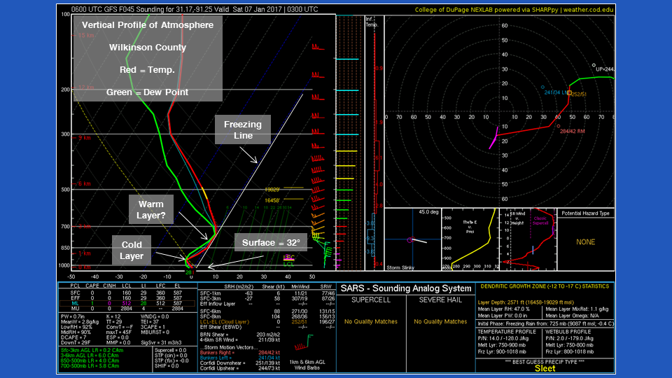
Full erosion of the low-level warm layer is expected to occur for locations north of a line between New Roads and Kentwood and surface temperatures will be below freezing. As such, rain will begin to mix with sleet as early as Friday Afternoon and become a combination of light freezing rain, sleet and possibly snow before ending Friday Night. With temperatures remaining below freezing Friday Night, roads and bridges could become icy.
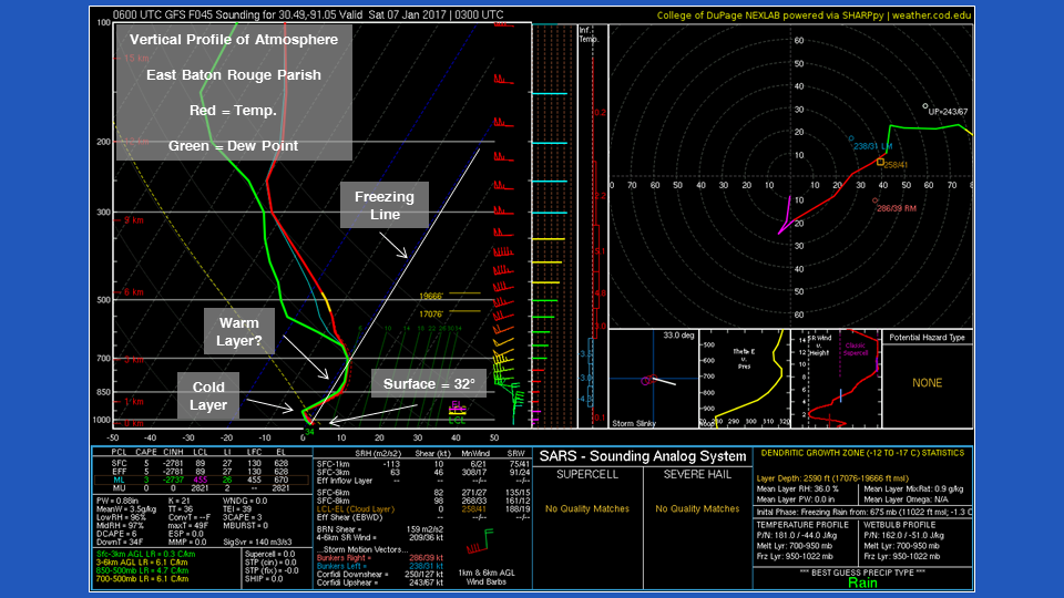
For Baton Rouge and areas along the I-12 corridor, the atmosphere is forecast to have a much tougher low level warm layer. A shallow cold pocket above the surface will allow some refreezing and sleet to mix with rain. A full transition is unlikely before the precipitation ends. However, with the surface temperature dropping below freezing Friday Night, some icy spots may still occur.
For areas south of Baton Rouge, the warm layer will be too thick and surface temperatures will stay above freezing until Saturday Morning. Therefore, only rain is expected and no icy spots are anticipated.
It is worth repeating that, while this forecast is not a lock, the chance of wintry weather has increased. Either way, given the rare instance of frozen precipitation in the Baton Rouge area, the possibility is worth discussing. Stick with the WBRZ Weather Team on Facebook and Twitter and catch forecast on WBRZ News 2 for updates through the week.
Related Stories
More News
